Trail Walking Chirols - Ste Marguerite - Photo
 Michel07
Michel07

User

© OpenStreetMap contributors
Length
Length
12.7 km
Max alt
Max alt
982 m
Uphill gradient
Uphill gradient
712 m
Km-Effort
Km-Effort  
22 km
Min alt
Min alt
348 m
Downhill gradient
Downhill gradient
710 m
Boucle
Boucle
Yes
Creation date :
2014-12-10 00:00:00.0
Updated on :
2014-12-10 00:00:00.0

(2 Reviews)

Walking
Walking
3h57
Difficulty : Medium

Scan this QR Code to open this trail in the SityTrail application

FREE GPS app for hiking

Logo SityTrail SityTrail

IGN / Geographical institutes

Download SityTrail from the App Store Download SityTrail from Google Play

Logo SityTrail SityTrail World

The world is yours!

Download SityTrail from the App Store Download SityTrail from Google Play Download SityTrail on Huawei AppGallery

About

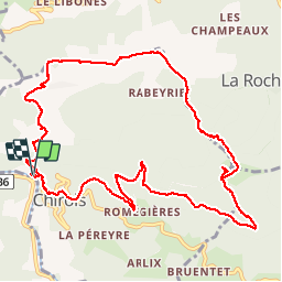
Trail Walking of 12.7 km to be discovered at Auvergne-Rhône-Alpes, Ardèche, Chirols. This trail is proposed by Michel07.

Elevation profile

Positioning

Country:
France
Region :
Auvergne-Rhône-Alpes
Department/Province :
Ardèche
Municipality :
Chirols
Location:
Unknown
Start:(UTM)
601708 ; 4949084 (31T) N.

Comments

Please log in to post a review or rate the element


Très belle marche,beaucoup de belles vues et des hameaux splendides


très joli circuit varié. une belle crête


Trails nearby

Trail Walking Saint-Pierre-de-Colombier - SityTrail - 2775482 - st-pierre-burzet - Photo
Walking
coureursdecretes

Walking

Very difficult
(1)
Saint-Pierre-de-Colombier, Auvergne-Rhône-Alpes, Ardèche, France
11.5 km | 17.1 km-effort
4h 45min
Yes
Trail Walking Labastide-sur-Bésorgues - 2022-02-01_15h56m32_Les granges de Sausses 14,5km.GPX.xml - Photo
Walking
chancha

Walking

Difficult
(1)
Labastide-sur-Bésorgues, Auvergne-Rhône-Alpes, Ardèche, France
14.1 km | 24 km-effort
5h 37min
Yes
Trail Walking Aizac - SityTrail - 2231069 - aizacxmal-combexla-bastide-sur-besorgue- - Photo
Walking
coureursdecretes

Walking

Difficult
(1)
Aizac, Auvergne-Rhône-Alpes, Ardèche, France
10.3 km | 17.4 km-effort
3h 57min
Yes
Trail Walking Fabras - Fabras  - Photo
Walking
MoiClaude

Walking

Medium
(1)
Fabras, Auvergne-Rhône-Alpes, Ardèche, France
6.4 km | 9.7 km-effort
1h 49min
No
Trail Walking Aizac - Aizac et la coupe d'Aizac - Photo
Walking
mikaou.t

Walking

Easy
(1)
Aizac, Auvergne-Rhône-Alpes, Ardèche, France
4.5 km | 7.5 km-effort
1h 24min
Yes
Trail Walking Meyras - neyrac les bains - Photo
Walking
raab

Walking

Easy
(1)
Meyras, Auvergne-Rhône-Alpes, Ardèche, France
4.4 km | 6.8 km-effort
1h 36min
Yes
Trail Walking Thueyts - 231217 Thueyts-Brige - Photo
Walking
Rudy07

Walking

Easy
(1)
Thueyts, Auvergne-Rhône-Alpes, Ardèche, France
5.7 km | 9.6 km-effort
2h 11min
Yes
Trail Walking Fabras - Fabras Jaujac les orgues basaltiques  - Photo
Walking
GUIDE
Roger Philippe Wallez

Walking

Very difficult
Fabras, Auvergne-Rhône-Alpes, Ardèche, France
14.9 km | 22 km-effort
5h 17min
Yes
Trail Walking Meyras - Balade Neyrac Bas - Neyrac haut - Souihol - Photo
Walking
coureursdecretes

Walking

Medium
(1)
Meyras, Auvergne-Rhône-Alpes, Ardèche, France
5.9 km | 9 km-effort
2h 2min
Yes


Close
My subscriptions