Trail Walking Soleilhas -  La Sagne - Photo
 cswilly
cswilly

User

© OpenStreetMap contributors
Length
Length
16.5 km
Max alt
Max alt
1358 m
Uphill gradient
Uphill gradient
725 m
Km-Effort
Km-Effort  
26 km
Min alt
Min alt
1062 m
Downhill gradient
Downhill gradient
725 m
Boucle
Boucle
Yes
Creation date :
2014-12-10 00:00:00.0
Updated on :
2014-12-10 00:00:00.0

(1 Reviews)

Walking
Walking
6h22
Difficulty : Medium

Scan this QR Code to open this trail in the SityTrail application

FREE GPS app for hiking

Logo SityTrail SityTrail

IGN / Geographical institutes

Download SityTrail from the App Store Download SityTrail from Google Play

Logo SityTrail SityTrail World

The world is yours!

Download SityTrail from the App Store Download SityTrail from Google Play Download SityTrail on Huawei AppGallery

About

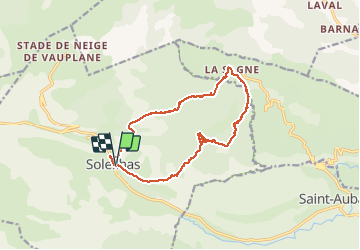
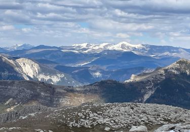
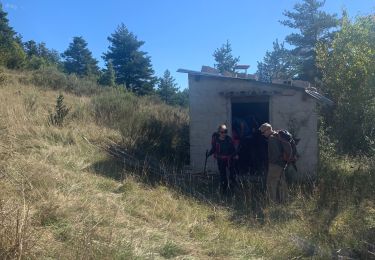
Trail Walking of 16.5 km to be discovered at Provence-Alpes-Côte d'Azur, Alpes-de-Haute-Provence, Soleilhas. This trail is proposed by cswilly.

Description

Nous avons cherché le chemin 300m après St Pierre. Juste avant la cascade le chemin monte les rochers (marqués en jaune et orange) pour surplomber la cascade. Il faudrait donc enlever 30 minutes, 0,8km et 80m.
         

Elevation profile

Positioning

Country:
France
Region :
Provence-Alpes-Côte d'Azur
Department/Province :
Alpes-de-Haute-Provence
Municipality :
Soleilhas
Location:
Unknown
Start:(UTM)
311216 ; 4858696 (32T) N.

Comments

Please log in to post a review or rate the element


Superbe


Trails nearby

Trail Walking Soleilhas - Le Crémon depuis le Col St Barnabé  - Photo
Walking
Marchopier

Walking

Medium
(1)
Soleilhas, Provence-Alpes-Côte d'Azur, Alpes-de-Haute-Provence, France
17 km | 28 km-effort
8h 18min
No
Trail Walking Soleilhas - Crête de Bernarde - Photo
Walking
domi06

Walking

Medium
Soleilhas, Provence-Alpes-Côte d'Azur, Alpes-de-Haute-Provence, France
15.7 km | 25 km-effort
6h 19min
Yes
Trail On foot Peyroules - Sommet du Teillon par Peyroules - Photo
On foot
verotrail

On foot

Difficult
Peyroules, Provence-Alpes-Côte d'Azur, Alpes-de-Haute-Provence, France
13 km | 25 km-effort
Unknown
Yes
Trail Mountain bike Soleilhas - Grande Traversée des PréAlpes à VTT : Stade de Neige de Vauplane - St Auban - Photo
Mountain bike
tracegps

Mountain bike

Difficult
Soleilhas, Provence-Alpes-Côte d'Azur, Alpes-de-Haute-Provence, France
16.4 km | 24 km-effort
2h 30min
No
Trail Walking Peyroules - Teillon face nord - Photo
Walking
jouans

Walking

Very difficult
Peyroules, Provence-Alpes-Côte d'Azur, Alpes-de-Haute-Provence, France
19.5 km | 34 km-effort
5h 19min
Yes
Trail Walking Soleilhas - La Sagne - Photo
Walking
jhw

Walking

Medium
Soleilhas, Provence-Alpes-Côte d'Azur, Alpes-de-Haute-Provence, France
17.5 km | 27 km-effort
5h 27min
No
Trail On foot Briançonnet - La Sagne - Collettes - Photo
On foot
PRO

On foot

Easy
Briançonnet, Provence-Alpes-Côte d'Azur, Maritime Alps, France
4.9 km | 8.5 km-effort
1h 56min
No
Trail Walking Soleilhas - Soleihlas la rascasse - Photo
Walking
SaintEloi4

Walking

Very difficult
Soleilhas, Provence-Alpes-Côte d'Azur, Alpes-de-Haute-Provence, France
13.9 km | 22 km-effort
4h 38min
Yes
Trail Walking Soleilhas - vauplane cretes - Photo
Walking
vincente204

Walking

Very easy
Soleilhas, Provence-Alpes-Côte d'Azur, Alpes-de-Haute-Provence, France
10 km | 16.6 km-effort
3h 20min
Yes


Close
My subscriptions