Trail Mountain bike Canohès - canohes - Photo
© OpenStreetMap contributors
Length
Length
37 km
Max alt
Max alt
345 m
Uphill gradient
Uphill gradient
508 m
Km-Effort
Km-Effort  
44 km
Min alt
Min alt
66 m
Downhill gradient
Downhill gradient
510 m
Boucle
Boucle
Yes
Creation date :
2014-12-10 00:00:00.0
Updated on :
2014-12-10 00:00:00.0

(2 Reviews)

Mountain bike
Mountain bike
2h12
Difficulty : Medium

Scan this QR Code to open this trail in the SityTrail application

FREE GPS app for hiking

Logo SityTrail SityTrail

IGN / Geographical institutes

Download SityTrail from the App Store Download SityTrail from Google Play

Logo SityTrail SityTrail World

The world is yours!

Download SityTrail from the App Store Download SityTrail from Google Play Download SityTrail on Huawei AppGallery

About

Trail Mountain bike of 37 km to be discovered at Occitania, Pyrénées-Orientales, Canohès. This trail is proposed by haroldtheviking.

Elevation profile

Positioning

Country:
France
Region :
Occitania
Department/Province :
Pyrénées-Orientales
Municipality :
Canohès
Location:
Unknown
Start:(UTM)
486253 ; 4721730 (31T) N.

Comments

Please log in to post a review or rate the element


tres pratique mais j'aimerais modifier ce que j'ai mis moi-même je ne sais pas comment faire


une fois pris en main, c'est vraiment pratique


Trails nearby

Trail Walking Perpignan - canal Perpignan  - Photo
Walking
Fildesir

Walking

Very easy
Perpignan, Occitania, Pyrénées-Orientales, France
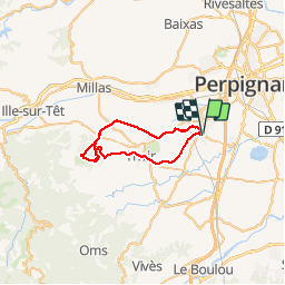
25 km | 27 km-effort
7h 29min
No
Trail Walking Perpignan - 66 Perpignan Panchot centre bas Vernet centre del mon - Photo
Walking
jeff66

Walking

Easy
Perpignan, Occitania, Pyrénées-Orientales, France
8.6 km | 9.3 km-effort
1h 29min
Yes
Trail Walking Perpignan - 66 PERPIGNAN - autour des mas Du petit et du grand Bresson - Photo
Walking
jeff66

Walking

Easy
Perpignan, Occitania, Pyrénées-Orientales, France
4.3 km | 4.9 km-effort
52min
Yes
Trail Walking Perpignan - 66 PERPIGNAN, du sud au Nord Et retour - Photo
Walking
jeff66

Walking

Medium
Perpignan, Occitania, Pyrénées-Orientales, France
13.8 km | 15.4 km-effort
2h 40min
Yes
Trail Walking Perpignan - 66 PERPIGNAN - CANOHES par le canal et le ch. des Carlettes - Photo
Walking
jeff66

Walking

Medium
(1)
Perpignan, Occitania, Pyrénées-Orientales, France
9.4 km | 10.1 km-effort
1h 45min
Yes
Trail Walking Perpignan - 66 PERPIGNAN porte Espagne, les arcades, saint Martin, moulin à vent, vertefeuille, mas Gaffard - Photo
Walking
jeff66

Walking

Medium
Perpignan, Occitania, Pyrénées-Orientales, France
10.3 km | 11.7 km-effort
1h 48min
Yes
Trail Walking Perpignan - 66 PERPIGNAN, porte d'Espagne, quartier des aviateurs, les Arcades, Serrat d'en Vaquer, els Canals - Photo
Walking
jeff66

Walking

Easy
Perpignan, Occitania, Pyrénées-Orientales, France
10.1 km | 11.5 km-effort
1h 52min
Yes
Trail Walking Perpignan - 66 PERPIGNAN, canal de Perpignan, centre commercial porte d'espagne, aqueduc des arcades, Ch. de Mailloles et de STE Barbe, Serrat d'en Vaquer - Photo
Walking
jeff66

Walking

Easy
Perpignan, Occitania, Pyrénées-Orientales, France
9.8 km | 11.5 km-effort
1h 45min
Yes
Trail Walking Perpignan - 66 PERPIGNAN - de la Z.I.Sud au Centre Ville et retour par Saint-Mathieu - Photo
Walking
jeff66

Walking

Easy
Perpignan, Occitania, Pyrénées-Orientales, France
7.8 km | 8.5 km-effort
1h 28min
Yes


Close
My subscriptions