Trail Walking Marchenoir - 04-Marchenoir - Villermain - Photo

04-Marchenoir - Villermain

 SERUS
SERUS

User

© OpenStreetMap contributors
Length
Length
20 km
Max alt
Max alt
158 m
Uphill gradient
Uphill gradient
97 m
Km-Effort
Km-Effort  
22 km
Min alt
Min alt
116 m
Downhill gradient
Downhill gradient
107 m
Boucle
Boucle
No
Creation date :
2019-05-19 20:39:14.776
Updated on :
2019-05-19 20:39:14.849

(0 Reviews)

Walking
Walking
--
Difficulty : Easy

Scan this QR Code to open this trail in the SityTrail application

FREE GPS app for hiking

Logo SityTrail SityTrail

IGN / Geographical institutes

Download SityTrail from the App Store Download SityTrail from Google Play

Logo SityTrail SityTrail World

The world is yours!

Download SityTrail from the App Store Download SityTrail from Google Play Download SityTrail on Huawei AppGallery

About

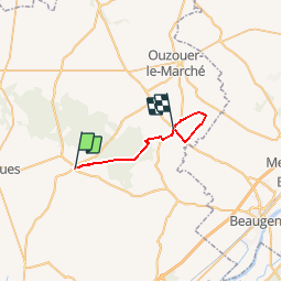
Trail Walking of 20 km to be discovered at Centre-Loire Valley, Loir-et-Cher, Marchenoir. This trail is proposed by SERUS.

Description

Chemin de Vendome à Orléans par Oucques

Elevation profile

Positioning

Country:
France
Region :
Centre-Loire Valley
Department/Province :
Loir-et-Cher
Municipality :
Marchenoir
Location:
Unknown
Start:(UTM)
380092 ; 5297842 (31T) N.

Trails nearby

Trail Road bike Muides-sur-Loire - Itinéraire 12 - Au fil de Loire - Photo
Road bike
verpoorten

Road bike

Very difficult
(1)
Muides-sur-Loire, Centre-Loire Valley, Loir-et-Cher, France
39 km | 43 km-effort
2h 36min
Yes
Trail Walking Tavers - Travers 45 - Photo
Walking
Gablier

Walking

Very easy
Tavers, Centre-Loire Valley, Loiret, France
11.3 km | 12.5 km-effort
2h 27min
No
Trail Walking Coulommiers-la-Tour - Coulommiers-la-Tour - Photo
Walking
guydu41

Walking

Medium
Coulommiers-la-Tour, Centre-Loire Valley, Loir-et-Cher, France
9.4 km | 11 km-effort
2h 29min
Yes
Trail Walking Fréteval - Fréteval - Photo
Walking
guydu41

Walking

Medium
Fréteval, Centre-Loire Valley, Loir-et-Cher, France
10.8 km | 12.5 km-effort
2h 50min
Yes
Trail Walking Renay - Renay - Photo
Walking
guydu41

Walking

Easy
Renay, Centre-Loire Valley, Loir-et-Cher, France
13.8 km | 15.8 km-effort
3h 35min
Yes
Trail Hybrid bike Muides-sur-Loire - Muides Blois Chambord  - Photo
Hybrid bike
karani27

Hybrid bike

Medium
Muides-sur-Loire, Centre-Loire Valley, Loir-et-Cher, France
51 km | 57 km-effort
4h 41min
No
Trail Walking Marolles - Site naturel et archéologique de la Grande Pierre et Vitain - Photo
Walking
guydu41

Walking

Medium
Marolles, Centre-Loire Valley, Loir-et-Cher, France
8.1 km | 9 km-effort
2h 2min
Yes
Trail On foot Beaugency - Sentier de la petite Mauve - Photo
On foot
PRO

On foot

Easy
Beaugency, Centre-Loire Valley, Loiret, France
4.5 km | 4.8 km-effort
1h 5min
No
Trail Walking Saint-Hilaire-la-Gravelle - Saint-Hilaire-la-Gravelle - Entre Loir et étangs  - Photo
Walking
guydu41

Walking

Easy
Saint-Hilaire-la-Gravelle, Centre-Loire Valley, Loir-et-Cher, France
16.5 km | 18.9 km-effort
4h 44min
Yes


Close
My subscriptions