Trail Walking Meung-sur-Loire - 04A- Meung - Orléans par le GR3 - Photo

04A- Meung - Orléans par le GR3

 SERUS
SERUS

User

© OpenStreetMap contributors
Length
Length
19.6 km
Max alt
Max alt
117 m
Uphill gradient
Uphill gradient
184 m
Km-Effort
Km-Effort  
22 km
Min alt
Min alt
83 m
Downhill gradient
Downhill gradient
170 m
Boucle
Boucle
No
Creation date :
2019-05-19 20:39:11.193
Updated on :
2019-05-19 20:39:11.255

(0 Reviews)

Walking
Walking
--
Difficulty : Easy

Scan this QR Code to open this trail in the SityTrail application

FREE GPS app for hiking

Logo SityTrail SityTrail

IGN / Geographical institutes

Download SityTrail from the App Store Download SityTrail from Google Play

Logo SityTrail SityTrail World

The world is yours!

Download SityTrail from the App Store Download SityTrail from Google Play Download SityTrail on Huawei AppGallery

About

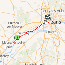
Trail Walking of 19.6 km to be discovered at Centre-Loire Valley, Loiret, Meung-sur-Loire. This trail is proposed by SERUS.

Description

Chemin de Vendome à Orléans par Boisseau et Meung

Elevation profile

Positioning

Country:
France
Region :
Centre-Loire Valley
Department/Province :
Loiret
Municipality :
Meung-sur-Loire
Location:
Unknown
Start:(UTM)
402560 ; 5297645 (31T) N.

Trails nearby

Trail Walking Saint-Ay - ST AY bords de Loire 2 - Photo
Walking

Walking

Difficult
(1)
Saint-Ay, Centre-Loire Valley, Loiret, France
12 km | 13.4 km-effort
2h 57min
Yes
Trail Mountain bike Meung-sur-Loire - Les deux ponts - Meung sur Loire - Beaugency - Photo
Mountain bike
tracegps

Mountain bike

Medium
Meung-sur-Loire, Centre-Loire Valley, Loiret, France
17.1 km | 18.4 km-effort
2h 0min
Yes
Trail Walking Meung-sur-Loire - Les deux ponts - Meung sur Loire - Beaugency - Photo
Walking
tracegps

Walking

Medium
Meung-sur-Loire, Centre-Loire Valley, Loiret, France
17.1 km | 18.4 km-effort
4h 0min
Yes
Trail Cycle Cléry-Saint-André - Cléry Saint André - Photo
Cycle
tracegps

Cycle

Easy
Cléry-Saint-André, Centre-Loire Valley, Loiret, France
19.2 km | 20 km-effort
1h 45min
Yes
Trail Road bike Baule - 3 - Photo
Road bike
eymerick

Road bike

Very difficult
Baule, Centre-Loire Valley, Loiret, France
46 km | 50 km-effort
3h 3min
No
Trail Road bike Meung-sur-Loire - Beautency - Photo
Road bike
Banaszak

Road bike

Meung-sur-Loire, Centre-Loire Valley, Loiret, France
18 km | 19.7 km-effort
1h 12min
Yes
Trail Walking Cléry-Saint-André - cler y3 - Photo
Walking
Rembliere

Walking

Easy
Cléry-Saint-André, Centre-Loire Valley, Loiret, France
4.3 km | 4.7 km-effort
1h 3min
Yes
Trail Walking Cléry-Saint-André - Clery 2 - Photo
Walking
Rembliere

Walking

Easy
Cléry-Saint-André, Centre-Loire Valley, Loiret, France
4.3 km | 4.5 km-effort
1h 1min
Yes
Trail Walking Cléry-Saint-André - Clery 1 - Photo
Walking
Rembliere

Walking

Easy
Cléry-Saint-André, Centre-Loire Valley, Loiret, France
4 km | 4.3 km-effort
58min
Yes


Close
My subscriptions