Trail Walking Bretenoux - Nov2012 Glanes Bretenoux Cornac - Photo

Nov2012 Glanes Bretenoux Cornac

 viem46
viem46

User

© OpenStreetMap contributors
Length
Length
12.6 km
Max alt
Max alt
341 m
Uphill gradient
Uphill gradient
283 m
Km-Effort
Km-Effort  
16.4 km
Min alt
Min alt
135 m
Downhill gradient
Downhill gradient
281 m
Boucle
Boucle
Yes
Creation date :
2014-12-10 00:00:00.0
Updated on :
2014-12-10 00:00:00.0

(0 Reviews)

Walking
Walking
3h28
Difficulty : Easy

Scan this QR Code to open this trail in the SityTrail application

FREE GPS app for hiking

Logo SityTrail SityTrail

IGN / Geographical institutes

Download SityTrail from the App Store Download SityTrail from Google Play

Logo SityTrail SityTrail World

The world is yours!

Download SityTrail from the App Store Download SityTrail from Google Play Download SityTrail on Huawei AppGallery

About

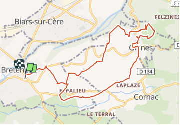
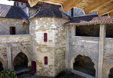
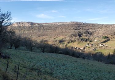
Trail Walking of 12.6 km to be discovered at Occitania, Lot, Bretenoux. This trail is proposed by viem46.

Description

De Bretenoux autour de Glanes en boucle; magnifiques vues vignoble chateau dordogne et noyers

Elevation profile

Positioning

Country:
France
Region :
Occitania
Department/Province :
Lot
Municipality :
Bretenoux
Location:
Unknown
Start:(UTM)
408462 ; 4973955 (31T) N.

Trails nearby

Trail Walking Prudhomat - autour de castelnau - Photo
Walking
lefrancm

Walking

Very easy
(1)
Prudhomat, Occitania, Lot, France
3.5 km | 4.8 km-effort
1h 48min
No
Trail Walking Loubressac - Loubressac-Château des Anglais - Photo
Walking
werth

Walking

Easy
Loubressac, Occitania, Lot, France
8.6 km | 12.1 km-effort
2h 21min
Yes
Trail Walking Autoire - segonzac autoire - Photo
Walking
bellouelo46

Walking

Easy
Autoire, Occitania, Lot, France
11.9 km | 15.9 km-effort
3h 0min
Yes
Trail Walking Bilhac - mas del pouch par moulin de la force - Photo
Walking
pmuet

Walking

Very easy
(2)
Bilhac, New Aquitaine, Corrèze, France
8.4 km | 10.7 km-effort
2h 18min
Yes
Trail Walking Bretenoux - La Via Arverna (Bretenoux - Carennac) - Photo
Walking
tracegps

Walking

Difficult
Bretenoux, Occitania, Lot, France
31 km | 41 km-effort
9h 0min
No
Trail Walking Loubressac - loubressac - Photo
Walking
vincent35

Walking

Very easy
Loubressac, Occitania, Lot, France
13.4 km | 19 km-effort
4h 24min
Yes
Trail Walking Loubressac - Camping La Garrigue  - Photo
Walking
Gegetop

Walking

Medium
Loubressac, Occitania, Lot, France
14.1 km | 17.5 km-effort
3h 50min
Yes
Trail Nordic walking Loubressac - Loubressac, Autoire, château des anglais.  - Photo
Nordic walking
Gegetop

Nordic walking

Medium
Loubressac, Occitania, Lot, France
12.9 km | 18.9 km-effort
4h 32min
Yes
Trail Walking Saint-Médard-de-Presque - cascade d'Autoire - Photo
Walking
viam19

Walking

Medium
Saint-Médard-de-Presque, Occitania, Lot, France
13.6 km | 18.8 km-effort
5h 54min
Yes


Close
My subscriptions