Trail Mountain bike Carry-le-Rouet - le romaron - Photo
© OpenStreetMap contributors
Length
Length
23 km
Max alt
Max alt
181 m
Uphill gradient
Uphill gradient
394 m
Km-Effort
Km-Effort  
28 km
Min alt
Min alt
2 m
Downhill gradient
Downhill gradient
392 m
Boucle
Boucle
Yes
Creation date :
2014-12-10 00:00:00.0
Updated on :
2014-12-10 00:00:00.0

(0 Reviews)

Mountain bike
Mountain bike
3h11
Difficulty : Medium

Scan this QR Code to open this trail in the SityTrail application

FREE GPS app for hiking

Logo SityTrail SityTrail

IGN / Geographical institutes

Download SityTrail from the App Store Download SityTrail from Google Play

Logo SityTrail SityTrail World

The world is yours!

Download SityTrail from the App Store Download SityTrail from Google Play Download SityTrail on Huawei AppGallery

About

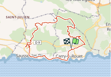
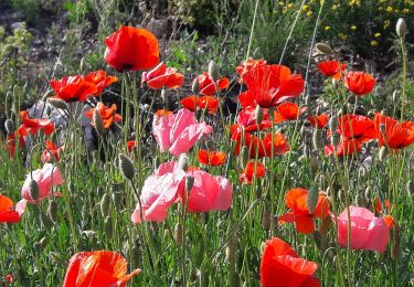
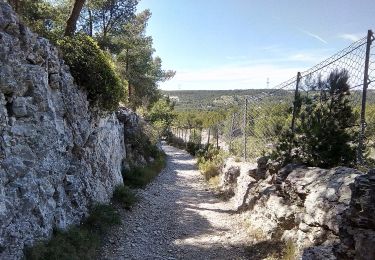
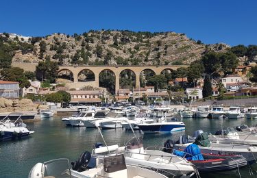
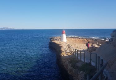
Trail Mountain bike of 23 km to be discovered at Provence-Alpes-Côte d'Azur, Bouches-du-Rhône, Carry-le-Rouet. This trail is proposed by fifidebreizh.

Description

Belle randonnée, beaucoup de cotes, descentes pentues et pierreuses. Guide imprévue entré 3 et 4.

Elevation profile

Photos

Positioning

Country:
France
Region :
Provence-Alpes-Côte d'Azur
Department/Province :
Bouches-du-Rhône
Municipality :
Carry-le-Rouet
Location:
Unknown
Start:(UTM)
674668 ; 4800628 (31T) N.

Trails nearby

Trail On foot Sausset-les-Pins - Mer et Pinéde Valapoux - Photo
On foot
PRO

On foot

Easy
Sausset-les-Pins, Provence-Alpes-Côte d'Azur, Bouches-du-Rhône, France
6.6 km | 7.9 km-effort
1h 47min
Yes
Trail On foot Carry-le-Rouet - Le Vallon de Jaume par les Grottes - Photo
On foot
PRO

On foot

Easy
Carry-le-Rouet, Provence-Alpes-Côte d'Azur, Bouches-du-Rhône, France
7.5 km | 10.2 km-effort
2h 19min
No
Trail On foot Carry-le-Rouet - Le Tour du Romaron - Photo
On foot
PRO

On foot

Easy
Carry-le-Rouet, Provence-Alpes-Côte d'Azur, Bouches-du-Rhône, France
7.3 km | 10 km-effort
2h 15min
No
Trail On foot Carry-le-Rouet - Entre calanques et collines - Photo
On foot
PRO

On foot

Easy
Carry-le-Rouet, Provence-Alpes-Côte d'Azur, Bouches-du-Rhône, France
11.8 km | 14.6 km-effort
3h 19min
No
Trail On foot Sausset-les-Pins - Grand Vallat - Littoral - Photo
On foot
PRO

On foot

Easy
Sausset-les-Pins, Provence-Alpes-Côte d'Azur, Bouches-du-Rhône, France
4.9 km | 5.9 km-effort
1h 20min
Yes
Trail On foot Ensuès-la-Redonne - Grand Sentier de la Côte Bleue - Photo
On foot
PRO

On foot

Very difficult
Ensuès-la-Redonne, Provence-Alpes-Côte d'Azur, Bouches-du-Rhône, France
50 km | 60 km-effort
13h 34min
No
Trail On foot Martigues - Mer et colline Valestéloué - Photo
On foot
PRO

On foot

Easy
Martigues, Provence-Alpes-Côte d'Azur, Bouches-du-Rhône, France
14.5 km | 17.8 km-effort
4h 2min
Yes
Trail Walking Ensuès-la-Redonne - La Redonne - Calanques des Anthénors et de Figuières - Photo
Walking
patjobou

Walking

Medium
Ensuès-la-Redonne, Provence-Alpes-Côte d'Azur, Bouches-du-Rhône, France
4.6 km | 6.7 km-effort
1h 46min
Yes
Trail Walking Carry-le-Rouet - L'Estaque - Le Sentier du Lézard  - Photo
Walking
patjobou

Walking

Easy
Carry-le-Rouet, Provence-Alpes-Côte d'Azur, Bouches-du-Rhône, France
4.9 km | 5.7 km-effort
1h 24min
Yes


Close
My subscriptions