Trail Walking Montcarra - Sur les hauteurs de Montcarra - Photo

Sur les hauteurs de Montcarra

 frdy69
frdy69

User

© OpenStreetMap contributors
Length
Length
6.8 km
Max alt
Max alt
436 m
Uphill gradient
Uphill gradient
87 m
Km-Effort
Km-Effort  
8 km
Min alt
Min alt
356 m
Downhill gradient
Downhill gradient
87 m
Boucle
Boucle
Yes
Creation date :
2014-12-10 00:00:00.0
Updated on :
2014-12-10 00:00:00.0

(1 Reviews)

Walking
Walking
1h44
Difficulty : Easy

Scan this QR Code to open this trail in the SityTrail application

FREE GPS app for hiking

Logo SityTrail SityTrail

IGN / Geographical institutes

Download SityTrail from the App Store Download SityTrail from Google Play

Logo SityTrail SityTrail World

The world is yours!

Download SityTrail from the App Store Download SityTrail from Google Play Download SityTrail on Huawei AppGallery

About

Trail Walking of 6.8 km to be discovered at Auvergne-Rhône-Alpes, Isère, Montcarra. This trail is proposed by frdy69.

Description

Balade permettant d'avoir une jolie vue a 360° sur les massifs de la région par temps clair.
         

Elevation profile

Positioning

Country:
France
Region :
Auvergne-Rhône-Alpes
Department/Province :
Isère
Municipality :
Montcarra
Location:
Unknown
Start:(UTM)
686705 ; 5053781 (31T) N.

Comments

Please log in to post a review or rate the element


Trails nearby

Trail Walking Saint-Chef - Promenade 2022/02/13 - Photo
Walking
bertrand.gillet

Walking

Medium
Saint-Chef, Auvergne-Rhône-Alpes, Isère, France
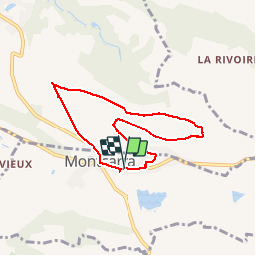
6.9 km | 8.9 km-effort
1h 23min
Yes
Trail Walking Saint-Chef - Randonnée autour de Saint Chef - Photo
Walking
tracegps

Walking

Easy
(1)
Saint-Chef, Auvergne-Rhône-Alpes, Isère, France
10.3 km | 12.4 km-effort
3h 45min
Yes
Trail Walking Vignieu - Vignieu - Saint Chef - Canal des moines  - Photo
Walking

Walking

Very difficult
Vignieu, Auvergne-Rhône-Alpes, Isère, France
15.6 km | 20 km-effort
4h 34min
Yes
Trail Quad Saint-Clair-de-la-Tour - Remise en forme de printemps  - Photo
Quad
lescimes260

Quad

Easy
Saint-Clair-de-la-Tour, Auvergne-Rhône-Alpes, Isère, France
80 km | 105 km-effort
4h 11min
No
Trail Walking Saint-Chef - Courses Saint-Chef - 20220222 - Photo
Walking
bertrand.gillet

Walking

Easy
Saint-Chef, Auvergne-Rhône-Alpes, Isère, France
4.4 km | 5 km-effort
45min
Yes
Trail Walking Cessieu - Cessiez - Photo
Walking
alphonse22

Walking

Cessieu, Auvergne-Rhône-Alpes, Isère, France
5.5 km | 7.3 km-effort
2h 11min
No
Trail Walking Saint-Chef - Saint chef 2 - Photo
Walking
cacrhone

Walking

Very easy
Saint-Chef, Auvergne-Rhône-Alpes, Isère, France
9.6 km | 12.5 km-effort
3h 3min
Yes
Trail Walking Vézeronce-Curtin - Vignieu - Photo
Walking
cricri34

Walking

Medium
Vézeronce-Curtin, Auvergne-Rhône-Alpes, Isère, France
11.7 km | 15.4 km-effort
3h 18min
Yes
Trail Walking Saint-Jean-de-Soudain - 2013 09 15 St-Jean de Soudain - Photo
Walking
lechner

Walking

Very easy
Saint-Jean-de-Soudain, Auvergne-Rhône-Alpes, Isère, France
16.7 km | 20 km-effort
1h 14min
Yes


Close
My subscriptions