Trail Walking Habère-Poche - Mont Forchat - Habère Poche - Ramble - Photo

Mont Forchat - Habère Poche - Ramble

 tracegps
tracegps

User

© OpenStreetMap contributors
Length
Length
10.7 km
Max alt
Max alt
1524 m
Uphill gradient
Uphill gradient
590 m
Km-Effort
Km-Effort  
18.6 km
Min alt
Min alt
1061 m
Downhill gradient
Downhill gradient
589 m
Boucle
Boucle
Yes
Creation date :
2014-12-10 00:00:00.0
Updated on :
2014-12-10 00:00:00.0

(2 Reviews)

Walking
Walking
4h00
Difficulty : Medium

Scan this QR Code to open this trail in the SityTrail application

FREE GPS app for hiking

Logo SityTrail SityTrail

IGN / Geographical institutes

Download SityTrail from the App Store Download SityTrail from Google Play

Logo SityTrail SityTrail World

The world is yours!

Download SityTrail from the App Store Download SityTrail from Google Play Download SityTrail on Huawei AppGallery

About

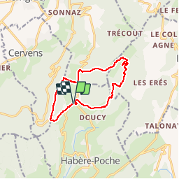
Trail Walking of 10.7 km to be discovered at Auvergne-Rhône-Alpes, Upper Savoy, Habère-Poche. This trail is proposed by tracegps.

Description

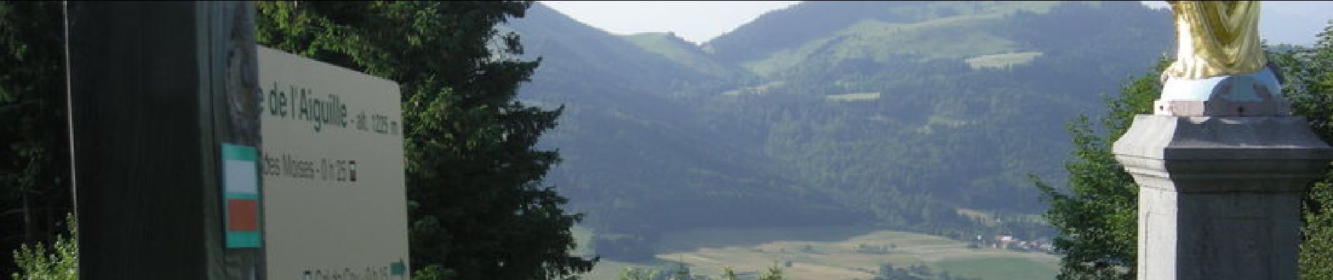
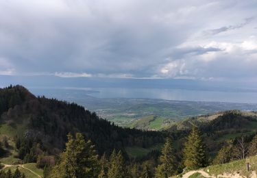
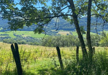
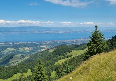
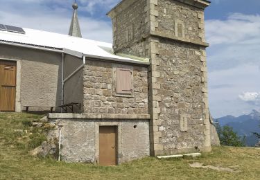
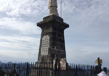
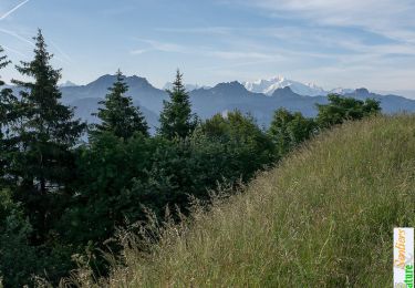
Départ de Ramble au parking situé juste après l'intersection entre la D12 allant au col de Cou et la D246 qui mène au col des Moises. Prendre la D246 près du terrain de tennis, puis l'abandonner après environ 350m en empruntant le large chemin non revêtu qui part sur la droite en direction des Granges Mamet. La montée vers le col de l'Encrenaz (ou de l'Incarne en local) commence véritablement au creux de ce thalweg, juste après avoir quitter le large chemin qui conduit au col des Arces sur l'autre versant. Arrivé au col, la vue s'ouvre largement vers le Léman et l'alpage de Très le Mont, ainsi que vers le sommet du Forchat sur la droite où vous attend la statue de Saint François de Sales, point culminant du circuit. La poursuite s'effectue en direction du Nord/Nord-Est par un chemin ombragé à cheval sur l'arrête qui conduit à une petite chapelle également dédiée à Saint François de Salles, là où débute véritablement la descente vers Très le Mont. On retrouve à ce niveau le chemin qui monte au col de l'Encrenaz (en sens inverse) pour l'abandonner en empruntant le thalweg descendant qui s'amorce ici, en direction du col des Moises que l'on rejoint par un chemin ombragé de 1,7km en forêt à flanc de coteau. On emprunte dès lors, sur la gauche, la route du col Moises sur environ 500m jusqu'au niveau du bout de piste de vol à voile. A ce stade, les plus fatigués pourront rejoindre le point de départ par la route. Les plus aguerris poursuivront vers le col de Cou par le balcon du Léman, en remontant (dénivellation de 55m) par le chemin en bout de piste conduisant à l'arrête située sur le versant opposé. Poursuite sur l'arrête qui conduit à la vierge de l'Aiguille dominant le col de Cou, duquel on boucle vers le point de départ en empruntant la route.

Elevation profile

Photos

Points of interest

Point of interest Glières-Val-de-Borne - Ph1730 - Photo
tracegps
GLIÈRES-VAL-DE-BORNE 
Point of interest Glières-Val-de-Borne - Ph2046 - Photo
tracegps
GLIÈRES-VAL-DE-BORNE 
Point of interest Glières-Val-de-Borne - Ph2047 - Photo
tracegps
GLIÈRES-VAL-DE-BORNE 
Point of interest Glières-Val-de-Borne - Ph2048 - Photo
tracegps
GLIÈRES-VAL-DE-BORNE 
Point of interest Glières-Val-de-Borne - Ph2049 - Photo
tracegps
GLIÈRES-VAL-DE-BORNE 
Point of interest Lullin - Ph2681 - Photo
tracegps
LULLIN 
Point of interest Lullin - Ph2684 - Photo
tracegps
LULLIN 
Point of interest Lullin - Ph2690 - Photo
tracegps
LULLIN 
Point of interest Lullin - Ph2708 - Photo
tracegps
LULLIN 
Point of interest Lullin - Ph2715 - Photo
tracegps
LULLIN 
Point of interest Lullin - Ph2716 - Photo
tracegps
LULLIN 
Point of interest Lullin - Ph2717 - Photo
tracegps
LULLIN 
Point of interest Lullin - Ph2722 - Photo
tracegps
LULLIN 
Point of interest Lullin - Ph2723 - Photo
tracegps
LULLIN 
Point of interest Lullin - Ph2724 - Photo
tracegps
LULLIN 
Point of interest Draillant - Ph2726 - Photo
tracegps
DRAILLANT 
Point of interest Habère-Poche - Ph2730 - Photo
tracegps
HABÈRE-POCHE 
Point of interest Habère-Poche - Ph2734 - Photo
tracegps
HABÈRE-POCHE 
Point of interest Habère-Poche - Ph2735 - Photo
tracegps
HABÈRE-POCHE 

Positioning

Country:
France
Region :
Auvergne-Rhône-Alpes
Department/Province :
Upper Savoy
Municipality :
Habère-Poche
Location:
Unknown
Start:(UTM)
304685 ; 5126950 (32T) N.

Comments

Please log in to post a review or rate the element


super chemin merci


Trails nearby

Trail Walking Habère-Poche - Le mont forchat  - Photo
Walking
colomb24

Walking

Very difficult
Habère-Poche, Auvergne-Rhône-Alpes, Upper Savoy, France
12.4 km | 19.9 km-effort
6h 49min
Yes
Trail Walking Lullin - Le Mont Forchat au départ du col des Arses - Photo
Walking
reneperrin

Walking

Medium
Lullin, Auvergne-Rhône-Alpes, Upper Savoy, France
4.2 km | 8.9 km-effort
1h 20min
Yes
Trail Walking Habère-Poche - Rando VV - Photo
Walking
thierry.berthouze

Walking

Medium
Habère-Poche, Auvergne-Rhône-Alpes, Upper Savoy, France
13.4 km | 19.1 km-effort
3h 39min
No
Trail Walking Lullin - M'ONT FORCHAT 5 JUILLET 2022  - Photo
Walking
med88

Walking

Medium
Lullin, Auvergne-Rhône-Alpes, Upper Savoy, France
5.1 km | 7.9 km-effort
1h 31min
Yes
Trail Walking Lullin - col du fey - Photo
Walking
atmosphil

Walking

Medium
Lullin, Auvergne-Rhône-Alpes, Upper Savoy, France
7.2 km | 11.8 km-effort
2h 56min
Yes
Trail Walking Sciez - forêt de sciez - Photo
Walking
Vanille Fleur

Walking

Very easy
Sciez, Auvergne-Rhône-Alpes, Upper Savoy, France
3.8 km | 4.5 km-effort
1h 16min
Yes
Trail Walking Habère-Lullin - Reco rando G3 La crête Mirmentaz 16-05 - Photo
Walking
Arthurjcm

Walking

Medium
Habère-Lullin, Auvergne-Rhône-Alpes, Upper Savoy, France
13.3 km | 24 km-effort
6h 28min
Yes
Trail Mountain bike Habère-Poche - rando VTT Habere Poche 2017 - Photo
Mountain bike
leclaude74

Mountain bike

Very difficult
Habère-Poche, Auvergne-Rhône-Alpes, Upper Savoy, France
71 km | 105 km-effort
6h 20min
Yes
Trail Walking Draillant - Le Mont Forchat, 1539m - Habère Lullin - Photo
Walking
tracegps

Walking

Medium
(2)
Draillant, Auvergne-Rhône-Alpes, Upper Savoy, France
7.4 km | 13.6 km-effort
3h 15min
Yes


Close
My subscriptions