Trail Walking Passy - Lachat d'en Haut - Passy Plateau d'Assy - Photo

Lachat d'en Haut - Passy Plateau d'Assy

 tracegps
tracegps

User

© OpenStreetMap contributors
Length
Length
10.8 km
Max alt
Max alt
1684 m
Uphill gradient
Uphill gradient
850 m
Km-Effort
Km-Effort  
22 km
Min alt
Min alt
961 m
Downhill gradient
Downhill gradient
850 m
Boucle
Boucle
Yes
Creation date :
2014-12-10 00:00:00.0
Updated on :
2014-12-10 00:00:00.0

(0 Reviews)

Walking
Walking
3h00
Difficulty : Medium

Scan this QR Code to open this trail in the SityTrail application

FREE GPS app for hiking

Logo SityTrail SityTrail

IGN / Geographical institutes

Download SityTrail from the App Store Download SityTrail from Google Play

Logo SityTrail SityTrail World

The world is yours!

Download SityTrail from the App Store Download SityTrail from Google Play Download SityTrail on Huawei AppGallery

About

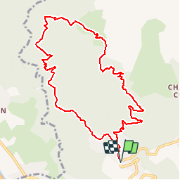
Trail Walking of 10.8 km to be discovered at Auvergne-Rhône-Alpes, Upper Savoy, Passy. This trail is proposed by tracegps.

Description

Au départ de Bayn montez dans le village jusqu’au Coudray, suivre la direction Zéta (piste de Varan au début). Après Zéta, continuez vers Lachat d’en Haut. Descente par un sentier raide jusqu’à Lachat d’en Bas, la Trappe, Hauteville et Bay.

Elevation profile

Photos

Positioning

Country:
France
Region :
Auvergne-Rhône-Alpes
Department/Province :
Upper Savoy
Municipality :
Passy
Location:
Unknown
Start:(UTM)
319994 ; 5089086 (32T) N.

Trails nearby

Trail Walking Passy - Tour des Ayères - Passy Plaine-Joux - Photo
Walking
tracegps

Walking

Medium
(6)
Passy, Auvergne-Rhône-Alpes, Upper Savoy, France
9 km | 14.3 km-effort
2h 30min
Yes
Trail Walking Passy - Plaine Joux Barmus Ayères Lac Vert  - Photo
Walking
GUIDE
Kargil

Walking

Very easy
(1)
Passy, Auvergne-Rhône-Alpes, Upper Savoy, France
7.6 km | 12.2 km-effort
2h 18min
Yes
Trail Walking Sallanches - arpenaz - Photo
Walking
balmesc

Walking

Easy
(3)
Sallanches, Auvergne-Rhône-Alpes, Upper Savoy, France
7 km | 8.7 km-effort
2h 35min
Yes
Trail Walking Passy - Tour de la chaine des Fiz par le passage du Dérochoir - Photo
Walking
tracegps

Walking

Very difficult
(1)
Passy, Auvergne-Rhône-Alpes, Upper Savoy, France
47 km | 90 km-effort
18h 0min
Yes
Trail Walking Passy - Plaine Joux-Passage du derochoir-Col de Portette-Platé - Photo
Walking
GUIDE
Kargil

Walking

Difficult
Passy, Auvergne-Rhône-Alpes, Upper Savoy, France
14.4 km | 30 km-effort
6h 42min
Yes
Trail Running Passy - grimpe de chedde ayeres - Photo
Running
winbat11

Running

Very easy
(1)
Passy, Auvergne-Rhône-Alpes, Upper Savoy, France
15 km | 28 km-effort
2h 46min
No
Trail Walking Saint-Gervais-les-Bains - LE PRARION  - Photo
Walking
joelinou

Walking

Very difficult
Saint-Gervais-les-Bains, Auvergne-Rhône-Alpes, Upper Savoy, France
12.3 km | 23 km-effort
5h 28min
Yes
Trail Touring skiing Combloux - Combloux Croix de Sales - Photo
Touring skiing
janussity

Touring skiing

Medium
Combloux, Auvergne-Rhône-Alpes, Upper Savoy, France
8.1 km | 15.1 km-effort
1h 46min
No
Trail Walking Passy - SIXT PASSY RESERVE: PLAINE JOUX- LAC DE PORMENAZ - REFUGE DE MOEDE ANTERNE - retour par la piste - Photo
Walking
djeepee74

Walking

Difficult
Passy, Auvergne-Rhône-Alpes, Upper Savoy, France
16.7 km | 28 km-effort
5h 34min
Yes


Close
My subscriptions