Trail Walking Flaux - Entre la Capelle et St Victor - Flaux - Photo

Entre la Capelle et St Victor - Flaux

 tracegps
tracegps

User

© OpenStreetMap contributors
Length
Length
18.1 km
Max alt
Max alt
253 m
Uphill gradient
Uphill gradient
337 m
Km-Effort
Km-Effort  
23 km
Min alt
Min alt
136 m
Downhill gradient
Downhill gradient
337 m
Boucle
Boucle
Yes
Creation date :
2014-12-10 00:00:00.0
Updated on :
2014-12-10 00:00:00.0

(0 Reviews)

Walking
Walking
5h00
Difficulty : Medium

Scan this QR Code to open this trail in the SityTrail application

FREE GPS app for hiking

Logo SityTrail SityTrail

IGN / Geographical institutes

Download SityTrail from the App Store Download SityTrail from Google Play

Logo SityTrail SityTrail World

The world is yours!

Download SityTrail from the App Store Download SityTrail from Google Play Download SityTrail on Huawei AppGallery

About

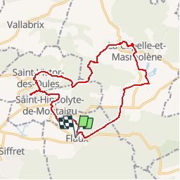
Trail Walking of 18.1 km to be discovered at Occitania, Gard, Flaux. This trail is proposed by tracegps.

Description

Balade facile sur de bons chemins balisés d'un village a l'autre. 18km en terrain vallonné. Cette trace débute au village de Flaux , mais le départ peut être de n'importe quel des villages du parcours. Partir vers le cimetière et cheminer dans les vignobles. Traverser St Hippolyte de Montaigu, monter a gauche vers le Montaigu ,escalader les rochers pour profiter de la vue ; retourner sur ses pas et descendre à St Victor les Oules , monter dans le village, redescendre vers les carrières pour gagner Masmolène. En haut du village prendre le sentier botanique (suivre attentivement le balisage jaune avec point noir) puis le labyrinthe des blocs de grès, déboucher dans la Capelle, aller vers l'étang, et retourner à Flaux. Bonne rando

Elevation profile

Photos

Positioning

Country:
France
Region :
Occitania
Department/Province :
Gard
Municipality :
Flaux
Location:
Unknown
Start:(UTM)
620567 ; 4875274 (31T) N.

Trails nearby

Trail Walking Argilliers - Les Darbounelles - Argilliers - Photo
Walking
tracegps

Walking

Medium
(1)
Argilliers, Occitania, Gard, France
11.4 km | 13.9 km-effort
3h 0min
Yes
Trail Running Saint-Maximin - St-Maximin et la vallée d'Eure - Photo
Running
tracegps

Running

Medium
(1)
Saint-Maximin, Occitania, Gard, France
18 km | 23 km-effort
2h 0min
Yes
Trail Walking La Capelle-et-Masmolène - Masmolène et l'étang de la Capelle - Photo
Walking
jesusmarieclaire

Walking

Very easy
(1)
La Capelle-et-Masmolène, Occitania, Gard, France
14.4 km | 16.8 km-effort
3h 37min
No
Trail Walking Saint-Siffret - au départ de St Siffrey - Photo
Walking
GUIDE
nadinebondoux

Walking

Medium
Saint-Siffret, Occitania, Gard, France
18.2 km | 22 km-effort
5h 27min
Yes
Trail Walking La Capelle-et-Masmolène - La Capelle-et-Masmolène - Photo
Walking
Gegetop

Walking

Easy
La Capelle-et-Masmolène, Occitania, Gard, France
7.7 km | 9.1 km-effort
2h 8min
Yes
Trail Walking La Capelle-et-Masmolène - la Capelle Masmolène - Photo
Walking
GUIDE
nadinebondoux

Walking

Medium
La Capelle-et-Masmolène, Occitania, Gard, France
16.8 km | 21 km-effort
5h 45min
Yes
Trail Walking Argilliers - Argiiliers   les Darbounelles - Photo
Walking
Manoune

Walking

Easy
Argilliers, Occitania, Gard, France
13.6 km | 16.7 km-effort
4h 35min
Yes
Trail Mountain bike La Capelle-et-Masmolène - 30-vtt-lacapelle-St-Siffret-25km-230m-juin21 - Photo
Mountain bike
SyMA

Mountain bike

Medium
La Capelle-et-Masmolène, Occitania, Gard, France
25 km | 28 km-effort
2h 41min
Yes
Trail Walking La Capelle-et-Masmolène - 30-lacapelle-forets-15km-240m-juin21 - Photo
Walking
SyMA

Walking

Medium
La Capelle-et-Masmolène, Occitania, Gard, France
14.9 km | 18.1 km-effort
3h 37min
Yes


Close
My subscriptions