Trail Walking Marolles-les-Buis - Maquis de Plainville Part1 8.5 Km - Photo

Maquis de Plainville Part1 8.5 Km

 ODDAD78
ODDAD78

User

© OpenStreetMap contributors
Length
Length
8.5 km
Max alt
Max alt
275 m
Uphill gradient
Uphill gradient
168 m
Km-Effort
Km-Effort  
10.8 km
Min alt
Min alt
161 m
Downhill gradient
Downhill gradient
168 m
Boucle
Boucle
Yes
Creation date :
2019-04-13 16:36:32.302
Updated on :
2019-04-13 16:36:32.335

(0 Reviews)

Walking
Walking
2h25
Difficulty : Easy

Scan this QR Code to open this trail in the SityTrail application

FREE GPS app for hiking

Logo SityTrail SityTrail

IGN / Geographical institutes

Download SityTrail from the App Store Download SityTrail from Google Play

Logo SityTrail SityTrail World

The world is yours!

Download SityTrail from the App Store Download SityTrail from Google Play Download SityTrail on Huawei AppGallery

About

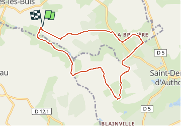
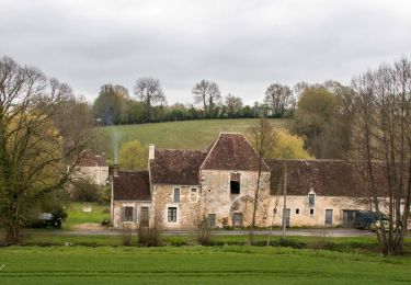
Trail Walking of 8.5 km to be discovered at Centre-Loire Valley, Eure-et-Loir, Marolles-les-Buis. This trail is proposed by ODDAD78.

Description

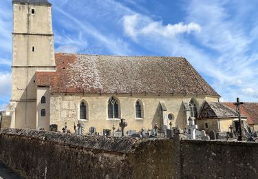
Poinr de départ à la Chapelle Sainte Barbe (près des Rieux)
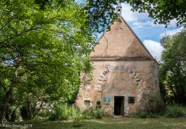
S'arrêter à la petite Chapelle de St Hilaire des noyers.
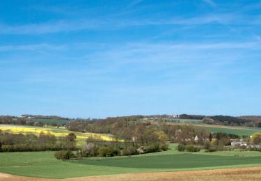
Plus aisé de partir de Plainville : place pour garer les voitures

Elevation profile

Positioning

Country:
France
Region :
Centre-Loire Valley
Department/Province :
Eure-et-Loir
Municipality :
Marolles-les-Buis
Location:
Unknown
Start:(UTM)
347485 ; 5358001 (31U) N.

Trails nearby

Trail Walking Arcisses - Coudreceau, les panoramas du Perche Eurélien 9,4 km - Photo
Walking
ODDAD78

Walking

Medium
Arcisses, Centre-Loire Valley, Eure-et-Loir, France
9.4 km | 11.4 km-effort
2h 35min
Yes
Trail Walking Arcisses - Brunelles - Autour du Promontoire 10 km - Photo
Walking
ODDAD78

Walking

Medium
Arcisses, Centre-Loire Valley, Eure-et-Loir, France
10.1 km | 11.6 km-effort
2h 37min
Yes
Trail Walking Arcisses - 2023-04-24_20h15m45_Ozée  9,1 km - Photo
Walking
ODDAD78

Walking

Medium
(1)
Arcisses, Centre-Loire Valley, Eure-et-Loir, France
9.1 km | 11.2 km-effort
2h 32min
Yes
Trail Walking Marolles-les-Buis - SityTrail - Le hameau de la Cloche 7,4 km - Photo
Walking
ODDAD78

Walking

Medium
Marolles-les-Buis, Centre-Loire Valley, Eure-et-Loir, France
8.1 km | 10.4 km-effort
2h 21min
Yes
Trail Walking Arcisses - Coudreceau - Saint-Victor-de-Buthon 11 km - Photo
Walking

Walking

Easy
Arcisses, Centre-Loire Valley, Eure-et-Loir, France
11.6 km | 14.3 km-effort
3h 6min
No
Trail Walking Arcisses - Coudreceau - Nogent-le-Rotrou 11 km - Photo
Walking

Walking

Easy
Arcisses, Centre-Loire Valley, Eure-et-Loir, France
11.2 km | 13.2 km-effort
5h 23min
No
Trail Walking Arcisses - Coudreceau - Thiron-Gardais 9,2 km - Photo
Walking

Walking

Easy
Arcisses, Centre-Loire Valley, Eure-et-Loir, France
9.2 km | 11 km-effort
5h 23min
No
Trail Walking Arcisses - Rando Brunelles - Photo
Walking
robertserre

Walking

Difficult
Arcisses, Centre-Loire Valley, Eure-et-Loir, France
14.1 km | 16.5 km-effort
2h 37min
Yes
Trail Walking Marolles-les-Buis - 15-JAN-19 16:36:07 - Photo
Walking
ODDAD78

Walking

Easy
Marolles-les-Buis, Centre-Loire Valley, Eure-et-Loir, France
8.5 km | 10.9 km-effort
2h 20min
Yes


Close
My subscriptions