Trail Other activity Vallorbe - Mont d''Or - Région Vallorbe - Photo

Mont d''Or - Région Vallorbe

 Romrando
Romrando

User

© OpenStreetMap contributors
Length
Length
14.4 km
Max alt
Max alt
1454 m
Uphill gradient
Uphill gradient
585 m
Km-Effort
Km-Effort  
22 km
Min alt
Min alt
955 m
Downhill gradient
Downhill gradient
584 m
Boucle
Boucle
Yes
Creation date :
2014-12-11 00:00:00.0
Updated on :
2014-12-11 00:00:00.0

(0 Reviews)

Other activity
Other activity
--
Difficulty : Unknown

Scan this QR Code to open this trail in the SityTrail application

FREE GPS app for hiking

Logo SityTrail SityTrail

IGN / Geographical institutes

Download SityTrail from the App Store Download SityTrail from Google Play

Logo SityTrail SityTrail World

The world is yours!

Download SityTrail from the App Store Download SityTrail from Google Play Download SityTrail on Huawei AppGallery

About

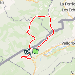
Trail Other activity of 14.4 km to be discovered at Vaud, District du Jura-Nord vaudois, Vallorbe. This trail is proposed by Romrando.

Description

Source:geocities.com/romrando

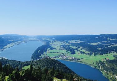
Très beau parcours forestier peu fréquenté et vues remarquables le long de la crête du Mont-d''Or.

Parquer la voiture 3 km à l''W de Vallorbe sur la route qui mène au Pont, 100m avant la première épingle à gauche.

Emprunter la route forestière vers l''W sur 1 km puis à un carrefour prendre une nouvelle route ver l''E qui mène à la frontière, juste avant la "Petite Echelle".

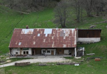
Sans franchir la frontière prendre à droite un chemin forestier qui monte direction NE vers le chalet de la "Combe Baratoux puis suivre un enchainement de clairère en suivant la ligne de crête puis en petite combe jusqu''à "Pralioux-Dessus". Vers le N on gagne la cabane CAS du Mont d''Or puis on s''engage le long de la falaise. (Brouillard = Danger !).

Souvent soufflée elle reste en principe pratiquable près du bord, mais attention aux corniches parfois importantes (Prudence !!!). Suivre la falaise environ 1,5 km puis peu avant d''atteindre le sommet des premiers téléskis, descendre vers l''W par une route sur "La Grangette" (Restaurant).

Poursuivre vers le S toujours par la route ou la piste tracée vers "La Coquille" puis "La Roulette". Partir vers le SE sur la "Grande Echelle" puis descendre sur la "Petite Echelle et rejoindre la frontière. Retour par le même itinéraire.

Elevation profile

Positioning

Country:
Switzerland
Region :
Vaud
Department/Province :
District du Jura-Nord vaudois
Municipality :
Vallorbe
Location:
Unknown
Start:(UTM)
296259 ; 5175288 (32T) N.

Trails nearby

Trail Mountain bike Vallorbe - Le Suchet - Photo
Mountain bike
GUIDE+

Mountain bike

Very easy
(1)
Vallorbe, Vaud, District du Jura-Nord vaudois, Switzerland
35 km | 53 km-effort
14h 41min
Yes
Trail On foot Vallorbe - Mont d'Orzeires - Le Pont Gare - Photo
On foot
PRO

On foot

Easy
Vallorbe, Vaud, District du Jura-Nord vaudois, Switzerland
3.2 km | 4.4 km-effort
59min
No
Trail On foot L'Abbaye - Pétra Félix-Dent du Vaulion - Photo
On foot
PRO

On foot

Easy
L'Abbaye, Vaud, District du Jura-Nord vaudois, Switzerland
3.1 km | 6.3 km-effort
1h 25min
No
Trail On foot Vallorbe - Saigne Geret-Les Revines - Photo
On foot
PRO

On foot

Easy
Vallorbe, Vaud, District du Jura-Nord vaudois, Switzerland
3.5 km | 4.1 km-effort
56min
No
Trail Walking L'Abbaye - La Dent de Vaulion - Photo
Walking
drarep

Walking

Very difficult
(1)
L'Abbaye, Vaud, District du Jura-Nord vaudois, Switzerland
14.6 km | 22 km-effort
4h 31min
Yes
Trail Walking Rochejean - Mont d'or  - Photo
Walking
eltonnermou

Walking

Easy
Rochejean, Bourgogne-Franche-Comté, Doubs, France
11.9 km | 17.5 km-effort
4h 53min
Yes
Trail Walking Jougne - La Jougnena - Photo
Walking
daniellebou

Walking

Very difficult
(1)
Jougne, Bourgogne-Franche-Comté, Doubs, France
17.7 km | 24 km-effort
5h 32min
Yes
Trail Snowshoes L'Abbaye - Le Pont dent de Vaulion Suisse - Photo
Snowshoes
janussity

Snowshoes

Very easy
L'Abbaye, Vaud, District du Jura-Nord vaudois, Switzerland
16.1 km | 24 km-effort
4h 20min
Yes
Trail Snowshoes Longevilles-Mont-d'Or - Les Longevilles Mont D'Or CAF - Photo
Snowshoes
TRIMAILLE

Snowshoes

Medium
(1)
Longevilles-Mont-d'Or, Bourgogne-Franche-Comté, Doubs, France
8.4 km | 13 km-effort
8h 27min
Yes


Close
My subscriptions