Trail Cycle Gagnières - malbosc - Photo
© OpenStreetMap contributors
Length
Length
39 km
Max alt
Max alt
518 m
Uphill gradient
Uphill gradient
733 m
Km-Effort
Km-Effort  
49 km
Min alt
Min alt
188 m
Downhill gradient
Downhill gradient
733 m
Boucle
Boucle
Yes
Creation date :
2014-12-10 00:00:00.0
Updated on :
2014-12-10 00:00:00.0

(0 Reviews)

Cycle
Cycle
2h46
Difficulty : Easy

Scan this QR Code to open this trail in the SityTrail application

FREE GPS app for hiking

Logo SityTrail SityTrail

IGN / Geographical institutes

Download SityTrail from the App Store Download SityTrail from Google Play

Logo SityTrail SityTrail World

The world is yours!

Download SityTrail from the App Store Download SityTrail from Google Play Download SityTrail on Huawei AppGallery

About

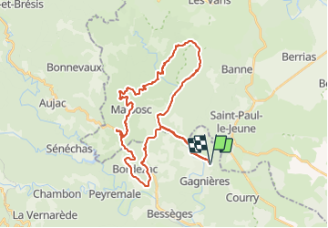
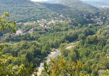
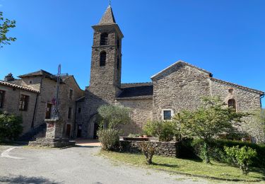
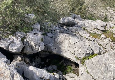
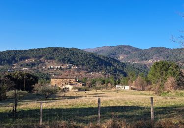
Trail Cycle of 39 km to be discovered at Occitania, Gard, Gagnières. This trail is proposed by cyclopat42600.

Description

Au départ de Gagnières, une petite boucle facile dans les premiers contreforts cévenols.

Elevation profile

Positioning

Country:
France
Region :
Occitania
Department/Province :
Gard
Municipality :
Gagnières
Location:
Unknown
Start:(UTM)
590439 ; 4907633 (31T) N.

Trails nearby

Trail Walking Saint-Paul-le-Jeune - résurgence de cotepatiere ( cocalhere)  - Photo
Walking
silvestreclaudine

Walking

Very easy
(1)
Saint-Paul-le-Jeune, Auvergne-Rhône-Alpes, Ardèche, France
12.9 km | 15.1 km-effort
4h 46min
Yes
Trail Walking Saint-Paul-le-Jeune - Du Viaduc de Doulovy au Fort de Banne - Saint Paul le Jeune - Photo
Walking
tracegps

Walking

Difficult
(2)
Saint-Paul-le-Jeune, Auvergne-Rhône-Alpes, Ardèche, France
16.1 km | 24 km-effort
5h 0min
Yes
Trail Walking Bessèges - GRP Haute Vallée de la Cèze  - Photo
Walking
GUIDE
nadinebondoux

Walking

Very difficult
Bessèges, Occitania, Gard, France
21 km | 36 km-effort
7h 57min
No
Trail Walking Molières-sur-Cèze - moliere sur ceze - Photo
Walking
HILLEBRAND

Walking

Easy
(2)
Molières-sur-Cèze, Occitania, Gard, France
4.6 km | 6.1 km-effort
2h 6min
Yes
Trail Walking Bessèges - Besseges Aujac GR pays - Photo
Walking
GUIDE
Roger Philippe Wallez

Walking

Very difficult
Bessèges, Occitania, Gard, France
23 km | 37 km-effort
10h 3min
No
Trail Walking Saint-André-de-Cruzières - CHADOUILLET - Photo
Walking
asclier0

Walking

Medium
Saint-André-de-Cruzières, Auvergne-Rhône-Alpes, Ardèche, France
7.8 km | 9.4 km-effort
2h 8min
Yes
Trail Walking Bordezac - Les crêtes d'Aujac - Photo
Walking
Levant

Walking

Very difficult
Bordezac, Occitania, Gard, France
22 km | 33 km-effort
6h 17min
Yes
Trail Walking Saint-Paul-le-Jeune - Sentier des dolmens - Photo
Walking
bececoste

Walking

Medium
Saint-Paul-le-Jeune, Auvergne-Rhône-Alpes, Ardèche, France
5.2 km | 6.5 km-effort
1h 40min
Yes
Trail Walking Saint-André-de-Cruzières - 07 chandouillet grotte cotepatiere sauvas peyrejol - Photo
Walking
himba26100

Walking

Medium
Saint-André-de-Cruzières, Auvergne-Rhône-Alpes, Ardèche, France
17.8 km | 24 km-effort
7h 47min
Yes


Close
My subscriptions