Trail Walking Madaillan - Les pieds dans le ruisseau - Photo

Les pieds dans le ruisseau

 jpviau
jpviau

User

© OpenStreetMap contributors
Length
Length
7.2 km
Max alt
Max alt
190 m
Uphill gradient
Uphill gradient
165 m
Km-Effort
Km-Effort  
9.4 km
Min alt
Min alt
87 m
Downhill gradient
Downhill gradient
165 m
Boucle
Boucle
Yes
Creation date :
2015-12-13 00:00:00.0
Updated on :
2015-12-13 00:00:00.0

(0 Reviews)

Walking
Walking
1h58
Difficulty : Very easy

Scan this QR Code to open this trail in the SityTrail application

FREE GPS app for hiking

Logo SityTrail SityTrail

IGN / Geographical institutes

Download SityTrail from the App Store Download SityTrail from Google Play

Logo SityTrail SityTrail World

The world is yours!

Download SityTrail from the App Store Download SityTrail from Google Play Download SityTrail on Huawei AppGallery

About

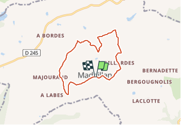
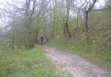
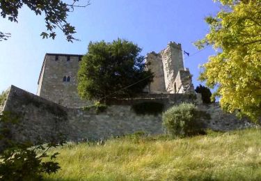
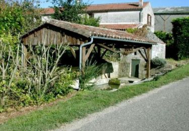
Trail Walking of 7.2 km to be discovered at New Aquitaine, Lot-et-Garonne, Madaillan. This trail is proposed by jpviau.

Elevation profile

Photos

Points of interest

Point of interest Madaillan - Pignon de l'église - Photo
jpviau
Point of interest Madaillan - Risque d'erreur - Photo
jpviau
MADAILLAN 
Point of interest Madaillan - Les pieds dans l'eau - Photo
jpviau

Positioning

Country:
France
Region :
New Aquitaine
Department/Province :
Lot-et-Garonne
Municipality :
Madaillan
Location:
Unknown
Start:(UTM)
306339 ; 4905360 (31T) N.

Trails nearby

Trail Walking Laugnac - De Laugnac  à Cours, un long circuit dans les Serres - Pays de la vallée du Lot - Photo
Walking
tracegps

Walking

Difficult
(2)
Laugnac, New Aquitaine, Lot-et-Garonne, France
21 km | 28 km-effort
5h 15min
Yes
Trail On foot Prayssas - Prayssas, tourisme au pays du chasselas - 9km - Photo
On foot
PRO

On foot

Easy
Prayssas, New Aquitaine, Lot-et-Garonne, France
9 km | 12.3 km-effort
2h 48min
No
Trail Mountain bike Prayssas - Lac de Néguenou à Montpezat - Photo
Mountain bike
tracegps

Mountain bike

Very difficult
Prayssas, New Aquitaine, Lot-et-Garonne, France
43 km | 54 km-effort
4h 0min
Yes
Trail Mountain bike Prayssas - Parcours de Prayssas - Photo
Mountain bike
tracegps

Mountain bike

Very difficult
Prayssas, New Aquitaine, Lot-et-Garonne, France
59 km | 77 km-effort
4h 30min
Yes
Trail Walking Madaillan - Madaillan, le circuit du plateau de Fraisse - Pays de la vallée du Lot - Photo
Walking
tracegps

Walking

Medium
Madaillan, New Aquitaine, Lot-et-Garonne, France
6.8 km | 8.9 km-effort
1h 45min
Yes
Trail Equestrian Lusignan-Petit - Lusignan-Petit, dans les coteaux du Pays de Serres - Pays de la vallée du Lot - Photo
Equestrian
tracegps

Equestrian

Medium
Lusignan-Petit, New Aquitaine, Lot-et-Garonne, France
9.1 km | 12.5 km-effort
1h 30min
Yes
Trail Mountain bike Lusignan-Petit - Lusignan-Petit, dans les coteaux du Pays de Serres - Pays de la vallée du Lot - Photo
Mountain bike
tracegps

Mountain bike

Medium
Lusignan-Petit, New Aquitaine, Lot-et-Garonne, France
9.1 km | 12.5 km-effort
1h 10min
Yes
Trail Walking Lusignan-Petit - Lusignan-Petit, dans les coteaux du Pays de Serres - Pays de la vallée du Lot - Photo
Walking
tracegps

Walking

Medium
Lusignan-Petit, New Aquitaine, Lot-et-Garonne, France
9.1 km | 12.5 km-effort
2h 19min
Yes
Trail Equestrian Lusignan-Petit - Lusignan-Petit vers Prayssas dans les collines du Pays de Serres - Pays de la vallée du Lot - Photo
Equestrian
tracegps

Equestrian

Difficult
Lusignan-Petit, New Aquitaine, Lot-et-Garonne, France
15.1 km | 21 km-effort
2h 40min
Yes


Close
My subscriptions