Trail Walking Lus-la-Croix-Haute - R48 - Gorges des Amayères - Photo

Les Hautes Alpes à découvrir ! GUIDE+

© OpenStreetMap contributors
Length
Length
10.3 km
Max alt
Max alt
1687 m
Uphill gradient
Uphill gradient
529 m
Km-Effort
Km-Effort  
17.5 km
Min alt
Min alt
1158 m
Downhill gradient
Downhill gradient
559 m
Boucle
Boucle
No
Creation date :
2018-08-21 07:49:27.63
Updated on :
2018-11-13 08:42:36.686

(0 Reviews)

Walking
Walking
3h01
Difficulty : Easy

Scan this QR Code to open this trail in the SityTrail application

FREE GPS app for hiking

Logo SityTrail SityTrail

IGN / Geographical institutes

Download SityTrail from the App Store Download SityTrail from Google Play

Logo SityTrail SityTrail World

The world is yours!

Download SityTrail from the App Store Download SityTrail from Google Play Download SityTrail on Huawei AppGallery

About

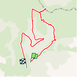
Trail Walking of 10.3 km to be discovered at Auvergne-Rhône-Alpes, Drôme, Lus-la-Croix-Haute. This trail is proposed by Camping Les Rives du Lac.

Description

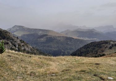
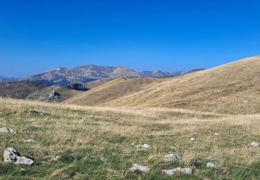
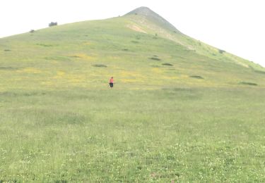
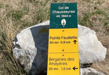
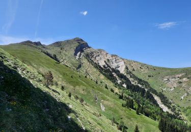
Le vallon des Amayères est splendide. Au départ du village, vous entrez dans de petites gorges dans lesquelles coule un torrent (observez bien, quelques belles truites !). Le sentier s'élève ensuite dans de magnifiques alpages. Au col, nous vous conseillons d'aller jusqu'aux petites falaises à droite (plein Est).

Elevation profile

Photos

Positioning

Country:
France
Region :
Auvergne-Rhône-Alpes
Department/Province :
Drôme
Municipality :
Lus-la-Croix-Haute
Location:
Unknown
Start:(UTM)
714860 ; 4952263 (31T) N.

Trails nearby

Trail Walking Lus-la-Croix-Haute - R38   Col des Aiguilles depuis Lus - Photo
Walking
GUIDE+

Walking

Medium
Lus-la-Croix-Haute, Auvergne-Rhône-Alpes, Drôme, France
5.6 km | 15 km-effort
2h 53min
Yes
Trail Walking Lus-la-Croix-Haute - Le Rognon - Photo
Walking
GAPIAN43

Walking

Medium
(1)
Lus-la-Croix-Haute, Auvergne-Rhône-Alpes, Drôme, France
12.3 km | 22 km-effort
4h 33min
Yes
Trail Walking Glandage - Le Jocou 2 - Photo
Walking
Marco05

Walking

Difficult
Glandage, Auvergne-Rhône-Alpes, Drôme, France
8.5 km | 18.1 km-effort
4h 0min
Yes
Trail Walking Lus-la-Croix-Haute - Pointe Feuillette - Photo
Walking
Marco05

Walking

Difficult
Lus-la-Croix-Haute, Auvergne-Rhône-Alpes, Drôme, France
10.5 km | 20 km-effort
4h 36min
Yes
Trail Walking Lus-la-Croix-Haute - Pointe feuillette  - Photo
Walking
ajd26

Walking

Medium
Lus-la-Croix-Haute, Auvergne-Rhône-Alpes, Drôme, France
11.4 km | 21 km-effort
4h 52min
Yes
Trail Walking Lus-la-Croix-Haute - MAS REBUFAT - POINTE FEUILLETTE  - Photo
Walking
RD78-38

Walking

Medium
Lus-la-Croix-Haute, Auvergne-Rhône-Alpes, Drôme, France
11.7 km | 20 km-effort
3h 33min
Yes
Trail Walking Tréminis - Le col de La Croix - Photo
Walking
dominiq

Walking

Difficult
Tréminis, Auvergne-Rhône-Alpes, Isère, France
8.8 km | 16.5 km-effort
3h 31min
Yes
Trail Walking Lus-la-Croix-Haute - Antécime de La Toussière - Photo
Walking
GuyVachet

Walking

Difficult
Lus-la-Croix-Haute, Auvergne-Rhône-Alpes, Drôme, France
8.6 km | 17.4 km-effort
5h 44min
Yes
Trail Walking Lalley - Serre Motaire et Lazare - Photo
Walking
PapouBertrand

Walking

Very difficult
Lalley, Auvergne-Rhône-Alpes, Isère, France
14.6 km | 24 km-effort
23h 45min
Yes


Close
My subscriptions