


2018-05-08 Marche Gaschney Sentier des Roches

holtzv
User GUIDE
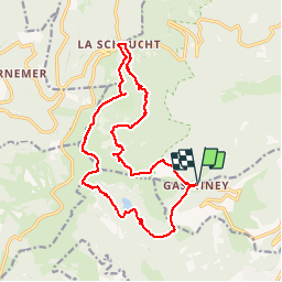

Length
17.5 km

Max alt
1352 m

Uphill gradient
864 m
Km-Effort
29 km

Min alt
923 m

Downhill gradient
865 m
Boucle
Yes
Creation date :
2018-05-08 08:05:27.077
Updated on :
2018-08-23 09:04:31.671
5h52
Difficulty : Very easy

FREE GPS app for hiking
 SityTrail
IGN / Geographical institutes
SityTrail Plus
The world is yours!
About
Trail Walking of 17.5 km to be discovered at Grand Est, Haut-Rhin, Stosswihr. This trail is proposed by holtzv.
Description
Avec les copains de Rosheim Running
Positioning
Country:
France
Region :
Grand Est
Department/Province :
Haut-Rhin
Municipality :
Stosswihr
Location:
Unknown
Start:(Dec)
Start:(UTM)
354439 ; 5321999 (32U) N.
Comments