Trail On foot Bay-sur-Aube - 01 Track-11717-F-MNT - Photo

01 Track-11717-F-MNT

© OpenStreetMap contributors
Length
Length
8 km
Max alt
Max alt
435 m
Uphill gradient
Uphill gradient
224 m
Km-Effort
Km-Effort  
11 km
Min alt
Min alt
315 m
Downhill gradient
Downhill gradient
220 m
Boucle
Boucle
Yes
Creation date :
2019-03-01 14:31:30.902
Updated on :
2020-07-14 12:49:18.217

(0 Reviews)

On foot
On foot
1h50
Difficulty : Very easy

Scan this QR Code to open this trail in the SityTrail application

FREE GPS app for hiking

Logo SityTrail SityTrail

IGN / Geographical institutes

Download SityTrail from the App Store Download SityTrail from Google Play

Logo SityTrail SityTrail World

The world is yours!

Download SityTrail from the App Store Download SityTrail from Google Play Download SityTrail on Huawei AppGallery

About

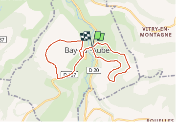
Trail On foot of 8 km to be discovered at Grand Est, Haute-Marne, Bay-sur-Aube. This trail is proposed by Lucienfilippi.

Description

petite rando sans effort au départ de Bay sur Aube
un huit
butte de Taloison et ses pelouses sèches

Elevation profile

Positioning

Country:
France
Region :
Grand Est
Department/Province :
Haute-Marne
Municipality :
Bay-sur-Aube
Location:
Unknown
Start:(UTM)
654645 ; 5298589 (31T) N.

Trails nearby

Trail Cycle Auberive - La Montagne - Auberive - Photo
Cycle
tracegps

Cycle

Difficult
Auberive, Grand Est, Haute-Marne, France
65 km | 80 km-effort
6h 0min
Yes
Trail Walking Auberive - Sentier Vosges-Pyrénées - de Auberive à Grancey le Château - Photo
Walking
tracegps

Walking

Difficult
Auberive, Grand Est, Haute-Marne, France
18.7 km | 25 km-effort
5h 0min
No
Trail Mountain bike Auberive - Le Pont Griselin - Auberive - Photo
Mountain bike
tracegps

Mountain bike

Easy
Auberive, Grand Est, Haute-Marne, France
3.3 km | 3.8 km-effort
19min
Yes
Trail Walking Auberive - Le Pont Griselin - Auberive - Photo
Walking
tracegps

Walking

Very difficult
Auberive, Grand Est, Haute-Marne, France
3.3 km | 3.8 km-effort
1h 0min
Yes
Trail Mountain bike Auberive - Circuit de Montavoir - Auberive - Photo
Mountain bike
tracegps

Mountain bike

Easy
Auberive, Grand Est, Haute-Marne, France
9.1 km | 11.3 km-effort
45min
Yes
Trail Walking Auberive - Circuit de Montavoir - Auberive - Photo
Walking
tracegps

Walking

Easy
Auberive, Grand Est, Haute-Marne, France
9.1 km | 11.3 km-effort
1h 19min
Yes
Trail Mountain bike Auberive - La Tufière d'Amorey - Auberive - Photo
Mountain bike
tracegps

Mountain bike

Easy
Auberive, Grand Est, Haute-Marne, France
10.6 km | 14.2 km-effort
1h 0min
Yes
Trail Walking Auberive - La Tufière d'Amorey - Auberive - Photo
Walking
tracegps

Walking

Easy
Auberive, Grand Est, Haute-Marne, France
10.6 km | 14.2 km-effort
2h 0min
Yes
Trail Mountain bike Bay-sur-Aube - La Butte de Taloison - Bay sur Aube - Photo
Mountain bike
tracegps

Mountain bike

Easy
Bay-sur-Aube, Grand Est, Haute-Marne, France
8 km | 11 km-effort
45min
Yes


Close
My subscriptions