Trail Walking Bassac - Jarnac amont - Photo
 dorcier
dorcier

User

© OpenStreetMap contributors
Length
Length
11.6 km
Max alt
Max alt
30 m
Uphill gradient
Uphill gradient
55 m
Km-Effort
Km-Effort  
12.3 km
Min alt
Min alt
10 m
Downhill gradient
Downhill gradient
55 m
Boucle
Boucle
Yes
Creation date :
2019-04-05 11:52:32.0
Updated on :
2019-04-08 08:33:02.074

(0 Reviews)

Walking
Walking
2h50
Difficulty : Easy

Scan this QR Code to open this trail in the SityTrail application

FREE GPS app for hiking

Logo SityTrail SityTrail

IGN / Geographical institutes

Download SityTrail from the App Store Download SityTrail from Google Play

Logo SityTrail SityTrail World

The world is yours!

Download SityTrail from the App Store Download SityTrail from Google Play Download SityTrail on Huawei AppGallery

About

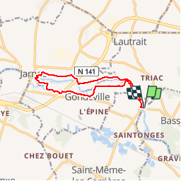
Trail Walking of 11.6 km to be discovered at New Aquitaine, Charente, Bassac. This trail is proposed by dorcier.

Description

Au départ du pont de Vinade cette trace vous conduit à Jarnac en longeant la Charente. Vue sur les châteaux Les Brandes  et St-Martial. Passage dans le site de l’île Madame près de l’écluse de Jarnac. Un départ est possible depuis l'Ile Madame à Jarnac.

Elevation profile

Photos

Positioning

Country:
France
Region :
New Aquitaine
Department/Province :
Charente
Municipality :
Bassac
Location:
Unknown
Start:(UTM)
724353 ; 5061088 (30T) N.

Trails nearby

Trail Cycle Jarnac - Boucle vélo à Jarnac  (23C) - Photo
Cycle
tracegps

Cycle

Medium
Jarnac, New Aquitaine, Charente, France
46 km | 51 km-effort
2h 30min
Yes
Trail Walking Jarnac - Circuit des Pierrères - Jarnac  - Photo
Walking
tracegps

Walking

Difficult
Jarnac, New Aquitaine, Charente, France
13.1 km | 14.8 km-effort
3h 15min
Yes
Trail Walking Graves-Saint-Amant - Graves St Amand 14-07-2016 - Photo
Walking
jmrobin

Walking

Easy
Graves-Saint-Amant, New Aquitaine, Charente, France
14.6 km | 16.6 km-effort
3h 17min
Yes
Trail Other activity Graves-Saint-Amant - bbb - Photo
Other activity
bbubbu

Other activity

Very easy
Graves-Saint-Amant, New Aquitaine, Charente, France
33 km | 37 km-effort
1h 41min
Yes
Trail Walking Vibrac - vibrac  - Photo
Walking
sy!

Walking

Medium
Vibrac, New Aquitaine, Charente, France
8.1 km | 8.6 km-effort
1h 40min
Yes
Trail Walking Jarnac - jarnac - Photo
Walking
chateauvieux59

Walking

Easy
Jarnac, New Aquitaine, Charente, France
3.5 km | 3.7 km-effort
1h 15min
No
Trail Walking Jarnac - GR4-74 - Jarnac - Cognac - Photo
Walking
Tournan

Walking

Very difficult
Jarnac, New Aquitaine, Charente, France
18.2 km | 20 km-effort
4h 30min
No
Trail Walking Angeac-Charente - angeac - Photo
Walking
robertbudd

Walking

Very easy
Angeac-Charente, New Aquitaine, Charente, France
7.7 km | 8.2 km-effort
1h 48min
Yes
Trail Other activity Jarnac - jarnac bourg - Photo
Other activity
destrieux

Other activity

Very easy
Jarnac, New Aquitaine, Charente, France
9 km | 9.6 km-effort
Unknown
Yes


Close
My subscriptions