


LAUZIERE

oliviergau
User
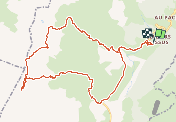

Length
14.7 km

Max alt
2783 m

Uphill gradient
1432 m
Km-Effort
34 km

Min alt
1368 m

Downhill gradient
1437 m
Boucle
Yes
Creation date :
2019-05-12 20:13:19.102
Updated on :
2019-05-12 20:13:19.102
--
Difficulty : Unknown

FREE GPS app for hiking
 SityTrail
IGN / Geographical institutes
SityTrail Plus
The world is yours!
About
Trail Touring skiing of 14.7 km to be discovered at Auvergne-Rhône-Alpes, Savoy, La Léchère. This trail is proposed by oliviergau.
Positioning
Country:
France
Region :
Auvergne-Rhône-Alpes
Department/Province :
Savoy
Municipality :
La Léchère
Location:
Celliers
Start:(Dec)
Start:(UTM)
297725 ; 5038517 (32T) N.
Comments