Trail Touring skiing Tignes - col de la sache et Col de la sachette - Photo

col de la sache et Col de la sachette

 nadd73
nadd73

User

© OpenStreetMap contributors
Length
Length
17.9 km
Max alt
Max alt
2766 m
Uphill gradient
Uphill gradient
1430 m
Km-Effort
Km-Effort  
36 km
Min alt
Min alt
1822 m
Downhill gradient
Downhill gradient
1257 m
Boucle
Boucle
No
Creation date :
2019-05-14 05:31:57.033
Updated on :
2019-05-14 14:24:12.362

(0 Reviews)

Touring skiing
Touring skiing
7h30
Difficulty : Medium

Scan this QR Code to open this trail in the SityTrail application

FREE GPS app for hiking

Logo SityTrail SityTrail

IGN / Geographical institutes

Download SityTrail from the App Store Download SityTrail from Google Play

Logo SityTrail SityTrail World

The world is yours!

Download SityTrail from the App Store Download SityTrail from Google Play Download SityTrail on Huawei AppGallery

About

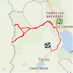
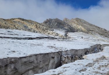
Trail Touring skiing of 17.9 km to be discovered at Auvergne-Rhône-Alpes, Savoy, Tignes. This trail is proposed by nadd73.

Description

départ de Tignes,
Nous devions faire un circuit mais au Col de la Sache trop de corniches.
donc nous descendons comme la montée.
Nous montons au Col de la Sachette
pour la descente jusqu'à la voiture nous avons fait suivant la neige.

Elevation profile

Photos

Positioning

Country:
France
Region :
Auvergne-Rhône-Alpes
Department/Province :
Savoy
Municipality :
Tignes
Location:
Unknown
Start:(UTM)
337634 ; 5040200 (32T) N.

Trails nearby

Trail Walking Tignes - la pointe de Picheru - Photo
Walking
GUIDE
amiral13

Walking

Medium
(1)
Tignes, Auvergne-Rhône-Alpes, Savoy, France
13.8 km | 23 km-effort
5h 36min
Yes
Trail Walking Tignes - l'aiguille perçée - Photo
Walking
GUIDE
amiral13

Walking

Easy
(1)
Tignes, Auvergne-Rhône-Alpes, Savoy, France
5.8 km | 9.8 km-effort
3h 27min
No
Trail Walking Tignes - lacs du saut et de la sassiere - Photo
Walking
GUIDE
amiral13

Walking

Very easy
(3)
Tignes, Auvergne-Rhône-Alpes, Savoy, France
9 km | 12.6 km-effort
3h 56min
Yes
Trail Walking Tignes - Tignes 1800 lac de la Sassièrre aller-retour - Photo
Walking
phdsyn

Walking

Medium
(1)
Tignes, Auvergne-Rhône-Alpes, Savoy, France
28 km | 47 km-effort
1h 0min
Yes
Trail Other activity Tignes - Refuge du Palet Col de la Tourne - Photo
Other activity
demo-tignes

Other activity

Medium
(1)
Tignes, Auvergne-Rhône-Alpes, Savoy, France
11.9 km | 22 km-effort
3h 35min
No
Trail Walking Tignes - boucle Tignes le lac - la daille - Photo
Walking
fav

Walking

Easy
(1)
Tignes, Auvergne-Rhône-Alpes, Savoy, France
14 km | 23 km-effort
2h 56min
Yes
Trail Walking Val-d'Isère - Les cascades des salins au départ de val d’Isère  - Photo
Walking
Klhn

Walking

Medium
(1)
Val-d'Isère, Auvergne-Rhône-Alpes, Savoy, France
9.5 km | 15.2 km-effort
3h 40min
Yes
Trail Walking Tignes - Refuge de la Martin - Photo
Walking
rakapoute

Walking

Medium
(1)
Tignes, Auvergne-Rhône-Alpes, Savoy, France
13.3 km | 26 km-effort
6h 4min
Yes
Trail Walking Tignes - approche glacière de la cime de la Golette - Photo
Walking
GUIDE
amiral13

Walking

Very difficult
Tignes, Auvergne-Rhône-Alpes, Savoy, France
18.5 km | 32 km-effort
8h 29min
Yes


Close
My subscriptions