Trail Mountain bike Blavignac - sur les traces de benoit 46 depuis motocross - Photo

sur les traces de benoit 46 depuis motocross

© OpenStreetMap contributors
Length
Length
39 km
Max alt
Max alt
1108 m
Uphill gradient
Uphill gradient
831 m
Km-Effort
Km-Effort  
51 km
Min alt
Min alt
871 m
Downhill gradient
Downhill gradient
864 m
Boucle
Boucle
No
Creation date :
2019-05-26 09:07:00.967
Updated on :
2019-05-26 11:34:32.39

(0 Reviews)

Mountain bike
Mountain bike
2h00
Difficulty : Medium

Scan this QR Code to open this trail in the SityTrail application

FREE GPS app for hiking

Logo SityTrail SityTrail

IGN / Geographical institutes

Download SityTrail from the App Store Download SityTrail from Google Play

Logo SityTrail SityTrail World

The world is yours!

Download SityTrail from the App Store Download SityTrail from Google Play Download SityTrail on Huawei AppGallery

About

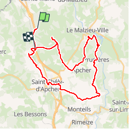
Trail Mountain bike of 39 km to be discovered at Occitania, Lozère, Blavignac. This trail is proposed by kayakiste15.

Description

roulant avec des coups de cul

Elevation profile

Positioning

Country:
France
Region :
Occitania
Department/Province :
Lozère
Municipality :
Blavignac
Location:
Unknown
Start:(UTM)
520727 ; 4967049 (31T) N.

Trails nearby

Trail Mountain bike Les Monts-Verts - Berc - Le Bacon vieux - Trémoulouzet - Photo
Mountain bike
JujuDelfio

Mountain bike

Medium
Les Monts-Verts, Occitania, Lozère, France
11.7 km | 15 km-effort
1h 15min
Yes
Trail Mountain bike Les Monts-Verts - Le Puech de Berc - Photo
Mountain bike
JujuDelfio

Mountain bike

Easy
Les Monts-Verts, Occitania, Lozère, France
8.7 km | 10.9 km-effort
50min
Yes
Trail Mountain bike Les Monts-Verts - Berc - Graniboule - Photo
Mountain bike
JujuDelfio

Mountain bike

Medium
Les Monts-Verts, Occitania, Lozère, France
35 km | 43 km-effort
2h 40min
Yes
Trail Walking Blavignac - Les balcons de la Truyère - Photo
Walking
guitounette

Walking

Very difficult
Blavignac, Occitania, Lozère, France
16.6 km | 26 km-effort
5h 49min
Yes
Trail Electric bike Saint-Chély-d'Apcher - 3_250423 - Photo
Electric bike
ricou1964

Electric bike

Difficult
Saint-Chély-d'Apcher, Occitania, Lozère, France
40 km | 52 km-effort
5h 22min
No
Trail Walking Val d'Arcomie - autour de St Just - Photo
Walking
jfdeligementon

Walking

Very difficult
Val d'Arcomie, Auvergne-Rhône-Alpes, Cantal, France
13.3 km | 19.3 km-effort
4h 22min
Yes
Trail Mountain bike Val d'Arcomie - ST JUST 19 km VTT Loubaresse - Photo
Mountain bike
benoit48

Mountain bike

Very easy
Val d'Arcomie, Auvergne-Rhône-Alpes, Cantal, France
18.9 km | 26 km-effort
1h 18min
Yes
Trail Walking Prunières - Apcher  la Tuyère - Photo
Walking
JEANJOSY

Walking

Very easy
Prunières, Occitania, Lozère, France
16.8 km | 22 km-effort
4h 43min
Yes


Close
My subscriptions