Trail On foot Saint-Andéol-de-Fourchades - 07 St Andéol de Fourchade  - Photo
© OpenStreetMap contributors
Length
Length
17.8 km
Max alt
Max alt
1106 m
Uphill gradient
Uphill gradient
639 m
Km-Effort
Km-Effort  
26 km
Min alt
Min alt
732 m
Downhill gradient
Downhill gradient
639 m
Boucle
Boucle
Yes
Creation date :
2019-05-29 08:20:54.553
Updated on :
2019-05-29 08:27:11.565

(0 Reviews)

On foot
On foot
--
Difficulty : Medium

Scan this QR Code to open this trail in the SityTrail application

FREE GPS app for hiking

Logo SityTrail SityTrail

IGN / Geographical institutes

Download SityTrail from the App Store Download SityTrail from Google Play

Logo SityTrail SityTrail World

The world is yours!

Download SityTrail from the App Store Download SityTrail from Google Play Download SityTrail on Huawei AppGallery

About

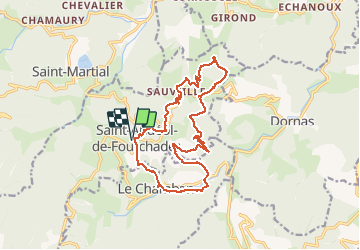
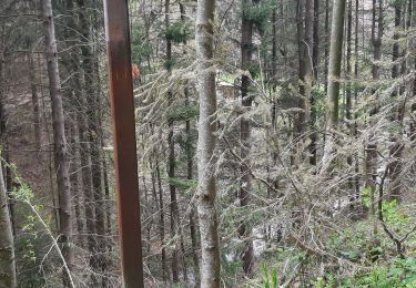
Trail On foot of 17.8 km to be discovered at Auvergne-Rhône-Alpes, Ardèche, Saint-Andéol-de-Fourchades. This trail is proposed by jeanneruols.

Description

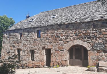
Au SE de St Martial , tracé qui va vers Le Chambon  et qui contourne le Sommet de la Fare , puis on redescend vers le col de Joux

Elevation profile

Positioning

Country:
France
Region :
Auvergne-Rhône-Alpes
Department/Province :
Ardèche
Municipality :
Saint-Andéol-de-Fourchades
Location:
Unknown
Start:(UTM)
602485 ; 4966886 (31T) N.

Trails nearby

Trail Walking Sagnes-et-Goudoulet - Les Coux-Sagnes-Tour à Eau 14km - Photo
Walking
GUIDE
thonyc

Walking

Medium
Sagnes-et-Goudoulet, Auvergne-Rhône-Alpes, Ardèche, France
14.1 km | 19.4 km-effort
5h 42min
Yes
Trail Walking Lachamp-Raphaël - 07 lachamp Raphaël orga 10.06.23 - Photo
Walking
himba26100

Walking

Medium
Lachamp-Raphaël, Auvergne-Rhône-Alpes, Ardèche, France
18 km | 27 km-effort
5h 39min
No
Trail Walking Saint-Martial - Gerbier de Jonc par St Martial - Photo
Walking
jeanneruols

Walking

Saint-Martial, Auvergne-Rhône-Alpes, Ardèche, France
9.2 km | 16.3 km-effort
3h 59min
No
Trail Walking Lachamp-Raphaël - Lachamp-Raphaël :  les sucs - Photo
Walking
bernadette revoux

Walking

Medium
Lachamp-Raphaël, Auvergne-Rhône-Alpes, Ardèche, France
23 km | 31 km-effort
5h 18min
Yes
Trail Walking Dornas - La ronde des hameaux  - Photo
Walking
bernadette revoux

Walking

Difficult
Dornas, Auvergne-Rhône-Alpes, Ardèche, France
18 km | 29 km-effort
5h 4min
Yes
Trail Walking Dornas - la Ronde des hameaux  - Photo
Walking
bernadette revoux

Walking

Difficult
Dornas, Auvergne-Rhône-Alpes, Ardèche, France
23 km | 35 km-effort
5h 35min
Yes
Trail Walking Mézilhac - Mézillac Lachand Raphael - Photo
Walking
leopold.claude

Walking

Very difficult
Mézilhac, Auvergne-Rhône-Alpes, Ardèche, France
16.8 km | 25 km-effort
6h 21min
Yes
Trail Walking Sagnes-et-Goudoulet - Les Coux -  Sagne et Goudoulet - La Tour à Eau 14km - Photo
Walking
chancha

Walking

Difficult
Sagnes-et-Goudoulet, Auvergne-Rhône-Alpes, Ardèche, France
14.2 km | 19.6 km-effort
5h 36min
Yes
Trail Walking Mézilhac - 2022_08_06_Retour rando des Myrtilles  - Photo
Walking
Chamois30

Walking

Easy
Mézilhac, Auvergne-Rhône-Alpes, Ardèche, France
7.1 km | 9 km-effort
2h 0min
No


Close
My subscriptions