Trail Walking Noyers-sur-Jabron - Montagne de Lure (boucle) - Photo
 neitag61
neitag61

User

© OpenStreetMap contributors
Length
Length
12.6 km
Max alt
Max alt
1707 m
Uphill gradient
Uphill gradient
644 m
Km-Effort
Km-Effort  
21 km
Min alt
Min alt
1136 m
Downhill gradient
Downhill gradient
644 m
Boucle
Boucle
Yes
Creation date :
2016-07-12 00:00:00.0
Updated on :
2016-07-12 00:00:00.0

(2 Reviews)

Walking
Walking
4h00
Difficulty : Difficult

Scan this QR Code to open this trail in the SityTrail application

FREE GPS app for hiking

Logo SityTrail SityTrail

IGN / Geographical institutes

Download SityTrail from the App Store Download SityTrail from Google Play

Logo SityTrail SityTrail World

The world is yours!

Download SityTrail from the App Store Download SityTrail from Google Play Download SityTrail on Huawei AppGallery

About

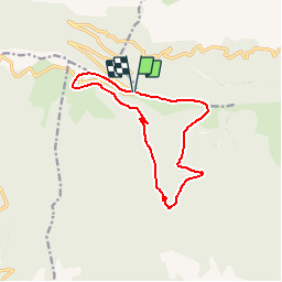
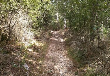
Trail Walking of 12.6 km to be discovered at Provence-Alpes-Côte d'Azur, Alpes-de-Haute-Provence, Noyers-sur-Jabron. This trail is proposed by neitag61.

Description

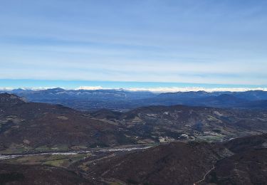
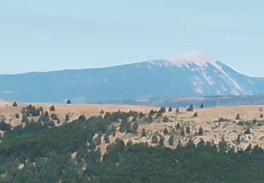
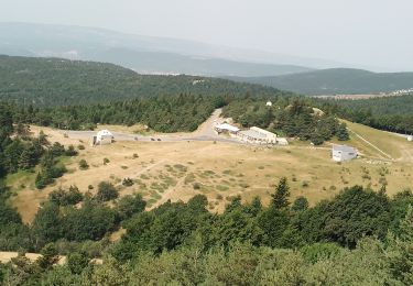
Une magnifique randonnée au départ du Pas de la Graille (petit Parking)
et puis une petite visite au sommet de Lure à partir du parking situé 200m plus bas

Elevation profile

Points of interest

Point of interest Cruis - Unnamed POI - Photo
neitag61
Point of interest Saint-Étienne-les-Orgues - Sommet de LURE - Photo
neitag61
SAINT-ÉTIENNE-LES-ORGUES 

Positioning

Country:
France
Region :
Provence-Alpes-Côte d'Azur
Department/Province :
Alpes-de-Haute-Provence
Municipality :
Noyers-sur-Jabron
Location:
Unknown
Start:(Dec)
Start:(UTM)
726710 ; 4888581 (31T) N.

Comments

Please log in to post a review or rate the element


Trails nearby

Trail On foot Noyers-sur-Jabron - Montagne de Sumiou - Grotte des Peyrouets_19_01_2024 - Photo
On foot
GUIDE
R@ph

On foot

Medium
Noyers-sur-Jabron, Provence-Alpes-Côte d'Azur, Alpes-de-Haute-Provence, France
16 km | 24 km-effort
5h 32min
Yes
Trail Walking Saint-Étienne-les-Orgues - LURE .Montagne de Lure . Crêtes de LURE. Pas de  la Graille. Cairn  2000 .Co  o  mbe de la Sapee - Photo
Walking
RobinMicheline

Walking

Medium
(3)
Saint-Étienne-les-Orgues, Provence-Alpes-Côte d'Azur, Alpes-de-Haute-Provence, France
16.3 km | 26 km-effort
5h 41min
Yes
Trail Walking Valbelle - Valbelle - Chapelle Saint Pons - Photo
Walking
GUIDE
R@ph

Walking

Medium
(1)
Valbelle, Provence-Alpes-Côte d'Azur, Alpes-de-Haute-Provence, France
5.5 km | 10.6 km-effort
2h 20min
Yes
Trail Walking Saint-Étienne-les-Orgues - st etienne les orgues. les crêtes. Le sommet de l homme  - Photo
Walking
Roger

Walking

Medium
Saint-Étienne-les-Orgues, Provence-Alpes-Côte d'Azur, Alpes-de-Haute-Provence, France
10 km | 15.7 km-effort
3h 27min
Yes
Trail Walking Valbelle -  Chapelle St Pons  - Photo
Walking
cousam

Walking

Difficult
Valbelle, Provence-Alpes-Côte d'Azur, Alpes-de-Haute-Provence, France
8.4 km | 14.3 km-effort
3h 29min
Yes
Trail Walking Valbelle - 04 chapelle St Pons 03.08.23 - Photo
Walking
himba26100

Walking

Difficult
Valbelle, Provence-Alpes-Côte d'Azur, Alpes-de-Haute-Provence, France
8.2 km | 13.6 km-effort
3h 27min
No
Trail Walking Saint-Étienne-les-Orgues - les crêtes de lure. Le sommet  - Photo
Walking
Roger

Walking

Medium
Saint-Étienne-les-Orgues, Provence-Alpes-Côte d'Azur, Alpes-de-Haute-Provence, France
9.5 km | 15.5 km-effort
3h 38min
Yes
Trail Walking Cruis - cruis.  Le jas neuf .Le cairn 2000 - Photo
Walking
Roger

Walking

Difficult
Cruis, Provence-Alpes-Côte d'Azur, Alpes-de-Haute-Provence, France
15.1 km | 25 km-effort
5h 22min
Yes
Trail Walking Valbelle - cirque de Valbelle  - Photo
Walking
marie04

Walking

Very difficult
Valbelle, Provence-Alpes-Côte d'Azur, Alpes-de-Haute-Provence, France
18.4 km | 31 km-effort
7h 4min
Yes


Close
My subscriptions