Trail Walking Chaux - Chaux - Les bassins de la Savoureuse - Photo

Chaux - Les bassins de la Savoureuse

© OpenStreetMap contributors
Length
Length
8.9 km
Max alt
Max alt
447 m
Uphill gradient
Uphill gradient
90 m
Km-Effort
Km-Effort  
10.1 km
Min alt
Min alt
413 m
Downhill gradient
Downhill gradient
90 m
Boucle
Boucle
Yes
Creation date :
2014-12-10 00:00:00.0
Updated on :
2014-12-10 00:00:00.0

(0 Reviews)

Walking
Walking
2h14
Difficulty : Very easy

Scan this QR Code to open this trail in the SityTrail application

FREE GPS app for hiking

Logo SityTrail SityTrail

IGN / Geographical institutes

Download SityTrail from the App Store Download SityTrail from Google Play

Logo SityTrail SityTrail World

The world is yours!

Download SityTrail from the App Store Download SityTrail from Google Play Download SityTrail on Huawei AppGallery

About

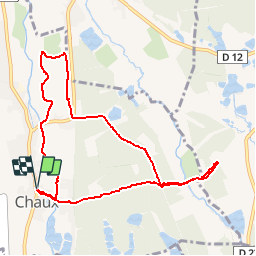
Trail Walking of 8.9 km to be discovered at Bourgogne-Franche-Comté, Territoire-de-Belfort, Chaux. This trail is proposed by bmorel@orange.fr.

Elevation profile

Positioning

Country:
France
Region :
Bourgogne-Franche-Comté
Department/Province :
Territoire-de-Belfort
Municipality :
Chaux
Location:
Unknown
Start:(UTM)
337764 ; 5285902 (32T) N.

Comments

Please log in to post a review or rate the element


Chemin encombré le long de la Savoureuse Rando peu intéressante sauf à voir de près les bassins


Trails nearby

Trail Walking Auxelles-Haut - planche belles filles par auxelle haut - Photo
Walking
benoit747

Walking

Medium
(3)
Auxelles-Haut, Bourgogne-Franche-Comté, Territoire-de-Belfort, France
14.6 km | 23 km-effort
4h 55min
Yes
Trail Walking Sermamagny - Veronne PC - Photo
Walking
Papamoju

Walking

Very easy
(2)
Sermamagny, Bourgogne-Franche-Comté, Territoire-de-Belfort, France
8.1 km | 9 km-effort
1h 59min
Yes
Trail Horseback riding Lachapelle-sous-Chaux - Lachapelle-sous-chaux / Planche des belles filles - Photo
Horseback riding
battaglia

Horseback riding

Difficult
(1)
Lachapelle-sous-Chaux, Bourgogne-Franche-Comté, Territoire-de-Belfort, France
25 km | 37 km-effort
4h 26min
Yes
Trail Mountain bike Chaux - mont jean Giro  - Photo
Mountain bike
olivier90

Mountain bike

Very easy
(1)
Chaux, Bourgogne-Franche-Comté, Territoire-de-Belfort, France
24 km | 32 km-effort
2h 4min
Yes
Trail Walking Giromagny - Le sentier des mines - Giromagny - Photo
Walking
tracegps

Walking

Medium
(1)
Giromagny, Bourgogne-Franche-Comté, Territoire-de-Belfort, France
6.4 km | 9.4 km-effort
2h 0min
Yes
Trail Walking Sermamagny - Le Malsaucy - Photo
Walking
ISATR

Walking

Very easy
Sermamagny, Bourgogne-Franche-Comté, Territoire-de-Belfort, France
9.7 km | 11.2 km-effort
2h 10min
Yes
Trail Walking Chaux - Chaux  - Photo
Walking
klopbill

Walking

Very easy
Chaux, Bourgogne-Franche-Comté, Territoire-de-Belfort, France
10 km | 13 km-effort
3h 40min
Yes
Trail Walking Sermamagny - 26 11 2019 Malcaucy  - Photo
Walking
BIDOCHONP

Walking

Very easy
Sermamagny, Bourgogne-Franche-Comté, Territoire-de-Belfort, France
10.4 km | 12 km-effort
2h 38min
Yes
Trail Electric bike Lachapelle-sous-Chaux - Andelnans-Auxelle haut - Photo
Electric bike
qlqin

Electric bike

Medium
Lachapelle-sous-Chaux, Bourgogne-Franche-Comté, Territoire-de-Belfort, France
35 km | 43 km-effort
2h 25min
No


Close
My subscriptions