


hohrod

jpblimond
User
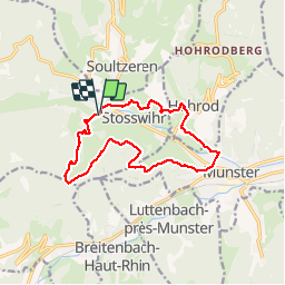

Length
12.7 km

Max alt
750 m

Uphill gradient
479 m
Km-Effort
19.1 km

Min alt
388 m

Downhill gradient
482 m
Boucle
Yes
Creation date :
2019-07-11 12:52:43.714
Updated on :
2019-07-12 07:00:03.29
3h47
Difficulty : Easy

FREE GPS app for hiking
 SityTrail
IGN / Geographical institutes
SityTrail Plus
The world is yours!
About
Trail Walking of 12.7 km to be discovered at Grand Est, Haut-Rhin, Stosswihr. This trail is proposed by jpblimond.
Positioning
Country:
France
Region :
Grand Est
Department/Province :
Haut-Rhin
Municipality :
Stosswihr
Location:
Unknown
Start:(Dec)
Start:(UTM)
358155 ; 5323903 (32U) N.
Comments