Trail Walking Passy - refuge de moede anterne  - Photo

refuge de moede anterne

 djudju39
djudju39

User

© OpenStreetMap contributors
Length
Length
19 km
Max alt
Max alt
2253 m
Uphill gradient
Uphill gradient
1209 m
Km-Effort
Km-Effort  
35 km
Min alt
Min alt
1347 m
Downhill gradient
Downhill gradient
1213 m
Boucle
Boucle
Yes
Creation date :
2014-12-10 00:00:00.0
Updated on :
2014-12-10 00:00:00.0

(0 Reviews)

Walking
Walking
7h08
Difficulty : Difficult

Scan this QR Code to open this trail in the SityTrail application

FREE GPS app for hiking

Logo SityTrail SityTrail

IGN / Geographical institutes

Download SityTrail from the App Store Download SityTrail from Google Play

Logo SityTrail SityTrail World

The world is yours!

Download SityTrail from the App Store Download SityTrail from Google Play Download SityTrail on Huawei AppGallery

About

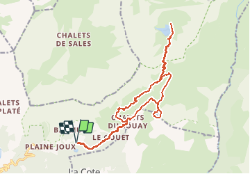
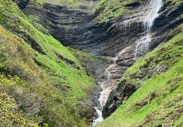
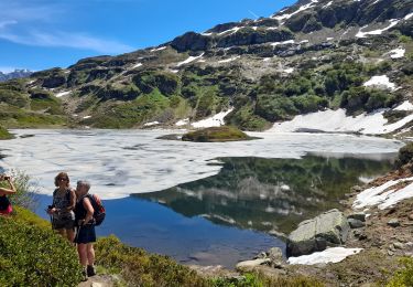
Trail Walking of 19 km to be discovered at Auvergne-Rhône-Alpes, Upper Savoy, Passy. This trail is proposed by djudju39.

Description

jour 1 : passage par le lac de pormenaz jusqu'au refuge,

jour 2 : col d'Anterne et lac d'Anterne

Elevation profile

Positioning

Country:
France
Region :
Auvergne-Rhône-Alpes
Department/Province :
Upper Savoy
Municipality :
Passy
Location:
Unknown
Start:(UTM)
325921 ; 5091236 (32T) N.

Trails nearby

Trail Walking Passy - Tour des Ayères - Passy Plaine-Joux - Photo
Walking
tracegps

Walking

Medium
(6)
Passy, Auvergne-Rhône-Alpes, Upper Savoy, France
9 km | 14.3 km-effort
2h 30min
Yes
Trail Walking Passy - Plaine Joux Barmus Ayères Lac Vert  - Photo
Walking
GUIDE
Kargil

Walking

Very easy
(1)
Passy, Auvergne-Rhône-Alpes, Upper Savoy, France
7.6 km | 12.2 km-effort
2h 18min
Yes
Trail Walking Passy - Plaine Joux-Passage du derochoir-Col de Portette-Platé - Photo
Walking
GUIDE
Kargil

Walking

Difficult
Passy, Auvergne-Rhône-Alpes, Upper Savoy, France
14.4 km | 30 km-effort
6h 42min
Yes
Trail Running Passy - grimpe de chedde ayeres - Photo
Running
winbat11

Running

Very easy
(1)
Passy, Auvergne-Rhône-Alpes, Upper Savoy, France
15 km | 28 km-effort
2h 46min
No
Trail Walking Passy - SIXT PASSY RESERVE: PLAINE JOUX- LAC DE PORMENAZ - REFUGE DE MOEDE ANTERNE - retour par la piste - Photo
Walking
djeepee74

Walking

Difficult
Passy, Auvergne-Rhône-Alpes, Upper Savoy, France
16.7 km | 28 km-effort
5h 34min
Yes
Trail Snowshoes Passy - 05-03-2022 Plaine Joux - Chalet du Souay - Photo
Snowshoes
GUIDE
Kargil

Snowshoes

Easy
Passy, Auvergne-Rhône-Alpes, Upper Savoy, France
9.2 km | 15.2 km-effort
2h 41min
Yes
Trail Walking Passy - CHAMONIX ... par les Ayères.  - Photo
Walking
GerardBouche

Walking

Medium
Passy, Auvergne-Rhône-Alpes, Upper Savoy, France
8.8 km | 14.5 km-effort
2h 48min
Yes
Trail Walking Passy - Col d anterne  - Photo
Walking
joelinou

Walking

Very difficult
Passy, Auvergne-Rhône-Alpes, Upper Savoy, France
18.6 km | 33 km-effort
6h 39min
Yes
Trail Walking Passy - SIXT PASSY RESERVE: LAC DE PORMENAZ - Photo
Walking
djeepee74

Walking

Difficult
Passy, Auvergne-Rhône-Alpes, Upper Savoy, France
13.5 km | 24 km-effort
5h 45min
No


Close
My subscriptions