Trail Mountain bike Caubeyres - Roger... c3-c2 - Photo
 Domie38
Domie38

User

© OpenStreetMap contributors
Length
Length
7.1 km
Max alt
Max alt
165 m
Uphill gradient
Uphill gradient
78 m
Km-Effort
Km-Effort  
8.1 km
Min alt
Min alt
112 m
Downhill gradient
Downhill gradient
90 m
Boucle
Boucle
No
Creation date :
2019-07-16 17:01:52.0
Updated on :
2019-07-16 18:26:23.512

(0 Reviews)

Mountain bike
Mountain bike
1h15
Difficulty : Medium

Scan this QR Code to open this trail in the SityTrail application

FREE GPS app for hiking

Logo SityTrail SityTrail

IGN / Geographical institutes

Download SityTrail from the App Store Download SityTrail from Google Play

Logo SityTrail SityTrail World

The world is yours!

Download SityTrail from the App Store Download SityTrail from Google Play Download SityTrail on Huawei AppGallery

About

Trail Mountain bike of 7.1 km to be discovered at New Aquitaine, Lot-et-Garonne, Caubeyres. This trail is proposed by Domie38.

Description

Ballade de soir en forêt à l’ombre.. chemin très roulant malgré qq passages de sable
Chevreuil et lièvre

Elevation profile

Positioning

Country:
France
Region :
New Aquitaine
Department/Province :
Lot-et-Garonne
Municipality :
Caubeyres
Location:
Unknown
Start:(UTM)
277034 ; 4902914 (31T) N.

Trails nearby

Trail On foot Xaintrailles - Xaintrailles, la balade du château - 4.7 km - Photo
On foot
PRO

On foot

Easy
Xaintrailles, New Aquitaine, Lot-et-Garonne, France
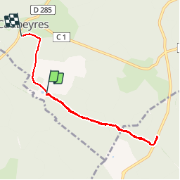
4.6 km | 5.9 km-effort
1h 19min
Yes
Trail On foot Fargues-sur-Ourbise - Fargues-sur-Ourbise, une île en forêt - 11.7 km - Photo
On foot
PRO

On foot

Easy
Fargues-sur-Ourbise, New Aquitaine, Lot-et-Garonne, France
9.9 km | 11.2 km-effort
2h 32min
No
Trail On foot Xaintrailles - Montgaillard, vers le vignoble de Gache - 9 km - Photo
On foot
PRO

On foot

Easy
Xaintrailles, New Aquitaine, Lot-et-Garonne, France
9 km | 11 km-effort
2h 30min
Yes
Trail On foot Fargues-sur-Ourbise - Fargues-sur-Ourbise - La forêt domaniale de Campet - 5.5 km - Photo
On foot
PRO

On foot

Easy
Fargues-sur-Ourbise, New Aquitaine, Lot-et-Garonne, France
5.3 km | 6 km-effort
1h 22min
Yes
Trail On foot Caubeyres - Caubeyres, la fontaine bouillonnante - 10.7 km - Photo
On foot
PRO

On foot

Easy
Caubeyres, New Aquitaine, Lot-et-Garonne, France
10.2 km | 12.8 km-effort
2h 54min
Yes
Trail On foot Damazan - Saint-Pierre-de-Buzet, la randonnée du Cap-du-Bosc - 12 km - Photo
On foot
PRO

On foot

Easy
Damazan, New Aquitaine, Lot-et-Garonne, France
14.1 km | 19 km-effort
4h 19min
Yes
Trail On foot Xaintrailles - Ambrus, la balade forestière de Pelane - 7.3 km - Photo
On foot
PRO

On foot

Easy
Xaintrailles, New Aquitaine, Lot-et-Garonne, France
7.1 km | 8.8 km-effort
1h 59min
Yes
Trail On foot Xaintrailles - Ambrus, promenade vers le vignoble de Padère - 9.5 km - Photo
On foot
PRO

On foot

Easy
Xaintrailles, New Aquitaine, Lot-et-Garonne, France
5.1 km | 6.1 km-effort
1h 23min
No
Trail On foot Xaintrailles - Ambrus, découverte de la forêt - 6.2 km - Photo
On foot
PRO

On foot

Easy
Xaintrailles, New Aquitaine, Lot-et-Garonne, France
6.2 km | 7.7 km-effort
1h 45min
Yes


Close
My subscriptions