Trail Walking Puy-Saint-Vincent - Cascades de Narreyroux - Puy Saint Vincent - Photo

Cascades de Narreyroux - Puy Saint Vincent

 tracegps
tracegps

User

© OpenStreetMap contributors
Length
Length
11.4 km
Max alt
Max alt
2053 m
Uphill gradient
Uphill gradient
588 m
Km-Effort
Km-Effort  
19.2 km
Min alt
Min alt
1458 m
Downhill gradient
Downhill gradient
588 m
Boucle
Boucle
Yes
Creation date :
2014-12-10 00:00:00.0
Updated on :
2014-12-10 00:00:00.0

(1 Reviews)

Walking
Walking
4h00
Difficulty : Difficult

Scan this QR Code to open this trail in the SityTrail application

FREE GPS app for hiking

Logo SityTrail SityTrail

IGN / Geographical institutes

Download SityTrail from the App Store Download SityTrail from Google Play

Logo SityTrail SityTrail World

The world is yours!

Download SityTrail from the App Store Download SityTrail from Google Play Download SityTrail on Huawei AppGallery

About

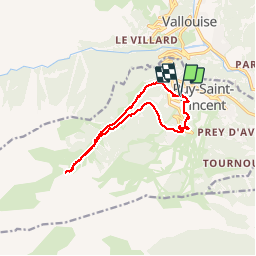
Trail Walking of 11.4 km to be discovered at Provence-Alpes-Côte d'Azur, Hautes-Alpes, Puy-Saint-Vincent. This trail is proposed by tracegps.

Description

Départ à la maison du miel, entre les stations 1400m et 1600m. On emprunte au départ le sentier des Canaux, typique du village pour accéder à la Combe de Narreyroux puis au hameau que l'on traverse jusqu'au pont qui traverse le torrent. On poursuit dans la combe pour atteindre une des cascades. Retour par le même chemin jusqu'au pont et par la station 1600.

Elevation profile

Photos

Points of interest

Point of interest Puy-Saint-Vincent - CASCADE - Photo
tracegps
PUY-SAINT-VINCENT 
Point of interest Puy-Saint-Vincent - PONT - Photo
tracegps
PUY-SAINT-VINCENT 

Positioning

Country:
France
Region :
Provence-Alpes-Côte d'Azur
Department/Province :
Hautes-Alpes
Municipality :
Puy-Saint-Vincent
Location:
Unknown
Start:(UTM)
301159 ; 4966905 (32T) N.

Comments

Please log in to post a review or rate the element


Très belle rando


Trails nearby

Trail Walking Puy-Saint-Vincent - La tête d'Oreac - Photo
Walking
Sigmut

Walking

Easy
(1)
Puy-Saint-Vincent, Provence-Alpes-Côte d'Azur, Hautes-Alpes, France
6 km | 10.4 km-effort
3h 55min
Yes
Trail On foot Vallouise-Pelvoux - Boucle vers Puy Aillaud - Photo
On foot
PRO

On foot

Easy
Vallouise-Pelvoux, Provence-Alpes-Côte d'Azur, Hautes-Alpes, France
5.3 km | 10.2 km-effort
2h 19min
No
Trail On foot Vallouise-Pelvoux - Boucle de Pelvoux - Photo
On foot
PRO

On foot

Easy
Vallouise-Pelvoux, Provence-Alpes-Côte d'Azur, Hautes-Alpes, France
12.2 km | 18.7 km-effort
4h 15min
Yes
Trail On foot Vallouise-Pelvoux - Boucle de Vallouise - Photo
On foot
PRO

On foot

Easy
Vallouise-Pelvoux, Provence-Alpes-Côte d'Azur, Hautes-Alpes, France
8.1 km | 11.6 km-effort
2h 38min
Yes
Trail Snowshoes Puy-Saint-Vincent - la tête d'Oréac - Photo
Snowshoes
GUIDE
amiral13

Snowshoes

Medium
Puy-Saint-Vincent, Provence-Alpes-Côte d'Azur, Hautes-Alpes, France
6.4 km | 11.4 km-effort
4h 7min
Yes
Trail Walking Puy-Saint-Vincent - le lac des Hermes - Photo
Walking
GUIDE
amiral13

Walking

Easy
Puy-Saint-Vincent, Provence-Alpes-Côte d'Azur, Hautes-Alpes, France
4.3 km | 6.5 km-effort
3h 9min
Yes
Trail Walking Puy-Saint-Vincent - Narreyroux au départ de PSV 1600 - Photo
Walking
GUIDE
amiral13

Walking

Very easy
Puy-Saint-Vincent, Provence-Alpes-Côte d'Azur, Hautes-Alpes, France
4.6 km | 6.3 km-effort
1h 49min
Yes
Trail Walking Puy-Saint-Vincent - Boucle col de la Pousterle et tête d'Oréac - Photo
Walking
GUIDE
amiral13

Walking

Medium
Puy-Saint-Vincent, Provence-Alpes-Côte d'Azur, Hautes-Alpes, France
9.5 km | 15.5 km-effort
3h 9min
Yes
Trail Walking Vallouise-Pelvoux - Lac de Puy Aillaud - Photo
Walking
GUIDE
R@ph

Walking

Very difficult
Vallouise-Pelvoux, Provence-Alpes-Côte d'Azur, Hautes-Alpes, France
11.5 km | 25 km-effort
5h 1min
Yes


Close
My subscriptions