Trail Walking Mont-Saint-Éloi - Autour du Mont-Saint-Éloi - Photo
 tracegps
tracegps

User

© OpenStreetMap contributors
Length
Length
14.3 km
Max alt
Max alt
156 m
Uphill gradient
Uphill gradient
179 m
Km-Effort
Km-Effort  
16.7 km
Min alt
Min alt
97 m
Downhill gradient
Downhill gradient
179 m
Boucle
Boucle
Yes
Creation date :
2014-12-10 00:00:00.0
Updated on :
2014-12-10 00:00:00.0

(3 Reviews)

Walking
Walking
3h34
Difficulty : Difficult

Scan this QR Code to open this trail in the SityTrail application

FREE GPS app for hiking

Logo SityTrail SityTrail

IGN / Geographical institutes

Download SityTrail from the App Store Download SityTrail from Google Play

Logo SityTrail SityTrail World

The world is yours!

Download SityTrail from the App Store Download SityTrail from Google Play Download SityTrail on Huawei AppGallery

About

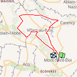
Trail Walking of 14.3 km to be discovered at Hauts-de-France, Pas-de-Calais, Mont-Saint-Éloi. This trail is proposed by tracegps.

Description

Le circuit démarre de l'office de tourisme du Mont-Saint-Éloi, au pied des ruines de l'abbaye. Celle-ci, située sur un point haut domine la campagne et offre un beau point du vue sur Arras. La première partie se fait en sous bois jusqu'à Villers-au-Bois. De l’église un petit chemin en campagne vous conduit de nouveau en sous-bois. On quitte celui-ci pour rejoindre l'ancienne vois ferrée qui longue la vallée Niclette. Au première maison de Carency, un chemin monte vers la D58. Après un gauche droite on emprunte une voie (absente des cartes IGN) qui vous amène au Sud-Est de Villers-au-bois sur le « chemin montant » en direction du point de départ.

Elevation profile

Photos

Positioning

Country:
France
Region :
Hauts-de-France
Department/Province :
Pas-de-Calais
Municipality :
Mont-Saint-Éloi
Location:
Unknown
Start:(UTM)
478118 ; 5577584 (31U) N.

Comments

Please log in to post a review or rate the element


Très bonne application impossible de se perdre surtout avec l option boussole. Bravoooooo


Bonne randonnée dans son ensemble...


Trails nearby

Trail Nordic walking Mont-Saint-Éloi - Les trois abbayes  - Photo
Nordic walking
Castor65

Nordic walking

Easy
Mont-Saint-Éloi, Hauts-de-France, Pas-de-Calais, France
16.2 km | 18.9 km-effort
3h 24min
Yes
Trail Walking Neuville-Saint-Vaast - tour Neuville p1 - Photo
Walking
Gilbert62580

Walking

Easy
Neuville-Saint-Vaast, Hauts-de-France, Pas-de-Calais, France
4 km | 4.5 km-effort
1h 1min
No
Trail Walking Souchez - Souchez-Noulette-Lorette-Ablain - Photo
Walking
tracegps

Walking

Easy
Souchez, Hauts-de-France, Pas-de-Calais, France
6.7 km | 8.4 km-effort
1h 45min
Yes
Trail Walking Neuville-Saint-Vaast - neuville saint vaast - Photo
Walking
Bernard.voyageur

Walking

Easy
(1)
Neuville-Saint-Vaast, Hauts-de-France, Pas-de-Calais, France
11.2 km | 12.4 km-effort
2h 35min
Yes
Trail Other activity Mont-Saint-Éloi - chemin des 3 abbayes - Photo
Other activity
ziane

Other activity

Very easy
Mont-Saint-Éloi, Hauts-de-France, Pas-de-Calais, France
15.7 km | 18.4 km-effort
3h 12min
Yes
Trail Walking Marœuil - Le sentier de Maroeuil entre bois et marais - Photo
Walking
tracegps

Walking

Easy
(1)
Marœuil, Hauts-de-France, Pas-de-Calais, France
7.3 km | 8.6 km-effort
1h 49min
Yes
Trail Walking Acq - Le sentier des pierres du diable - Photo
Walking
tracegps

Walking

Medium
Acq, Hauts-de-France, Pas-de-Calais, France
9.8 km | 10.8 km-effort
2h 30min
Yes
Trail Walking Mont-Saint-Éloi - Le sentier des 3 abbayes (Mont-St-Eloi)      - Photo
Walking
tracegps

Walking

Difficult
Mont-Saint-Éloi, Hauts-de-France, Pas-de-Calais, France
15.7 km | 18.4 km-effort
4h 0min
Yes
Trail Walking Neuville-Saint-Vaast -  Le sentier du souvenir (Neuville-Saint-Vaast) - Photo
Walking
tracegps

Walking

Medium
Neuville-Saint-Vaast, Hauts-de-France, Pas-de-Calais, France
13.3 km | 14.8 km-effort
3h 19min
Yes


Close
My subscriptions