Trail Walking Kall - ESt-06 - Photo
 hubbi
hubbi

User

© OpenStreetMap contributors
Length
Length
23 km
Max alt
Max alt
572 m
Uphill gradient
Uphill gradient
468 m
Km-Effort
Km-Effort  
29 km
Min alt
Min alt
428 m
Downhill gradient
Downhill gradient
507 m
Boucle
Boucle
No
Creation date :
2014-12-10 00:00:00.0
Updated on :
2014-12-10 00:00:00.0

(0 Reviews)

Walking
Walking
6h05
Difficulty : Medium

Scan this QR Code to open this trail in the SityTrail application

FREE GPS app for hiking

Logo SityTrail SityTrail

IGN / Geographical institutes

Download SityTrail from the App Store Download SityTrail from Google Play

Logo SityTrail SityTrail World

The world is yours!

Download SityTrail from the App Store Download SityTrail from Google Play Download SityTrail on Huawei AppGallery

About

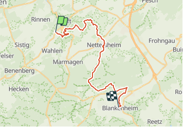
Trail Walking of 23 km to be discovered at North Rhine-Westphalia, Kreis Euskirchen, Kall. This trail is proposed by hubbi.

Description

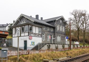
Steinfeld - Blankenheim

Elevation profile

Positioning

Country:
Germany
Region :
North Rhine-Westphalia
Department/Province :
Kreis Euskirchen
Municipality :
Kall
Location:
Unknown
Start:(UTM)
327236 ; 5597299 (32U) N.

Trails nearby

Trail On foot Kall - EifelSchleife Von Bären und Bärlauch - Photo
On foot
PRO

On foot

Medium
Kall, North Rhine-Westphalia, Kreis Euskirchen, Germany
15.7 km | 20 km-effort
4h 37min
Yes
Trail On foot Kall - EifelSchleife Zur Zeit der Römer - Photo
On foot
PRO

On foot

Easy
Kall, North Rhine-Westphalia, Kreis Euskirchen, Germany
11.5 km | 15.6 km-effort
3h 33min
Yes
Trail On foot Nettersheim - EifelSpur Kräuterpfad - Photo
On foot
PRO

On foot

Very difficult
Nettersheim, North Rhine-Westphalia, Kreis Euskirchen, Germany
41 km | 54 km-effort
12h 19min
Yes
Trail On foot Kall - EifelSchleife Kaller Sagen - Photo
On foot
PRO

On foot

Easy
Kall, North Rhine-Westphalia, Kreis Euskirchen, Germany
6.9 km | 9.4 km-effort
2h 8min
Yes
Trail On foot Kall - Kall A12 - Photo
On foot
PRO

On foot

Easy
Kall, North Rhine-Westphalia, Kreis Euskirchen, Germany
5.2 km | 7.2 km-effort
1h 37min
Yes
Trail On foot Kall - Kall 10 - Photo
On foot
PRO

On foot

Easy
Kall, North Rhine-Westphalia, Kreis Euskirchen, Germany
3.3 km | 4.7 km-effort
1h 4min
No
Trail On foot Kall - EifelSchleife Kuttenbachtal - Photo
On foot
PRO

On foot

Easy
Kall, North Rhine-Westphalia, Kreis Euskirchen, Germany
9.2 km | 13.1 km-effort
2h 58min
Yes
Trail On foot Kall - EifelSpur Pingenwanderpfad - Photo
On foot
PRO

On foot

Easy
Kall, North Rhine-Westphalia, Kreis Euskirchen, Germany
10.8 km | 14.5 km-effort
3h 17min
Yes
Trail On foot Hellenthal - Wasseramselpfad - Photo
On foot
PRO

On foot

Easy
Hellenthal, North Rhine-Westphalia, Kreis Euskirchen, Germany
5.8 km | 7.2 km-effort
1h 38min
Yes


Close
My subscriptions