


PR-Stosswihr

JMCMoreau
User
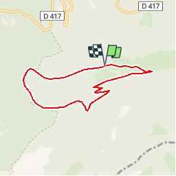

Length
6.6 km

Max alt
788 m

Uphill gradient
304 m
Km-Effort
10.6 km

Min alt
504 m

Downhill gradient
308 m
Boucle
Yes
Creation date :
2019-08-19 07:13:44.68
Updated on :
2019-08-19 07:15:46.511
3h00
Difficulty : Medium

FREE GPS app for hiking
 SityTrail
IGN / Geographical institutes
SityTrail Plus
The world is yours!
About
Trail Walking of 6.6 km to be discovered at Grand Est, Haut-Rhin, Stosswihr. This trail is proposed by JMCMoreau.
Description
Balade matinale du groupe pour le dernier jour du séjour.
Positioning
Country:
France
Region :
Grand Est
Department/Province :
Haut-Rhin
Municipality :
Stosswihr
Location:
Unknown
Start:(Dec)
Start:(UTM)
355203 ; 5324169 (32U) N.
Comments