![](/images/other/stat-length.png)
![Trail Walking Wildersbach - col de la Perheux champs du feu - Photo](https://media.geolcdn.com/t/1900/400/ext.pjpeg?maxdim=2&url=https%3A%2F%2Fmedia.geolcdn.com%2Ff%2F949b676f-6f54-45e9-b702-6744cdf0714c.jpg)
col de la Perheux champs du feu
BernardThiry
User
![Length](/images/other/stat-length.png)
Length
17.3 km
![Max alt](https://static1.geolcdn.com/siteimages/upload/files/1508320355ic_sort_altitude_max_24dp.png)
Max alt
1089 m
![Uphill gradient](https://static1.geolcdn.com/siteimages/upload/files/1508320355ic_sort_den_pos_24dp.png)
Uphill gradient
691 m
![Km-Effort](/images/other/stat-length.png)
Km-Effort
27 km
![Min alt](https://static1.geolcdn.com/siteimages/upload/files/1508320355ic_sort_altitude_min_24dp.png)
Min alt
652 m
![Downhill gradient](https://static1.geolcdn.com/siteimages/upload/files/1508320355ic_sort_den_neg_24dp.png)
Downhill gradient
691 m
![Boucle](https://static1.geolcdn.com/siteimages/upload/files/16400158638029165_repeat_loop_refresh_sync_direction_icon.png)
Boucle
Yes
Creation date :
2019-08-30 08:20:33.311
Updated on :
2019-08-30 13:47:52.656
![Walking](https://static1.geolcdn.com/sitytour/trail-icons/101.png)
4h27
Difficulty : Medium
![Scan this QR Code to open this trail in the SityTrail application](https://capi.geolives.com/qq0zvz2zws4bq2lad0pu/sitytour/trails/2186674/qr.png?size=200)
FREE GPS app for hiking
About
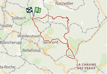
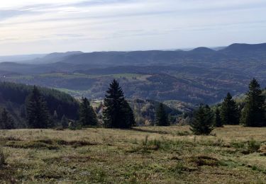
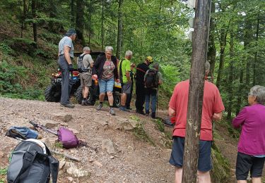
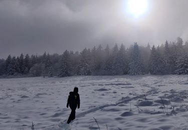
Trail Walking of 17.3 km to be discovered at Grand Est, Bas-Rhin, Wildersbach. This trail is proposed by BernardThiry.
Description
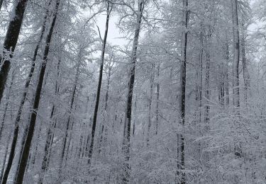
magnifique randonnée qui passe par Belmont Champ du Feu qui remonte le long des bois. Et redescend vers la cascade de la Serva retour au col
Positioning
Country:
France
Region :
Grand Est
Department/Province :
Bas-Rhin
Municipality :
Wildersbach
Location:
Unknown
Start:(Dec)
Start:(UTM)
368237 ; 5365427 (32U) N.
Comments
Trails nearby
![Trail Walking Solbach - Rando Solbach - Photo](https://media.geolcdn.com/t/375/260/ext.jpg?maxdim=2&url=https%3A%2F%2Fstatic1.geolcdn.com%2Fsiteimages%2Fupload%2Ffiles%2F1553511878bg_sport_marche.png)
![Walking Walking](https://static1.geolcdn.com/sitytour/trail-icons/101.png)
Rando Solbach
Walking
Medium
(1)
Solbach,
Grand Est,
Bas-Rhin,
France
![](/images/other/stat-length.png)
4.6 km | 6.6 km-effort
1h 29min
![](https://static1.geolcdn.com/siteimages/upload/files/16400158638029165_repeat_loop_refresh_sync_direction_icon.png)
Yes
![Trail Horseback riding Barembach - 2022-10-30 Journée Rothau Struthof Serva Perheux - Photo](https://media.geolcdn.com/t/375/260/ext.jpg?maxdim=2&url=https%3A%2F%2Fmedia.geolcdn.com%2Ff%2F12b592ba-c559-466e-bb66-3bb083a48b1a.jpg)
![Horseback riding Horseback riding](https://static1.geolcdn.com/sitytour/trail-icons/301.png)
2022-10-30 Journée Rothau Struthof Serva Perheux
Horseback riding
Difficult
Barembach,
Grand Est,
Bas-Rhin,
France
![](/images/other/stat-length.png)
25 km | 37 km-effort
5h 31min
![](https://static1.geolcdn.com/siteimages/upload/files/16400158638029165_repeat_loop_refresh_sync_direction_icon.png)
Yes
![Trail Walking Fouday - HOTEL JULIEN v - Photo](https://media.geolcdn.com/t/375/260/ext.jpg?maxdim=2&url=https%3A%2F%2Fstatic1.geolcdn.com%2Fsiteimages%2Fupload%2Ffiles%2F1553511878bg_sport_marche.png)
![Walking Walking](https://static1.geolcdn.com/sitytour/trail-icons/101.png)
HOTEL JULIEN v
Walking
Easy
(1)
Fouday,
Grand Est,
Bas-Rhin,
France
![](/images/other/stat-length.png)
7.8 km | 10.5 km-effort
2h 20min
![](https://static1.geolcdn.com/siteimages/upload/files/16400158638029165_repeat_loop_refresh_sync_direction_icon.png)
Yes
![Trail Horseback riding Belmont - Circuit VC Serva - Le Climont - Photo](https://media.geolcdn.com/t/375/260/ext.jpg?maxdim=2&url=https%3A%2F%2Fmedia.geolcdn.com%2Ff%2Fa1198139-b874-4847-adb3-efd42fb36195.jpg)
![Horseback riding Horseback riding](https://static1.geolcdn.com/sitytour/trail-icons/301.png)
Circuit VC Serva - Le Climont
Horseback riding
Medium
Belmont,
Grand Est,
Bas-Rhin,
France
![](/images/other/stat-length.png)
23 km | 33 km-effort
4h 20min
![](https://static1.geolcdn.com/siteimages/upload/files/16400158638029165_repeat_loop_refresh_sync_direction_icon.png)
No
![Trail Horseback riding Belmont - Circuit VC Le Hohwald - Serva - Photo](https://media.geolcdn.com/t/375/260/ext.jpg?maxdim=2&url=https%3A%2F%2Fmedia.geolcdn.com%2Ff%2F1588be67-92f1-44c9-a365-dcd95e3feb13.jpg)
![Horseback riding Horseback riding](https://static1.geolcdn.com/sitytour/trail-icons/301.png)
Circuit VC Le Hohwald - Serva
Horseback riding
Medium
Belmont,
Grand Est,
Bas-Rhin,
France
![](/images/other/stat-length.png)
16.2 km | 22 km-effort
2h 50min
![](https://static1.geolcdn.com/siteimages/upload/files/16400158638029165_repeat_loop_refresh_sync_direction_icon.png)
No
![Trail Walking Natzwiller - visite - Photo](https://media.geolcdn.com/t/375/260/ext.jpg?maxdim=2&url=https%3A%2F%2Fmedia.geolcdn.com%2Ff%2Ff3a361b7-b4c4-4d26-b468-ad6fc767e983.jpg)
![Walking Walking](https://static1.geolcdn.com/sitytour/trail-icons/101.png)
![Trail Walking Bellefosse - Col de la Charbonnière - château de la Roche - Bellefosse - Belmont - Photo](https://media.geolcdn.com/t/375/260/ext.jpg?maxdim=2&url=https%3A%2F%2Fmedia.geolcdn.com%2Ff%2F24310c6f-c7f0-4534-8ba0-5207981b0c8c.jpg)
![Walking Walking](https://static1.geolcdn.com/sitytour/trail-icons/101.png)
Col de la Charbonnière - château de la Roche - Bellefosse - Belmont
Walking
Very difficult
Bellefosse,
Grand Est,
Bas-Rhin,
France
![](/images/other/stat-length.png)
15.7 km | 24 km-effort
5h 27min
![](https://static1.geolcdn.com/siteimages/upload/files/16400158638029165_repeat_loop_refresh_sync_direction_icon.png)
Yes
![Trail Snowshoes Belmont - cascade de la serva - Photo](https://media.geolcdn.com/t/375/260/ext.jpg?maxdim=2&url=https%3A%2F%2Fmedia.geolcdn.com%2Ff%2F9e54cbbc-1369-400d-91a3-b8884cb0f35c.jpg)
![Snowshoes Snowshoes](https://static1.geolcdn.com/sitytour/trail-icons/504.png)
cascade de la serva
Snowshoes
Medium
Belmont,
Grand Est,
Bas-Rhin,
France
![](/images/other/stat-length.png)
7.1 km | 10.8 km-effort
3h 41min
![](https://static1.geolcdn.com/siteimages/upload/files/16400158638029165_repeat_loop_refresh_sync_direction_icon.png)
Yes
![Trail Walking Belmont - 2023-01-21 Marche Neige Belmont Champ du Feu - Photo](https://media.geolcdn.com/t/375/260/ext.jpg?maxdim=2&url=https%3A%2F%2Fmedia.geolcdn.com%2Ff%2F486c8181-dbd8-46e9-9a9c-8c70d5f67fe8.jpg)
![Walking Walking](https://static1.geolcdn.com/sitytour/trail-icons/101.png)
2023-01-21 Marche Neige Belmont Champ du Feu
Walking
Easy
Belmont,
Grand Est,
Bas-Rhin,
France
![](/images/other/stat-length.png)
12.7 km | 18.5 km-effort
4h 5min
![](https://static1.geolcdn.com/siteimages/upload/files/16400158638029165_repeat_loop_refresh_sync_direction_icon.png)
Yes