Trail Walking Lapoutroie - Tête des Faux - Photo
 pb07
pb07

User

© OpenStreetMap contributors
Length
Length
12.7 km
Max alt
Max alt
1215 m
Uphill gradient
Uphill gradient
625 m
Km-Effort
Km-Effort  
21 km
Min alt
Min alt
640 m
Downhill gradient
Downhill gradient
628 m
Boucle
Boucle
Yes
Creation date :
2019-09-05 07:03:04.325
Updated on :
2019-09-05 12:35:51.527

(1 Reviews)

Walking
Walking
4h59
Difficulty : Easy

Scan this QR Code to open this trail in the SityTrail application

FREE GPS app for hiking

Logo SityTrail SityTrail

IGN / Geographical institutes

Download SityTrail from the App Store Download SityTrail from Google Play

Logo SityTrail SityTrail World

The world is yours!

Download SityTrail from the App Store Download SityTrail from Google Play Download SityTrail on Huawei AppGallery

About

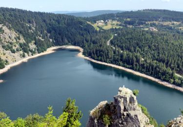
Trail Walking of 12.7 km to be discovered at Grand Est, Haut-Rhin, Lapoutroie. This trail is proposed by pb07.

Elevation profile

Positioning

Country:
France
Region :
Grand Est
Department/Province :
Haut-Rhin
Municipality :
Lapoutroie
Location:
Unknown
Start:(UTM)
362547 ; 5335797 (32U) N.

Comments

Please log in to post a review or rate the element


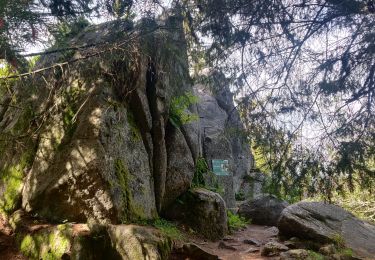
Belle promenade en sous bois mais les beaux points de vue sont assez souvent masqués par la nature . Je ne la classerais pas en facile car il y a des passages assez difficiles pour des 70 ans et davantage comme notre groupe !


Trails nearby

Trail Walking Orbey - Le Tour du Lac Blanc par le Rocher Hans et le sentier de crête - Photo
Walking
tracegps

Walking

Difficult
(3)
Orbey, Grand Est, Haut-Rhin, France
4.4 km | 7.7 km-effort
2h 30min
Yes
Trail Walking Le Bonhomme - Tête des faux . - Photo
Walking
heurtinpatrick

Walking

Medium
(1)
Le Bonhomme, Grand Est, Haut-Rhin, France
11.9 km | 16.6 km-effort
3h 46min
Yes
Trail Walking Lapoutroie - 2012-06-16 Marche aux Alisiers Orbey - Photo
Walking
GUIDE
holtzv

Walking

Easy
(2)
Lapoutroie, Grand Est, Haut-Rhin, France
11.1 km | 16.6 km-effort
2h 49min
Yes
Trail Mountain bike Orbey - Lac Blanc  - Têtes des Faux - Photo
Mountain bike
tracegps

Mountain bike

Medium
(1)
Orbey, Grand Est, Haut-Rhin, France
15.3 km | 21 km-effort
1h 0min
Yes
Trail Walking Le Bonhomme - Le Bonhomme - Circuit du village - Photo
Walking
GUIDE
Desrumaux

Walking

Easy
(1)
Le Bonhomme, Grand Est, Haut-Rhin, France
3 km | 5.3 km-effort
1h 30min
Yes
Trail Walking Orbey - 2022-07-23 Marche Lacs Blanc Noir Forlet - Photo
Walking
GUIDE
holtzv

Walking

Medium
Orbey, Grand Est, Haut-Rhin, France
16.2 km | 26 km-effort
5h 57min
Yes
Trail Walking Sainte-Marie-aux-Mines - 2021-02-14 Marche Bagenelles Brezouard Fuste de Etoile - Photo
Walking
GUIDE
holtzv

Walking

Very difficult
Sainte-Marie-aux-Mines, Grand Est, Haut-Rhin, France
17.1 km | 27 km-effort
6h 6min
Yes
Trail Walking Lapoutroie - 2020-07-19 Marche Étang du Devin Col Calvaire Tête des Faux - Photo
Walking
GUIDE
holtzv

Walking

Very easy
Lapoutroie, Grand Est, Haut-Rhin, France
14.2 km | 22 km-effort
3h 27min
Yes
Trail Walking Orbey - Orbey-Labaroche - Photo
Walking
ilur56

Walking

Easy
(1)
Orbey, Grand Est, Haut-Rhin, France
13.7 km | 21 km-effort
4h 17min
Yes


Close
My subscriptions