Trail Walking Laval-de-Cère - La maurelle laval - Photo

La maurelle laval

© OpenStreetMap contributors
Length
Length
6.8 km
Max alt
Max alt
509 m
Uphill gradient
Uphill gradient
354 m
Km-Effort
Km-Effort  
11.3 km
Min alt
Min alt
166 m
Downhill gradient
Downhill gradient
300 m
Boucle
Boucle
No
Creation date :
2014-12-10 00:00:00.0
Updated on :
2014-12-10 00:00:00.0

(0 Reviews)

Walking
Walking
1h29
Difficulty : Medium

Scan this QR Code to open this trail in the SityTrail application

FREE GPS app for hiking

Logo SityTrail SityTrail

IGN / Geographical institutes

Download SityTrail from the App Store Download SityTrail from Google Play

Logo SityTrail SityTrail World

The world is yours!

Download SityTrail from the App Store Download SityTrail from Google Play Download SityTrail on Huawei AppGallery

About

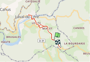
Trail Walking of 6.8 km to be discovered at Occitania, Lot, Laval-de-Cère. This trail is proposed by albert318.

Description

Aller à l' épicerie

Elevation profile

Positioning

Country:
France
Region :
Occitania
Department/Province :
Lot
Municipality :
Laval-de-Cère
Location:
Unknown
Start:(UTM)
417366 ; 4976922 (31T) N.

Trails nearby

Trail Walking Camps-Saint-Mathurin-Léobazel - Camps - Mercoeur - Photo
Walking
houbart

Walking

Difficult
(1)
Camps-Saint-Mathurin-Léobazel, New Aquitaine, Corrèze, France
14 km | 17.5 km-effort
3h 58min
Yes
Trail Walking Camps-Saint-Mathurin-Léobazel - La Via Arverna (Camps-Saint-Mathurin - Bretenoux) - Photo
Walking
tracegps

Walking

Difficult
(1)
Camps-Saint-Mathurin-Léobazel, New Aquitaine, Corrèze, France
29 km | 39 km-effort
8h 0min
No
Trail Walking Laval-de-Cère - Les cascades perdues - Photo
Walking
neleda

Walking

Easy
(1)
Laval-de-Cère, Occitania, Lot, France
13.5 km | 19.8 km-effort
5h 8min
Yes
Trail Walking Teyssieu - Teyssieu - Photo
Walking
Gaillard Isabelle

Walking

Medium
Teyssieu, Occitania, Lot, France
17.5 km | 24 km-effort
5h 30min
Yes
Trail Walking Camps-Saint-Mathurin-Léobazel - de Camps St Mathurin à Laval de Cere - Photo
Walking
neleda

Walking

Medium
Camps-Saint-Mathurin-Léobazel, New Aquitaine, Corrèze, France
20 km | 30 km-effort
6h 37min
No
Trail Mountain bike Teyssieu - SityTrail - 4x4 gorges de la cère - Photo
Mountain bike
Gpoujade

Mountain bike

Very difficult
Teyssieu, Occitania, Lot, France
37 km | 51 km-effort
3h 31min
Yes
Trail Car Saint-Laurent-les-Tours - 45 - Photo
Car
alain46

Car

Very easy
Saint-Laurent-les-Tours, Occitania, Lot, France
15.3 km | 19.7 km-effort
55min
No
Trail Horseback riding Sousceyrac-en-Quercy - comiac 19 km - Photo
Horseback riding
daniel46100

Horseback riding

Medium
Sousceyrac-en-Quercy, Occitania, Lot, France
18.9 km | 25 km-effort
3h 3min
No
Trail Walking Mercœur - la fialicie cahus la ponchie - Photo
Walking
bellouelo46

Walking

Easy
Mercœur, New Aquitaine, Corrèze, France
10.1 km | 13.9 km-effort
2h 17min
Yes


Close
My subscriptions