Trail Walking Camps-Saint-Mathurin-Léobazel - La Via Arverna (Camps-Saint-Mathurin - Bretenoux) - Photo

La Via Arverna (Camps-Saint-Mathurin - Bretenoux)

 tracegps
tracegps

User

© OpenStreetMap contributors
Length
Length
29 km
Max alt
Max alt
570 m
Uphill gradient
Uphill gradient
649 m
Km-Effort
Km-Effort  
39 km
Min alt
Min alt
135 m
Downhill gradient
Downhill gradient
1041 m
Boucle
Boucle
No
Creation date :
2014-12-10 00:00:00.0
Updated on :
2014-12-10 00:00:00.0

(1 Reviews)

Walking
Walking
8h00
Difficulty : Difficult

Scan this QR Code to open this trail in the SityTrail application

FREE GPS app for hiking

Logo SityTrail SityTrail

IGN / Geographical institutes

Download SityTrail from the App Store Download SityTrail from Google Play

Logo SityTrail SityTrail World

The world is yours!

Download SityTrail from the App Store Download SityTrail from Google Play Download SityTrail on Huawei AppGallery

About

Trail Walking of 29 km to be discovered at New Aquitaine, Corrèze, Camps-Saint-Mathurin-Léobazel. This trail is proposed by tracegps.

Description

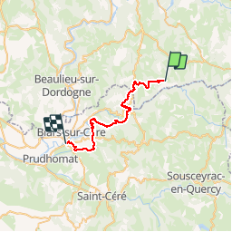
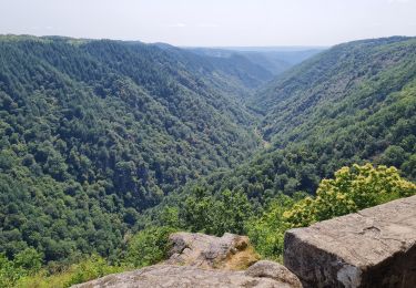
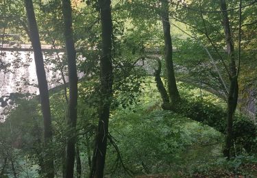
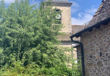
Etape 15 de la via Arverna, chemin de Saint Jacques de Compostelle entre Clermont-Ferrand et Cahors. Transition de la Corrèze vers le département du Lot permettant de découvrir de nouvelles variétés de villages et d’habitations. Passage par le sanctuaire de Belpuech et descente vers Laval de-Cère et ses anciennes maisons. Ensuite, jonction avec la GR652 en amont de la localité de La Teulière. Après avoir traversé Gangnac et Glanes, descente progressive vers le village ancien de Bretenoux par les vignobles (variante VTT). Globalement alternance de sections plates et vallonnées permettant de retrouver la Cère à de nombreuses reprises. Retrouvez l'étape n° 15 sur le site de la «Via Arverna - chemin Saint-Jacques-de-Compostelle» ainsi qu'ICI sur le site de la « Via Arverna ».

Elevation profile

Photos

Positioning

Country:
France
Region :
New Aquitaine
Department/Province :
Corrèze
Municipality :
Camps-Saint-Mathurin-Léobazel
Location:
Unknown
Start:(UTM)
420350 ; 4981571 (31T) N.

Comments

Please log in to post a review or rate the element


Pour personnes entraînées. De grands dénivelés avec des zones abruptes. Il faut une lampe de poche pour le passage (50m environ) dans un tunnel sous la voie ferrée.


Trails nearby

Trail Walking Camps-Saint-Mathurin-Léobazel - Camps - Mercoeur - Photo
Walking
houbart

Walking

Difficult
(1)
Camps-Saint-Mathurin-Léobazel, New Aquitaine, Corrèze, France
14 km | 17.5 km-effort
3h 58min
Yes
Trail Walking Laval-de-Cère - Les cascades perdues - Photo
Walking
neleda

Walking

Easy
(1)
Laval-de-Cère, Occitania, Lot, France
13.5 km | 19.8 km-effort
5h 8min
Yes
Trail Walking Camps-Saint-Mathurin-Léobazel - de Camps St Mathurin à Laval de Cere - Photo
Walking
neleda

Walking

Medium
Camps-Saint-Mathurin-Léobazel, New Aquitaine, Corrèze, France
20 km | 30 km-effort
6h 37min
No
Trail Walking Camps-Saint-Mathurin-Léobazel - Le rocher du peintre - Photo
Walking
laurentbernardbrunel

Walking

Medium
Camps-Saint-Mathurin-Léobazel, New Aquitaine, Corrèze, France
9.1 km | 11.2 km-effort
2h 2min
No
Trail Horseback riding Sousceyrac-en-Quercy - comiac 19 km - Photo
Horseback riding
daniel46100

Horseback riding

Medium
Sousceyrac-en-Quercy, Occitania, Lot, France
18.9 km | 25 km-effort
3h 3min
No
Trail Motor Mercœur - quad - Photo
Motor
alain46

Motor

Very easy
Mercœur, New Aquitaine, Corrèze, France
23 km | 28 km-effort
1h 58min
No
Trail Equestrian Camps-Saint-Mathurin-Léobazel - Lap 03 - Photo
Equestrian
melifranck

Equestrian

Easy
Camps-Saint-Mathurin-Léobazel, New Aquitaine, Corrèze, France
5.1 km | 7 km-effort
52min
Yes
Trail Running Camps-Saint-Mathurin-Léobazel - camps_25K - Photo
Running
frederic.farge

Running

Medium
Camps-Saint-Mathurin-Léobazel, New Aquitaine, Corrèze, France
25 km | 41 km-effort
Unknown
No
Trail Walking Laval-de-Cère - La maurelle laval - Photo
Walking
albert318

Walking

Medium
Laval-de-Cère, Occitania, Lot, France
6.8 km | 11.3 km-effort
1h 29min
No


Close
My subscriptions