Trail On foot Kintzheim - Vancelle- gare Haut Koenigsbourg - Photo

Vancelle- gare Haut Koenigsbourg

© OpenStreetMap contributors
Length
Length
15.2 km
Max alt
Max alt
706 m
Uphill gradient
Uphill gradient
578 m
Km-Effort
Km-Effort  
23 km
Min alt
Min alt
224 m
Downhill gradient
Downhill gradient
577 m
Boucle
Boucle
Yes
Creation date :
2019-09-19 09:56:19.901
Updated on :
2020-03-21 09:17:41.073

(0 Reviews)

On foot
On foot
5h00
Difficulty : Medium

Scan this QR Code to open this trail in the SityTrail application

FREE GPS app for hiking

Logo SityTrail SityTrail

IGN / Geographical institutes

Download SityTrail from the App Store Download SityTrail from Google Play

Logo SityTrail SityTrail World

The world is yours!

Download SityTrail from the App Store Download SityTrail from Google Play Download SityTrail on Huawei AppGallery

About

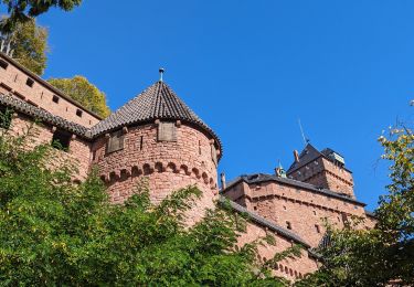
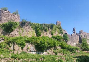
Trail On foot of 15.2 km to be discovered at Grand Est, Bas-Rhin, Kintzheim. This trail is proposed by vaillantjm.

Description

Se garer sur le parking sun la RN 59 à proximité de la maison forestière de Danielsrain à gauche en venant de Châtenois . Possibilité de pique-niquer sur les rochers au pied du château. La visite du château risque de prendre beaucoup de temps et est à réserver en dehors d'une randonnée de cette longueur.

Elevation profile

Positioning

Country:
France
Region :
Grand Est
Department/Province :
Bas-Rhin
Municipality :
Kintzheim
Location:
Unknown
Start:(UTM)
377495 ; 5348444 (32U) N.

Trails nearby

Trail Walking Châtenois - Le Hahnenberg et les balcons Sélestat - Photo
Walking
VacheKiri67

Walking

Medium
(2)
Châtenois, Grand Est, Bas-Rhin, France
12 km | 17.2 km-effort
4h 29min
Yes
Trail Walking Châtenois - Le Haut Koenigsbourg de Val de Ville - Photo
Walking
tracegps

Walking

Difficult
(1)
Châtenois, Grand Est, Bas-Rhin, France
16.8 km | 25 km-effort
5h 0min
Yes
Trail Mountain bike Thanvillé - Circuit de la Gadouille - Photo
Mountain bike
tracegps

Mountain bike

Difficult
(3)
Thanvillé, Grand Est, Bas-Rhin, France
18.4 km | 27 km-effort
1h 40min
Yes
Trail Walking Kintzheim - suuntoapp-Hiking-2023-10-15T07-53-44Z - Photo
Walking
GUIDE
holtzv

Walking

Medium
Kintzheim, Grand Est, Bas-Rhin, France
18.5 km | 28 km-effort
6h 16min
Yes
Trail Walking La Vancelle - 2020-05-21 Marche La Vancelle Boucle - Photo
Walking
GUIDE
holtzv

Walking

Very easy
La Vancelle, Grand Est, Bas-Rhin, France
16.3 km | 26 km-effort
6h 41min
Yes
Trail Walking La Vancelle - 2015-01-02 Marche Rocher du Coucou Chateau Frankenbourg - Photo
Walking
GUIDE
holtzv

Walking

Easy
(1)
La Vancelle, Grand Est, Bas-Rhin, France
10.9 km | 18.1 km-effort
3h 47min
Yes
Trail Walking Saint-Hippolyte - St hippolyte ht koenigsbourg - Photo
Walking
legereric

Walking

Medium
(2)
Saint-Hippolyte, Grand Est, Haut-Rhin, France
12 km | 18.7 km-effort
3h 27min
Yes
Trail Walking Scherwiller - chateau  de ortenbourg - Photo
Walking
dudu42

Walking

Very easy
(1)
Scherwiller, Grand Est, Bas-Rhin, France
4.6 km | 7.9 km-effort
1h 29min
Yes
Trail Walking Thannenkirch - circuit Taennchel - Photo
Walking
Patlac3

Walking

Medium
Thannenkirch, Grand Est, Haut-Rhin, France
8.6 km | 13.9 km-effort
4h 5min
Yes


Close
My subscriptions