Trail Walking Kintzheim - suuntoapp-Hiking-2023-10-15T07-53-44Z - Photo

suuntoapp-Hiking-2023-10-15T07-53-44Z

 holtzv
holtzv

User GUIDE

© OpenStreetMap contributors
Length
Length
18.5 km
Max alt
Max alt
727 m
Uphill gradient
Uphill gradient
684 m
Km-Effort
Km-Effort  
28 km
Min alt
Min alt
208 m
Downhill gradient
Downhill gradient
684 m
Boucle
Boucle
Yes
Creation date :
2023-10-15 17:04:13.469
Updated on :
2023-10-15 17:09:47.984

(0 Reviews)

Walking
Walking
6h16
Difficulty : Medium

Scan this QR Code to open this trail in the SityTrail application

FREE GPS app for hiking

Logo SityTrail SityTrail

IGN / Geographical institutes

Download SityTrail from the App Store Download SityTrail from Google Play

Logo SityTrail SityTrail World

The world is yours!

Download SityTrail from the App Store Download SityTrail from Google Play Download SityTrail on Huawei AppGallery

About

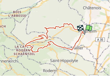
Trail Walking of 18.5 km to be discovered at Grand Est, Bas-Rhin, Kintzheim. This trail is proposed by holtzv.

Description

Boucle au départ de Kintzheim pour allez au Haut-Koenigsbourg en passant par Orschwiller, la fontaine du chevreuil, le Teufelsloch, la tombe de l'Ermite, la roche des fées, le Schaentzel, repas à l'abri Pain d'épices, la montagne des signes et la volerie des aigles.

Elevation profile

Photos

Positioning

Country:
France
Region :
Grand Est
Department/Province :
Bas-Rhin
Municipality :
Kintzheim
Location:
Unknown
Start:(UTM)
380723 ; 5345589 (32U) N.

Trails nearby

Trail Walking Châtenois - Le Hahnenberg et les balcons Sélestat - Photo
Walking
VacheKiri67

Walking

Medium
(2)
Châtenois, Grand Est, Bas-Rhin, France
12 km | 17.2 km-effort
4h 29min
Yes
Trail Walking Sélestat - Sentier de l'Illwald - Photo
Walking
tracegps

Walking

Medium
(1)
Sélestat, Grand Est, Bas-Rhin, France
13.2 km | 14.6 km-effort
3h 45min
Yes
Trail Walking Châtenois - Le Haut Koenigsbourg de Val de Ville - Photo
Walking
tracegps

Walking

Difficult
(1)
Châtenois, Grand Est, Bas-Rhin, France
16.8 km | 25 km-effort
5h 0min
Yes
Trail Walking Saint-Hippolyte - St hippolyte ht koenigsbourg - Photo
Walking
legereric

Walking

Medium
(2)
Saint-Hippolyte, Grand Est, Haut-Rhin, France
12 km | 18.7 km-effort
3h 27min
Yes
Trail Walking Scherwiller - chateau  de ortenbourg - Photo
Walking
dudu42

Walking

Very easy
(1)
Scherwiller, Grand Est, Bas-Rhin, France
4.6 km | 7.9 km-effort
1h 29min
Yes
Trail Walking Saint-Hippolyte - St-Hippolyte - Rorschwihr - Grasberg - Bergheim - Reichenberg - Rodern - Photo
Walking
VacheKiri67

Walking

Medium
Saint-Hippolyte, Grand Est, Haut-Rhin, France
17.3 km | 22 km-effort
4h 28min
Yes
Trail Walking Sélestat - Sélestat : balade dans le Ried - Photo
Walking
Bart2015

Walking

Difficult
Sélestat, Grand Est, Bas-Rhin, France
11.4 km | 12.6 km-effort
2h 51min
Yes
Trail Electric bike Sélestat - Vignoble  - Photo
Electric bike
apa

Electric bike

Very easy
Sélestat, Grand Est, Bas-Rhin, France
50 km | 57 km-effort
3h 4min
No
Trail Walking Rorschwihr - rorschwihr ac3 - Photo
Walking
colsonandre

Walking

Medium
Rorschwihr, Grand Est, Haut-Rhin, France
6.8 km | 9.2 km-effort
3h 54min
Yes


Close
My subscriptions