Trail Walking Chamant - Le Chêne à l'Image _ 6,8 km - Photo

Le Chêne à l'Image _ 6,8 km

© OpenStreetMap contributors
Length
Length
6.8 km
Max alt
Max alt
182 m
Uphill gradient
Uphill gradient
115 m
Km-Effort
Km-Effort  
8.3 km
Min alt
Min alt
113 m
Downhill gradient
Downhill gradient
115 m
Boucle
Boucle
Yes
Creation date :
2014-12-10 00:00:00.0
Updated on :
2014-12-10 00:00:00.0

(0 Reviews)

Walking
Walking
1h48
Difficulty : Easy

Scan this QR Code to open this trail in the SityTrail application

FREE GPS app for hiking

Logo SityTrail SityTrail

IGN / Geographical institutes

Download SityTrail from the App Store Download SityTrail from Google Play

Logo SityTrail SityTrail World

The world is yours!

Download SityTrail from the App Store Download SityTrail from Google Play Download SityTrail on Huawei AppGallery

About

Trail Walking of 6.8 km to be discovered at Hauts-de-France, Oise, Chamant. This trail is proposed by Pousscailleux.

Description

Départ du parking du Poteau des Blancs Sablons.
Le Chêne à l'Image est un arbre vénéré sur lequel, en haut du tronc, a été installée une reproduction de la Vierge Marie.

Elevation profile

Points of interest

Point of interest Fleurines - Chêne à l'Image - Photo
Pousscailleux
Point of interest Fleurines - Croix Saint Rieul - Photo
Pousscailleux

Positioning

Country:
France
Region :
Hauts-de-France
Department/Province :
Oise
Municipality :
Chamant
Location:
Unknown
Start:(UTM)
471773 ; 5454834 (31U) N.

Trails nearby

Trail Walking Villers-Saint-Frambourg-Ognon - MR_OGNON (par BALAGNY-sur-AUNETTE)_5.4Km - Photo
Walking

Walking

Medium
(3)
Villers-Saint-Frambourg-Ognon, Hauts-de-France, Oise, France
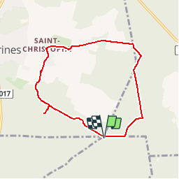
5.4 km | 6.4 km-effort
1h 27min
Yes
Trail On foot Senlis - SENLIS CITE ROYALE(FFK) - Photo
On foot
GR77LP

On foot

Very easy
(1)
Senlis, Hauts-de-France, Oise, France
4.6 km | 5.2 km-effort
2h 0min
Yes
Trail Walking Fleurines - Fleurines Grand parcours - Photo
Walking
CC.RIDER

Walking

Easy
(1)
Fleurines, Hauts-de-France, Oise, France
20 km | 24 km-effort
5h 8min
Yes
Trail Walking Chamant - Chamant Supermini-rando - Photo
Walking
CC.RIDER

Walking

Easy
(8)
Chamant, Hauts-de-France, Oise, France
8 km | 9.3 km-effort
2h 7min
Yes
Trail Walking Pontpoint - Mont Pagnotte Grand parcours - Photo
Walking
CC.RIDER

Walking

Medium
(2)
Pontpoint, Hauts-de-France, Oise, France
16.6 km | 22 km-effort
4h 36min
Yes
Trail Hybrid bike Fleurines - randonnée Au5v OT Ccpoh halatte - Photo
Hybrid bike
gilbertdu60

Hybrid bike

Easy
Fleurines, Hauts-de-France, Oise, France
30 km | 35 km-effort
Unknown
Yes
Trail On foot Senlis - De Orrouy à Coye - Photo
On foot
PRO

On foot

Easy
Senlis, Hauts-de-France, Oise, France
10.1 km | 11.2 km-effort
2h 33min
No
Trail On foot Aumont-en-Halatte - Chemin Royal - Photo
On foot
PRO

On foot

Easy
Aumont-en-Halatte, Hauts-de-France, Oise, France
3.5 km | 4 km-effort
54min
No
Trail Walking Villers-Saint-Frambourg-Ognon - SM_OGNON-(ex BALAGNY-sur-AUNETTE)_8.3Km - Photo
Walking
GR77LP

Walking

Medium
(4)
Villers-Saint-Frambourg-Ognon, Hauts-de-France, Oise, France
8.3 km | 9.6 km-effort
2h 10min
Yes


Close
My subscriptions