Trail On foot Saint-Égrève - le tour du NERON - Photo
 elibon
elibon

User

© OpenStreetMap contributors
Length
Length
13.4 km
Max alt
Max alt
636 m
Uphill gradient
Uphill gradient
588 m
Km-Effort
Km-Effort  
21 km
Min alt
Min alt
212 m
Downhill gradient
Downhill gradient
603 m
Boucle
Boucle
No
Creation date :
2019-11-08 09:25:00.803
Updated on :
2019-11-08 09:34:43.529

(0 Reviews)

On foot
On foot
--
Difficulty : Medium

Scan this QR Code to open this trail in the SityTrail application

FREE GPS app for hiking

Logo SityTrail SityTrail

IGN / Geographical institutes

Download SityTrail from the App Store Download SityTrail from Google Play

Logo SityTrail SityTrail World

The world is yours!

Download SityTrail from the App Store Download SityTrail from Google Play Download SityTrail on Huawei AppGallery

About

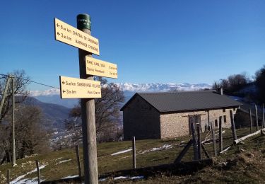
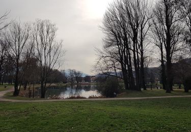
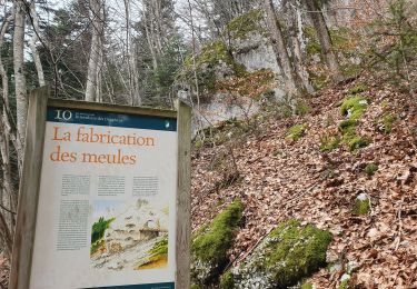
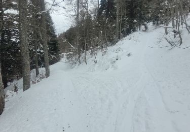
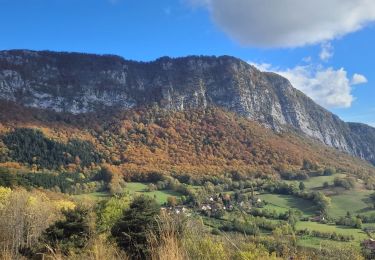
Trail On foot of 13.4 km to be discovered at Auvergne-Rhône-Alpes, Isère, Saint-Égrève. This trail is proposed by elibon.

Description

Randonnée aux départs et a l'arrivée des transports en communs  RAM de la TAG
La Monta -Proveysieux - Quaix en Chartreuse - Clémenciéres- Narbonne - Pique- Pierre (St. Martin le Vinoux

Elevation profile

Positioning

Country:
France
Region :
Auvergne-Rhône-Alpes
Department/Province :
Isère
Municipality :
Saint-Égrève
Location:
Unknown
Start:(UTM)
710634 ; 5013139 (31T) N.

Comments

Please log in to post a review or rate the element


Trails nearby

Trail Walking Sassenage - La ferme Durand - Photo
Walking
crocau

Walking

Easy
(1)
Sassenage, Auvergne-Rhône-Alpes, Isère, France
6.2 km | 13.3 km-effort
2h 7min
Yes
Trail Nordic walking Sassenage - Parc de l'Ovalie - Noyarey - Photo
Nordic walking
patjobou

Nordic walking

Easy
(1)
Sassenage, Auvergne-Rhône-Alpes, Isère, France
11.8 km | 13 km-effort
2h 20min
No
Trail Walking Proveysieux - le rocher de l'Eglise en traversee - Photo
Walking
cmarit

Walking

Difficult
(1)
Proveysieux, Auvergne-Rhône-Alpes, Isère, France
10.5 km | 22 km-effort
8h 16min
Yes
Trail Mountain bike La Tronche - bastille vtt - Photo
Mountain bike
virtumanu

Mountain bike

Medium
(1)
La Tronche, Auvergne-Rhône-Alpes, Isère, France
11.1 km | 19.6 km-effort
24min
Yes
Trail Walking Mont-Saint-Martin - la Meulière des Dauphins par Mont St Martin - Photo
Walking
Ak38

Walking

Medium
Mont-Saint-Martin, Auvergne-Rhône-Alpes, Isère, France
6.3 km | 11.1 km-effort
1h 52min
Yes
Trail Touring skiing Proveysieux - 140124 Mont Fromage - Photo
Touring skiing
mzonzon05

Touring skiing

Easy
Proveysieux, Auvergne-Rhône-Alpes, Isère, France
8.5 km | 18 km-effort
3h 21min
Yes
Trail Walking Mont-Saint-Martin - 111123 - Photo
Walking
mzonzon05

Walking

Medium
Mont-Saint-Martin, Auvergne-Rhône-Alpes, Isère, France
4.2 km | 9.3 km-effort
1h 54min
Yes
Trail Walking Fontaine - le tour du brisou par la baraque du veymont  - Photo
Walking
Youcef Atallah

Walking

Very difficult
Fontaine, Auvergne-Rhône-Alpes, Isère, France
125 km | 190 km-effort
8h 23min
Yes
Trail Walking Saint-Égrève - 290423 Tour du Néron - Photo
Walking
mzonzon05

Walking

Very difficult
Saint-Égrève, Auvergne-Rhône-Alpes, Isère, France
12.3 km | 21 km-effort
4h 22min
No


Close
My subscriptions