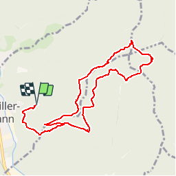
Bitschwiller les Thann - Rehbrunnel - Abri du Becherkopf - Roche Albert

patrickbeyrath
User

Length
10.3 km

Max alt
873 m

Uphill gradient
460 m
Km-Effort
16.4 km

Min alt
421 m

Downhill gradient
460 m
Boucle
Yes
Creation date :
2019-11-15 07:49:29.511
Updated on :
2019-11-15 07:58:36.242
--
Difficulty : Medium

FREE GPS app for hiking
 SityTrail
IGN / Geographical institutes
SityTrail Plus
The world is yours!
About
Trail On foot of 10.3 km to be discovered at Grand Est, Haut-Rhin, Bitschwiller-lès-Thann. This trail is proposed by patrickbeyrath.
Description
Pour le départ, se garer au bout de la rue des Vignes à Bitschwiller les Thann - Col de Grumbach - Rehbrunnel - Abri du Becherkopf - Enzenbachkopf - Roche Albert et retour
Positioning
Country:
France
Region :
Grand Est
Department/Province :
Haut-Rhin
Municipality :
Bitschwiller-lès-Thann
Location:
Unknown
Start:(Dec)
Start:(UTM)
357118 ; 5299231 (32T) N.
Comments