Trail Walking Ubaye-Serre-Ponçon - 20191203_Espinasse L'escoubaye - Photo
© OpenStreetMap contributors
Length
Length
16.3 km
Max alt
Max alt
1005 m
Uphill gradient
Uphill gradient
572 m
Km-Effort
Km-Effort  
24 km
Min alt
Min alt
658 m
Downhill gradient
Downhill gradient
572 m
Boucle
Boucle
Yes
Creation date :
2019-12-03 08:12:48.17
Updated on :
2019-12-13 14:21:14.544

(0 Reviews)

Walking
Walking
5h50
Difficulty : Medium

Scan this QR Code to open this trail in the SityTrail application

FREE GPS app for hiking

Logo SityTrail SityTrail

IGN / Geographical institutes

Download SityTrail from the App Store Download SityTrail from Google Play

Logo SityTrail SityTrail World

The world is yours!

Download SityTrail from the App Store Download SityTrail from Google Play Download SityTrail on Huawei AppGallery

About

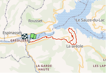
Trail Walking of 16.3 km to be discovered at Provence-Alpes-Côte d'Azur, Alpes-de-Haute-Provence, Ubaye-Serre-Ponçon. This trail is proposed by PapouBertrand.

Description

Randonnée Marche de 16 km et 570 mètres de dénivelé, un peu longue mais facile à découvrir au départ d'Espinasse via La Bréole, ALPES-DE-HAUTE-PROVENCE, PROVENCE-ALPES-COTE D'AZUR.
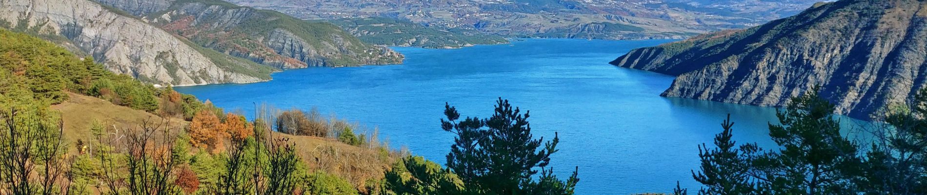
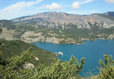
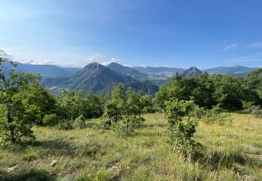
De magnifiques vues sur la boucle de l'Escoubaye.
Possibilité de se ravitailler à la fromagerie de La Bréole.

Elevation profile

Photos

Positioning

Country:
France
Region :
Provence-Alpes-Côte d'Azur
Department/Province :
Alpes-de-Haute-Provence
Municipality :
Ubaye-Serre-Ponçon
Location:
La Bréole
Start:(UTM)
280559 ; 4926542 (32T) N.

Trails nearby

Trail Walking Théus - R47   Les Demoiselles Coiffees - Photo
Walking
GUIDE+

Walking

Very easy
(2)
Théus, Provence-Alpes-Côte d'Azur, Hautes-Alpes, France
6.7 km | 13.4 km-effort
2h 31min
Yes
Trail Walking Ubaye-Serre-Ponçon - le clôt de la cime. - Photo
Walking
GILOU440

Walking

Easy
(1)
Ubaye-Serre-Ponçon, Provence-Alpes-Côte d'Azur, Alpes-de-Haute-Provence, France
12.5 km | 19.8 km-effort
4h 0min
Yes
Trail Walking Ubaye-Serre-Ponçon - Circuit de l'Escoubaye 25 -12- 2014 - Photo
Walking
Dervalmarc

Walking

Easy
(1)
Ubaye-Serre-Ponçon, Provence-Alpes-Côte d'Azur, Alpes-de-Haute-Provence, France
6.9 km | 10.1 km-effort
2h 32min
Yes
Trail Walking Ubaye-Serre-Ponçon - L'Escoubaye - Photo
Walking
FERAUD

Walking

Medium
(1)
Ubaye-Serre-Ponçon, Provence-Alpes-Côte d'Azur, Alpes-de-Haute-Provence, France
6 km | 9 km-effort
1h 22min
Yes
Trail Walking Ubaye-Serre-Ponçon - L'Escoubaye - Photo
Walking
saintherant

Walking

Easy
(1)
Ubaye-Serre-Ponçon, Provence-Alpes-Côte d'Azur, Alpes-de-Haute-Provence, France
4.5 km | 7.4 km-effort
2h 0min
Yes
Trail Walking Ubaye-Serre-Ponçon - Circuit de Costebelle - Photo
Walking
saintherant

Walking

Medium
(2)
Ubaye-Serre-Ponçon, Provence-Alpes-Côte d'Azur, Alpes-de-Haute-Provence, France
8.2 km | 12.8 km-effort
2h 30min
Yes
Trail Walking Théus - J1 2023 - Theus le Mont Colombis - Photo
Walking
ETMU5496

Walking

Difficult
(1)
Théus, Provence-Alpes-Côte d'Azur, Hautes-Alpes, France
13 km | 25 km-effort
3h 42min
Yes
Trail Walking Rousset - La Viste  - Photo
Walking
GUIDE
David25400

Walking

Medium
Rousset, Provence-Alpes-Côte d'Azur, Hautes-Alpes, France
5.6 km | 10.4 km-effort
1h 50min
Yes
Trail Walking Rousset - 20200929_La Viste par Clos Morel - Photo
Walking
PapouBertrand

Walking

Medium
Rousset, Provence-Alpes-Côte d'Azur, Hautes-Alpes, France
13.7 km | 23 km-effort
5h 46min
Yes


Close
My subscriptions