


le Honeck

viam19
User
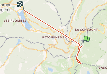

Length
9.6 km

Max alt
1352 m

Uphill gradient
524 m
Km-Effort
18.1 km

Min alt
792 m

Downhill gradient
950 m
Boucle
No
Creation date :
2019-12-26 13:52:10.866
Updated on :
2019-12-26 15:28:15.569
1h08
Difficulty : Medium

FREE GPS app for hiking
 SityTrail
IGN / Geographical institutes
SityTrail Plus
The world is yours!
About
Trail Walking of 9.6 km to be discovered at Grand Est, Haut-Rhin, Stosswihr. This trail is proposed by viam19.
Description
aller retour
Photos

Positioning
Country:
France
Region :
Grand Est
Department/Province :
Haut-Rhin
Municipality :
Stosswihr
Location:
Unknown
Start:(Dec)
Start:(UTM)
352313 ; 5323942 (32U) N.
Comments