Trail Walking Vallorbe - Dent de Vaulion - Photo
 vallorbe
vallorbe

User

© OpenStreetMap contributors
Length
Length
16.3 km
Max alt
Max alt
1470 m
Uphill gradient
Uphill gradient
843 m
Km-Effort
Km-Effort  
28 km
Min alt
Min alt
746 m
Downhill gradient
Downhill gradient
836 m
Boucle
Boucle
No
Creation date :
2014-12-11 00:00:00.0
Updated on :
2014-12-11 00:00:00.0

(2 Reviews)

Walking
Walking
5h00
Difficulty : Unknown

Scan this QR Code to open this trail in the SityTrail application

FREE GPS app for hiking

Logo SityTrail SityTrail

IGN / Geographical institutes

Download SityTrail from the App Store Download SityTrail from Google Play

Logo SityTrail SityTrail World

The world is yours!

Download SityTrail from the App Store Download SityTrail from Google Play Download SityTrail on Huawei AppGallery

About

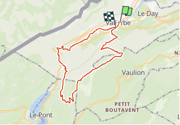
Trail Walking of 16.3 km to be discovered at Vaud, District du Jura-Nord vaudois, Vallorbe. This trail is proposed by vallorbe.

Description

Von Vallorbe steigt ein Weg über die "Grands Crêts" (einstige Kalköfen) bis unterhalb der Waldhütte Béboux hinauf, dann führt ein Waldweg nach "Sur Voué".
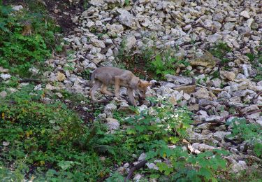
Nachdem Sie die Blumenwiesen durchquert haben, gehen Sie auf dem Kamm entlang, wo Sie vielleicht Gämsen sehen.
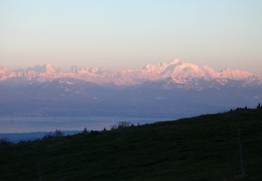
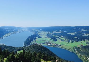
Auf dem Gipfel der Dent de Vaulion (1482 m) wird die zweieinhalbstündige Anstrengung mit einem wunderschönen Panorama belohnt: 6 Seen, die Berner, Walliser und Savoyer Alpen, deren Gipfel Sie mit Hilfe einer Orientierungstafel benennen können.

Nach einer Stärkung im Chalet-Restaurant nehmen Sie den Abstieg über Weiden Richtung Le Pont in Angriff; rechts über einen steilen Waldweg gelangen Sie auf die alte Strasse nach Vallorbe.
Folgen Sie der Markierung "voie 5" auf einem von Gebüsch gesäumten Weg bis zu den Combes de Seignegerêt, steigen Sie durch die Pouette Combe zur Strasse hinab, die zu den Tropfsteinhöhlen (Grottes) führt.
Rückweg nach Vallorbe am rechten Ufer der Orbe.

Karte: "3 Vallons" 1:25''000
Höhendifferenz: 700 Meter

Elevation profile

Points of interest

Point of interest Vallorbe - Départ depuis la Poste - Photo
vallorbe
Point of interest Vaulion - Dent de Vaulion - Photo
vallorbe
Point of interest Vaulion - Chalet de la Dent - Photo
vallorbe
Point of interest L'Abbaye - Cabane de la Dent  - Photo
vallorbe
Point of interest Vallorbe - Grottes de Vallorbe - Photo
vallorbe
Point of interest Vallorbe - Juraparc - Photo
vallorbe
VALLORBE 

Positioning

Country:
Switzerland
Region :
Vaud
Department/Province :
District du Jura-Nord vaudois
Municipality :
Vallorbe
Location:
Unknown
Start:(UTM)
299770 ; 5176537 (32T) N.

Comments

Please log in to post a review or rate the element


Très belle randonnée avec panorama magnifique a la dent de vollion fin de la ballade (passage par jura parc, et petit tronçon de quelques mettre sur une départementale en virage) moins agréable. Il faudrait voir à prendre la bifurcation directe vers Vallorbe. Cependant je ne sais pas si cette bifurcation fait passer par la grotte au fées, qui est à voir! Je conseille à l'entrée de Vallorbe de longer par la rive droite, plus agréable!


Très belle randonnée avec panorama magnifique a la dent de vollion fin de la ballade (passage par jura parc, et petit tronçon de quelques mettre sur une départementale en virage) moins agréable. Il faudrait voir à prendre la bifurcation directe vers Vallorbe. Cependant je ne sais pas si cette bifurcation fait passer par la grotte au fées, qui est à voir! Je conseille à l'entrée de Vallorbe de longer par la rive droite, plus agréable!


Trails nearby

Trail Mountain bike Vallorbe - Le Suchet - Photo
Mountain bike
GUIDE+

Mountain bike

Very easy
(1)
Vallorbe, Vaud, District du Jura-Nord vaudois, Switzerland
35 km | 53 km-effort
14h 41min
Yes
Trail On foot Vallorbe - Mont d'Orzeires - Le Pont Gare - Photo
On foot
PRO

On foot

Easy
Vallorbe, Vaud, District du Jura-Nord vaudois, Switzerland
3.2 km | 4.4 km-effort
59min
No
Trail On foot Ballaigues - Ballaigues-Vallorbe - Photo
On foot
PRO

On foot

Easy
Ballaigues, Vaud, District du Jura-Nord vaudois, Switzerland
5.1 km | 6.3 km-effort
1h 25min
No
Trail On foot Vallorbe - Saigne Geret-Les Revines - Photo
On foot
PRO

On foot

Easy
Vallorbe, Vaud, District du Jura-Nord vaudois, Switzerland
3.5 km | 4.1 km-effort
56min
No
Trail On foot Juriens - TP Mollendruz - Romainmôtie - Photo
On foot
PRO

On foot

Easy
Juriens, Vaud, District du Jura-Nord vaudois, Switzerland
7.8 km | 11.6 km-effort
2h 38min
No
Trail Walking L'Abbaye - La Dent de Vaulion - Photo
Walking
drarep

Walking

Very difficult
(1)
L'Abbaye, Vaud, District du Jura-Nord vaudois, Switzerland
14.6 km | 22 km-effort
4h 31min
Yes
Trail Walking Rochejean - Mont d'or  - Photo
Walking
eltonnermou

Walking

Easy
Rochejean, Bourgogne-Franche-Comté, Doubs, France
11.9 km | 17.5 km-effort
4h 53min
Yes
Trail Walking Jougne - La Jougnena - Photo
Walking
daniellebou

Walking

Very difficult
(1)
Jougne, Bourgogne-Franche-Comté, Doubs, France
17.7 km | 24 km-effort
5h 32min
Yes
Trail Snowshoes Longevilles-Mont-d'Or - Les Longevilles Mont D'Or CAF - Photo
Snowshoes
TRIMAILLE

Snowshoes

Medium
(1)
Longevilles-Mont-d'Or, Bourgogne-Franche-Comté, Doubs, France
8.4 km | 13 km-effort
8h 27min
Yes


Close
My subscriptions