Trail Walking Meymac - Lestrade-La Vialle-Le Colomby - Photo

Lestrade-La Vialle-Le Colomby

 viam19
viam19

User

© OpenStreetMap contributors
Length
Length
13.2 km
Max alt
Max alt
901 m
Uphill gradient
Uphill gradient
387 m
Km-Effort
Km-Effort  
18.3 km
Min alt
Min alt
727 m
Downhill gradient
Downhill gradient
387 m
Boucle
Boucle
Yes
Creation date :
2020-01-05 08:16:07.277
Updated on :
2020-01-05 16:30:33.721

(0 Reviews)

Walking
Walking
5h08
Difficulty : Easy

Scan this QR Code to open this trail in the SityTrail application

FREE GPS app for hiking

Logo SityTrail SityTrail

IGN / Geographical institutes

Download SityTrail from the App Store Download SityTrail from Google Play

Logo SityTrail SityTrail World

The world is yours!

Download SityTrail from the App Store Download SityTrail from Google Play Download SityTrail on Huawei AppGallery

About

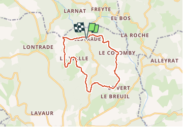
Trail Walking of 13.2 km to be discovered at New Aquitaine, Corrèze, Meymac. This trail is proposed by viam19.

Description

Randonnée en boucle exclusivement sur chemins, pistes et petites routes.
En cet hiver 2019/2020, pistes défoncées par les engins des forestiers principalement sur la 1ère moitié de la randonnée.

Elevation profile

Photos

Positioning

Country:
France
Region :
New Aquitaine
Department/Province :
Corrèze
Municipality :
Meymac
Location:
Unknown
Start:(UTM)
434622 ; 5048443 (31T) N.

Trails nearby

Trail Walking Saint-Germain-Lavolps - Fred st Germain lavolps - Photo
Walking
arnoultjf

Walking

Difficult
Saint-Germain-Lavolps, New Aquitaine, Corrèze, France
9.4 km | 12.7 km-effort
3h 35min
Yes
Trail Walking Meymac - Tour du Mont Bessou. - Photo
Walking
Indi34

Walking

Easy
Meymac, New Aquitaine, Corrèze, France
3.4 km | 4.9 km-effort
1h 0min
No
Trail Walking Meymac - Montagne du Cloup, les Farges - Photo
Walking
viam19

Walking

Medium
Meymac, New Aquitaine, Corrèze, France
13.8 km | 19.1 km-effort
4h 36min
Yes
Trail Walking Meymac - Puy Baubière - Photo
Walking
famille.scharf

Walking

Medium
Meymac, New Aquitaine, Corrèze, France
6.3 km | 9.2 km-effort
2h 15min
Yes
Trail Walking Alleyrat - Alleyrat Corrèze  - Photo
Walking
zoe.vienne

Walking

Medium
Alleyrat, New Aquitaine, Corrèze, France
22 km | 29 km-effort
5h 0min
Yes
Trail Mountain bike Meymac - Le toit du Limousin 16 km - Meymac - Pays de Haute Corrèze  - Photo
Mountain bike
tracegps

Mountain bike

Difficult
(1)
Meymac, New Aquitaine, Corrèze, France
16.4 km | 23 km-effort
1h 30min
Yes
Trail Walking Meymac - Le toit du Limousin 16 km - Meymac - Pays de Haute Corrèze  - Photo
Walking
tracegps

Walking

Difficult
(1)
Meymac, New Aquitaine, Corrèze, France
16.4 km | 23 km-effort
4h 0min
Yes
Trail Mountain bike Meymac - Le toit du Limousin 19 km - Meymac - Pays de Haute Corrèze  - Photo
Mountain bike
tracegps

Mountain bike

Difficult
Meymac, New Aquitaine, Corrèze, France
19 km | 26 km-effort
1h 45min
Yes
Trail Walking Meymac - Le toit du Limousin 19 km - Meymac - Pays de Haute Corrèze  - Photo
Walking
tracegps

Walking

Difficult
(2)
Meymac, New Aquitaine, Corrèze, France
19 km | 26 km-effort
4h 30min
Yes


Close
My subscriptions