Trail Walking Masevaux-Niederbruck - Buchberg - Photo
 helmut68
helmut68

User

© OpenStreetMap contributors
Length
Length
8.5 km
Max alt
Max alt
765 m
Uphill gradient
Uphill gradient
393 m
Km-Effort
Km-Effort  
13.7 km
Min alt
Min alt
399 m
Downhill gradient
Downhill gradient
395 m
Boucle
Boucle
Yes
Creation date :
2020-01-05 11:04:25.903
Updated on :
2020-01-05 16:45:57.151

(0 Reviews)

Walking
Walking
2h36
Difficulty : Easy

Scan this QR Code to open this trail in the SityTrail application

FREE GPS app for hiking

Logo SityTrail SityTrail

IGN / Geographical institutes

Download SityTrail from the App Store Download SityTrail from Google Play

Logo SityTrail SityTrail World

The world is yours!

Download SityTrail from the App Store Download SityTrail from Google Play Download SityTrail on Huawei AppGallery

About

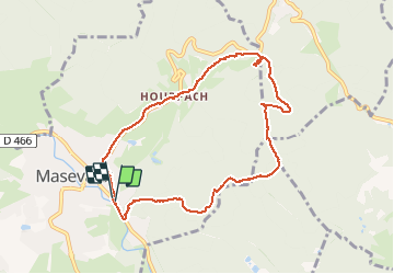
Trail Walking of 8.5 km to be discovered at Grand Est, Haut-Rhin, Masevaux-Niederbruck. This trail is proposed by helmut68.

Description

Départ à la caserne des pompiers de Masevaux , suivre le marquage "triangle jaune" jusqu'au Buchberg ,ensuite le " triangle rouge" jusqu'au Schirm, puis le rectangle " rouge blanc rouge " jusqu'au retour à Masevaux.
Belle petite balade ou l'on peut prendre le  repas tiré du sac sur un banc au Buchberg , sinon un peu plus loin au Rocher du Poilus ( plusieurs tables  ) ou au col du Schirm ( plusieurs tables) .
Alors à vos chaussures.....

Elevation profile

Photos

Positioning

Country:
France
Region :
Grand Est
Department/Province :
Haut-Rhin
Municipality :
Masevaux-Niederbruck
Location:
Masevaux
Start:(UTM)
350343 ; 5292930 (32T) N.

Trails nearby

Trail Walking Masevaux-Niederbruck - Masevaux - Rossberg par le belvédère du Fuchsfelsen - Photo
Walking
Bart2015

Walking

Medium
(1)
Masevaux-Niederbruck, Grand Est, Haut-Rhin, France
19.9 km | 34 km-effort
4h 44min
Yes
Trail Walking Sentheim - Sentheim Rossberg - Photo
Walking
helmut68

Walking

Medium
(1)
Sentheim, Grand Est, Haut-Rhin, France
27 km | 40 km-effort
6h 11min
Yes
Trail Walking Bourbach-le-Haut - 2024-01-12_14h17m14_239006910 - Photo
Walking
GUIDE
mumu.larandonneuse

Walking

Difficult
Bourbach-le-Haut, Grand Est, Haut-Rhin, France
11.4 km | 18.5 km-effort
4h 12min
Yes
Trail Walking Lauw - 2022-07-14 Marche Lauw Refuge CAF Baerenkopf - Photo
Walking
GUIDE
holtzv

Walking

Very difficult
Lauw, Grand Est, Haut-Rhin, France
18.4 km | 31 km-effort
5h 35min
No
Trail On foot Sentheim - Sentier géologique du Wolfloch - Photo
On foot
PRO

On foot

Easy
Sentheim, Grand Est, Haut-Rhin, France
3.8 km | 4.8 km-effort
1h 5min
No
Trail On foot Sentheim - Sentheim - Bergwald - Eichwald - Guevenheim - Sentheim - Photo
On foot
patrickbeyrath

On foot

Easy
(1)
Sentheim, Grand Est, Haut-Rhin, France
13.4 km | 16.6 km-effort
Unknown
Yes
Trail Walking Bitschwiller-lès-Thann - 68 Col du Hundsrück  - FA Gsang - retour ThannerHubel - Photo
Walking

Walking

Medium
(1)
Bitschwiller-lès-Thann, Grand Est, Haut-Rhin, France
11.2 km | 18.4 km-effort
3h 48min
Yes
Trail Walking Masevaux-Niederbruck - Rando CLAS du 25/04/2024 - Photo
Walking
boubou68

Walking

Very difficult
Masevaux-Niederbruck, Grand Est, Haut-Rhin, France
17 km | 28 km-effort
4h 24min
Yes
Trail Walking Kirchberg - Rando du 11/04/2024  ..Marcheurs - Photo
Walking
boubou68

Walking

Very difficult
Kirchberg, Grand Est, Haut-Rhin, France
23 km | 37 km-effort
5h 37min
Yes


Close
My subscriptions