Trail Walking Bourbach-le-Haut - 2024-01-12_14h17m14_239006910 - Photo

2024-01-12_14h17m14_239006910

© OpenStreetMap contributors
Length
Length
11.4 km
Max alt
Max alt
1170 m
Uphill gradient
Uphill gradient
532 m
Km-Effort
Km-Effort  
18.5 km
Min alt
Min alt
741 m
Downhill gradient
Downhill gradient
532 m
Boucle
Boucle
Yes
Creation date :
2024-01-12 13:17:14.949
Updated on :
2024-01-12 13:27:53.789

(0 Reviews)

Walking
Walking
4h12
Difficulty : Difficult

Scan this QR Code to open this trail in the SityTrail application

FREE GPS app for hiking

Logo SityTrail SityTrail

IGN / Geographical institutes

Download SityTrail from the App Store Download SityTrail from Google Play

Logo SityTrail SityTrail World

The world is yours!

Download SityTrail from the App Store Download SityTrail from Google Play Download SityTrail on Huawei AppGallery

About

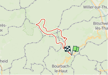
Trail Walking of 11.4 km to be discovered at Grand Est, Haut-Rhin, Bourbach-le-Haut. This trail is proposed by mumu.larandonneuse.

Description

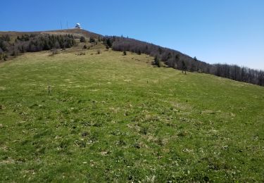
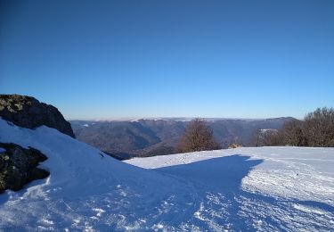
Une randonnée qui vous emmène faire le tour des sommets des Vosges côté alsacien entre vallée de la Doller et vallée de la Thur, non loin de la Forêt des Volcans : un autre versant, d'autres sommets et d'autres vues !
➡️ Suite au reportage du 13h00 de TF1 du 12/01/24 sur la ferme auberge du Gsang, repas à la bougie.
➡️ En raquettes si neige
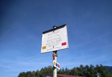
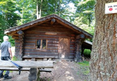
➡️ Départ : Bourbach la Haut - Col du Hunsdrück
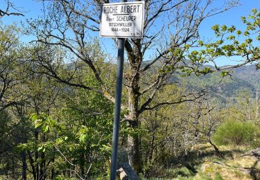
➡️ Type de balisage : Club vosgien
Carte IGN : N° de la carte : 3620 ET
🅿️ Parking : Bourbach la Haut - Col du Hunsdrück

Elevation profile

Photos

Positioning

Country:
France
Region :
Grand Est
Department/Province :
Haut-Rhin
Municipality :
Bourbach-le-Haut
Location:
Unknown
Start:(Dec)
Start:(UTM)
353441 ; 5296617 (32T) N.

Trails nearby

Trail Walking Masevaux-Niederbruck - Masevaux - Rossberg par le belvédère du Fuchsfelsen - Photo
Walking
Bart2015

Walking

Medium
(1)
Masevaux-Niederbruck, Grand Est, Haut-Rhin, France
19.9 km | 34 km-effort
4h 44min
Yes
Trail Walking Thann - SityTrail - 2489713 - thann-roche--albert--grumbachkopf - Photo
Walking
argonneuweg

Walking

Medium
(1)
Thann, Grand Est, Haut-Rhin, France
7.6 km | 12 km-effort
2h 28min
Yes
Trail On foot Bitschwiller-lès-Thann - Bitschwiller les Thann - Rehbrunnel - Abri du Becherkopf - Roche Albert - Photo
On foot
patrickbeyrath

On foot

Medium
(1)
Bitschwiller-lès-Thann, Grand Est, Haut-Rhin, France
10.3 km | 16.4 km-effort
Unknown
Yes
Trail Walking Bitschwiller-lès-Thann - 68 Col du Hundsrück  - FA Gsang - retour ThannerHubel - Photo
Walking

Walking

Medium
(1)
Bitschwiller-lès-Thann, Grand Est, Haut-Rhin, France
11.2 km | 18.4 km-effort
3h 48min
Yes
Trail Walking Willer-sur-Thur - Willer sur Thur col du Haag  - Photo
Walking
gamille67

Walking

Medium
Willer-sur-Thur, Grand Est, Haut-Rhin, France
29 km | 46 km-effort
6h 45min
Yes
Trail Walking Bitschwiller-lès-Thann - JD 16/20 Willer sur Thur - Ferme Auberge d'Ostein 15km 4h - Photo
Walking
argonneuweg

Walking

Difficult
Bitschwiller-lès-Thann, Grand Est, Haut-Rhin, France
15.1 km | 22 km-effort
4h 7min
Yes
Trail Snowshoes Bourbach-le-Haut - Sortie raquettes Hundsruck Belacker - Photo
Snowshoes
helmut68

Snowshoes

Medium
Bourbach-le-Haut, Grand Est, Haut-Rhin, France
14.9 km | 23 km-effort
2h 50min
Yes
Trail Walking Masevaux-Niederbruck - Les Dames nobles de Masevaux  - Photo
Walking
helmut68

Walking

Medium
Masevaux-Niederbruck, Grand Est, Haut-Rhin, France
12.3 km | 17.6 km-effort
3h 0min
Yes
Trail Walking Sickert - Départ de Sickert dir Sattelboden 26/08/2021) - Photo
Walking
Richard68500

Walking

Difficult
Sickert, Grand Est, Haut-Rhin, France
16.4 km | 26 km-effort
4h 52min
Yes


Close
My subscriptions