Trail Walking Saint-Jean-de-Fos - St Jean de Fos et le Max Nègre - Photo

St Jean de Fos et le Max Nègre

 randotines
randotines

User GUIDE

© OpenStreetMap contributors
Length
Length
19.1 km
Max alt
Max alt
545 m
Uphill gradient
Uphill gradient
567 m
Km-Effort
Km-Effort  
27 km
Min alt
Min alt
91 m
Downhill gradient
Downhill gradient
568 m
Boucle
Boucle
Yes
Creation date :
2014-12-10 00:00:00.0
Updated on :
2014-12-10 00:00:00.0

(0 Reviews)

Walking
Walking
5h42
Difficulty : Medium

Scan this QR Code to open this trail in the SityTrail application

FREE GPS app for hiking

Logo SityTrail SityTrail

IGN / Geographical institutes

Download SityTrail from the App Store Download SityTrail from Google Play

Logo SityTrail SityTrail World

The world is yours!

Download SityTrail from the App Store Download SityTrail from Google Play Download SityTrail on Huawei AppGallery

About

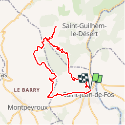
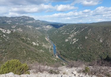
Trail Walking of 19.1 km to be discovered at Occitania, Hérault, Saint-Jean-de-Fos. This trail is proposed by randotines.

Description

Belle rando au départ de St Jean de Fos ( Hérault ) près de St Guilhem le désert.Parking soit le long du cimetière soit à l'Argileum ( la maison de la poterie ).

Elevation profile

Photos

Points of interest

Point of interest Saint-Guilhem-le-Désert - Lavogne - Photo
randotines
SAINT-GUILHEM-LE-DÉSERT 
Point of interest Saint-Guilhem-le-Désert - lavogne - Photo
randotines
SAINT-GUILHEM-LE-DÉSERT 
Point of interest Saint-Guilhem-le-Désert - lavogne - Photo
randotines
SAINT-GUILHEM-LE-DÉSERT 
Point of interest Saint-Guilhem-le-Désert - Point 3 - Photo
randotines
SAINT-GUILHEM-LE-DÉSERT 
Point of interest Saint-Guilhem-le-Désert - Point 3 - Photo
randotines
SAINT-GUILHEM-LE-DÉSERT 
Point of interest Saint-Guilhem-le-Désert - Belvedere du Max negre - Photo
randotines
SAINT-GUILHEM-LE-DÉSERT 
Point of interest Saint-Guilhem-le-Désert - Belvedere du Max negre - Photo
randotines
SAINT-GUILHEM-LE-DÉSERT 
Point of interest Montpeyroux - Point 10 - Photo
randotines
MONTPEYROUX 
Point of interest Montpeyroux - Point 10 - Photo
randotines
MONTPEYROUX 

Positioning

Country:
France
Region :
Occitania
Department/Province :
Hérault
Municipality :
Saint-Jean-de-Fos
Location:
Unknown
Start:(UTM)
544530 ; 4839097 (31T) N.

Trails nearby

Trail Walking Aniane - Aniane ruisseau des Corbières - Photo
Walking
kephas

Walking

Easy
(3)
Aniane, Occitania, Hérault, France
9.5 km | 12 km-effort
2h 34min
Yes
Trail Walking Saint-Jean-de-Fos - St Jean de fos Les Plos - Photo
Walking
mrclic34

Walking

Easy
(3)
Saint-Jean-de-Fos, Occitania, Hérault, France
11 km | 15.2 km-effort
3h 5min
Yes
Trail Walking Montpeyroux - château de castelas - Photo
Walking
mrclic34

Walking

Easy
(3)
Montpeyroux, Occitania, Hérault, France
10.3 km | 15.1 km-effort
3h 12min
Yes
Trail Walking Montpeyroux - Saint baudille - Photo
Walking
yt34

Walking

Easy
(3)
Montpeyroux, Occitania, Hérault, France
10.2 km | 16.2 km-effort
3h 22min
Yes
Trail Walking Saint-Guilhem-le-Désert - Herault - St-Guilhem-le-Desert le Roc de la Vigne depuis le barrage 12km 609m - Photo
Walking
RandoVal

Walking

Medium
(1)
Saint-Guilhem-le-Désert, Occitania, Hérault, France
12.1 km | 21 km-effort
4h 17min
Yes
Trail Walking Puéchabon - Causse Puechabon - Photo
Walking
dpop34

Walking

Very easy
(1)
Puéchabon, Occitania, Hérault, France
12.8 km | 15.9 km-effort
Unknown
Yes
Trail Walking Saint-Guilhem-le-Désert - St Guilhem Le Désert - Mas Aubert - Photo
Walking
tracegps

Walking

Difficult
(1)
Saint-Guilhem-le-Désert, Occitania, Hérault, France
19.7 km | 30 km-effort
6h 30min
Yes
Trail Walking Montpeyroux - Le bary Arboras le Castelas - Photo
Walking
labarone

Walking

Easy
Montpeyroux, Occitania, Hérault, France
11.8 km | 17.1 km-effort
5h 7min
Yes
Trail Walking Saint-Guilhem-le-Désert - de Saint guilhem le désert au plot - Photo
Walking
labarone

Walking

Medium
Saint-Guilhem-le-Désert, Occitania, Hérault, France
16.8 km | 26 km-effort
6h 5min
Yes


Close
My subscriptions