Trail On foot Arreau - ARREAU Frechet-Aure Arreau en passant par le calvaire G3

ARREAU Frechet-Aure Arreau en passant par le calvaire G3 "2307512"

 marmotte65
marmotte65

User GUIDE

© OpenStreetMap contributors
Length
Length
8.3 km
Max alt
Max alt
896 m
Uphill gradient
Uphill gradient
238 m
Km-Effort
Km-Effort  
11.5 km
Min alt
Min alt
676 m
Downhill gradient
Downhill gradient
238 m
Boucle
Boucle
Yes
Creation date :
2020-01-17 08:17:14.744
Updated on :
2024-04-13 12:28:56.93

(0 Reviews)

On foot
On foot
--
Difficulty : Easy

Scan this QR Code to open this trail in the SityTrail application

FREE GPS app for hiking

Logo SityTrail SityTrail

IGN / Geographical institutes

Download SityTrail from the App Store Download SityTrail from Google Play

Logo SityTrail SityTrail World

The world is yours!

Download SityTrail from the App Store Download SityTrail from Google Play Download SityTrail on Huawei AppGallery

About

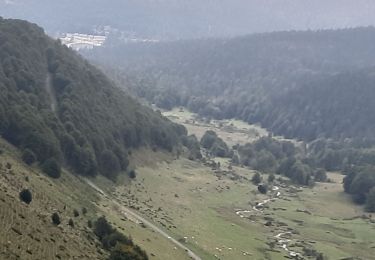
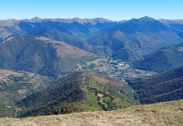
Trail On foot of 8.3 km to be discovered at Occitania, Hautespyrenees, Arreau. This trail is proposed by marmotte65.

Description

Au départ de la place du marché de Arreau (sauf le jeudi) c'est  le jour du marché tres jolie rando sans difficulté. voir les possibilites avec le GR 105 sur plusieurs jours pour G3 ou G4.
possibilite de couper pour rejoindre la D109 (avant le cimetiere prendre la rue a gauche puis plus loin le sentier à gauche pour revenir sur la D109

Elevation profile

Positioning

Country:
France
Region :
Occitania
Department/Province :
Hautespyrenees
Municipality :
Arreau
Location:
Unknown
Start:(UTM)
284527 ; 4753601 (31T) N.

Trails nearby

Trail Walking Ancizan - Lac d'Arou - Payolle - Photo
Walking
tracegps

Walking

Medium
(4)
Ancizan, Occitania, Hautespyrenees, France
9.8 km | 14.9 km-effort
3h 30min
Yes
Trail Snowshoes Campan - raquet 1 - Photo
Snowshoes
eliott3

Snowshoes

Easy
(1)
Campan, Occitania, Hautespyrenees, France
4.9 km | 7.2 km-effort
2h 10min
Yes
Trail Walking Campan - payolle - Photo
Walking
yfouldrin

Walking

Very easy
(1)
Campan, Occitania, Hautespyrenees, France
6.5 km | 8.2 km-effort
1h 52min
Yes
Trail Walking Ancizan - lac d'Arou Ancizan - Photo
Walking
Forsans

Walking

Easy
Ancizan, Occitania, Hautespyrenees, France
5.5 km | 7.5 km-effort
1h 33min
No
Trail Nordic walking Campan - parcours 9 km Lac de Payolle - Photo
Nordic walking
GIRAUDEL

Nordic walking

Very easy
Campan, Occitania, Hautespyrenees, France
8.7 km | 11.7 km-effort
Unknown
Yes
Trail Walking Barrancoueu - Hourquette d'Arreau par Barrancoueu - Photo
Walking
dridri002

Walking

Medium
Barrancoueu, Occitania, Hautespyrenees, France
12.3 km | 23 km-effort
5h 56min
Yes
Trail Snowshoes Campan - Pla des Bouhouèrès - Payolle - Photo
Snowshoes
tracegps

Snowshoes

Difficult
Campan, Occitania, Hautespyrenees, France
13.6 km | 24 km-effort
6h 30min
Yes
Trail Snowshoes Campan - Le Plo Del Naou - Payolle - Photo
Snowshoes
tracegps

Snowshoes

Difficult
Campan, Occitania, Hautespyrenees, France
9.8 km | 18.3 km-effort
6h 45min
Yes
Trail Walking Aspin-Aure - plot del naou  col d'Aspin - Photo
Walking
bliguet

Walking

Medium
Aspin-Aure, Occitania, Hautespyrenees, France
6.5 km | 10.8 km-effort
5h 40min
Yes


Close
My subscriptions