


peter2

Damien6
User
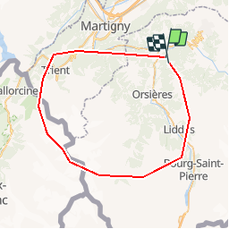

Length
54 km

Max alt
3809 m

Uphill gradient
9681 m
Km-Effort
181 km

Min alt
549 m

Downhill gradient
9236 m
Boucle
No
Creation date :
2014-12-11 00:00:00.0
Updated on :
2014-12-11 00:00:00.0
--
Difficulty : Unknown

FREE GPS app for hiking
 SityTrail
IGN / Geographical institutes
SityTrail Plus
The world is yours!
About
Trail Other activity of 54 km to be discovered at Valais/Wallis, Entremont, Sembrancher. This trail is proposed by Damien6.
Description
Tour sympathique qui vous fait découvrir tous les apsects de la forêt autour de la coline.
Positioning
Country:
Switzerland
Region :
Valais/Wallis
Department/Province :
Entremont
Municipality :
Sembrancher
Location:
Unknown
Start:(Dec)
Start:(UTM)
358158 ; 5103319 (32T) N.
Comments